


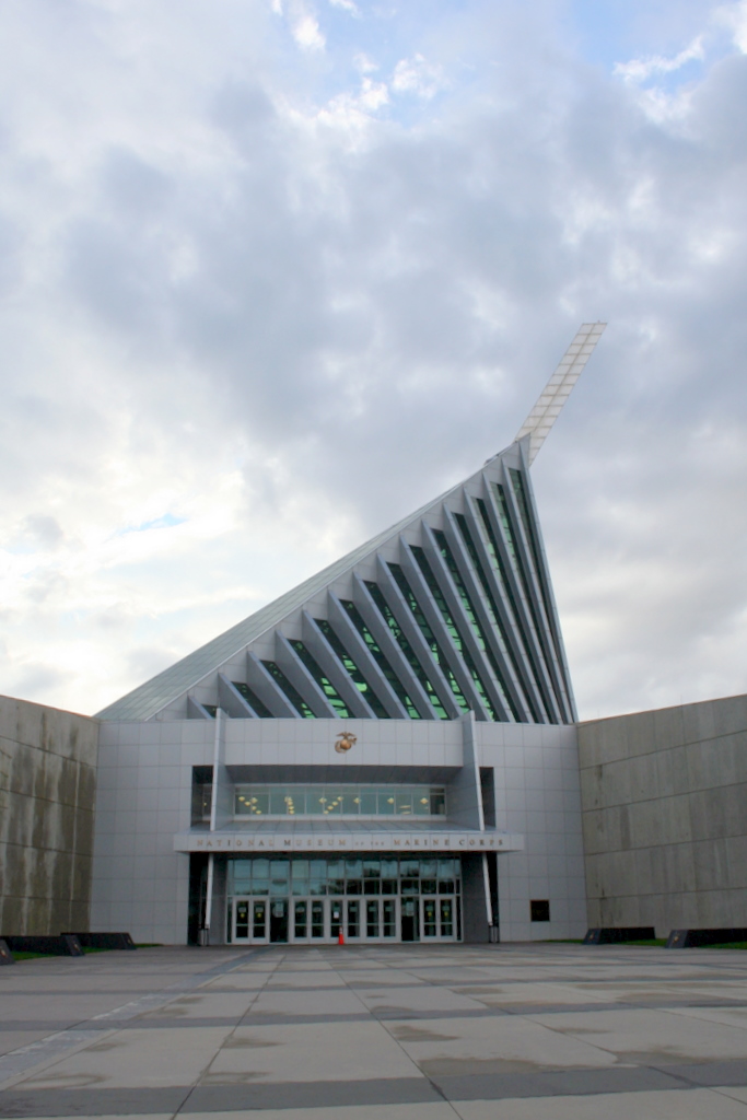

Quantico Base, Virginia
Quantico Base is a community of 5,840 people in Prince William County, Virginia, founded in 1917.
Why visit Quantico Base
Townapedia lists 56 museums and landmarks, 8 parks and trails, 10 places to eat, 2 places to stay and 4 attractions in and around town.
Highlights include Marine Corps University, The National Museum of the Marine Corps, Commanding General's Quarters, Quantico Marine Base and Locust Shade Park.
July is the warmest month, with average highs of 88°F; January lows average 28°F.
Weather in Quantico Base
Forecast from the National Weather Service. Full forecast
About Quantico Base
Marine Corps Base Quantico (commonly abbreviated MCB Quantico) is a United States Marine Corps installation near Triangle, Virginia, covering nearly 55,148 acres (86.169 sq mi; 22,318 ha; 223.18 km2) of southern Prince William County, Virginia, northern Stafford County, and southeastern Fauquier County. Used primarily for training and run on a budget of around $300 million, MCB Quantico is known as the "Crossroads of the Marine Corps".
From the Wikipedia article Marine Corps Base Quantico (this version), under CC BY-SA 4.0.
Things to do4

Marine Corps University
School · 1.5 mi
University for the U.S. Marine Corps

Museums and landmarks56

The National Museum of the Marine Corps
Museum · 2.3 mi
1775 Semper Fidelis Way, Triangle
Mo-Su 09:00-17:00; Dec 25 off

Commanding General's Quarters, Quantico Marine Base
Monument and historic site · National Register of Historic Places · 1.3 mi
Historic house in Virginia, United States

Marine Corps Base Quantico
Monument and historic site · National Register of Historic Places · 1.3 mi
Marine corps base in Virginia, United States

Old Hotel
Monument and historic site · National Register of Historic Places · 3.6 mi
Hotel in Dumfries, Virginia
Orenda/SP-26 Historic District, Chopawamsic RDA Camp 3
Monument and historic site · National Register of Historic Places · 4.0 mi
Recreational demonstration camp

Weems–Botts Museum
Museum · National Register of Historic Places · 3.6 mi
Building in Virginia, United States

Old Town Hall and School
Monument and historic site · National Register of Historic Places · 3.6 mi

Mallows Bay
Monument and historic site · 4.1 mi
Bay in Charles County, Maryland, United States
National Museum of the Marine Corps
Museum · 2.3 mi
Official museum of the United States Marine Corps, in Triangle, Virginia

Crusading for Right
Monument and historic site · 1.3 mi
Monument in the memory of the officers and men of the 6th Machine Gun Battalion, 5th Regiment and 6th Regiment, United States Marines,...

44 more on the map.
Parks, trails and playgrounds8







Restaurants and cafes10

Sam's Inn Restaurant
Restaurant · American, Italian · 1.6 mi
223 Potomac Avenue
Mo-Fr 10:00-22:00; Sa 16:00-22:00; PH closed
Tokyo Japanese Restaurant and Sushi
Restaurant · Japanese, Sushi · 1.5 mi
402 Potomac Avenue, Quantico

Domino's
Fast food · Pizza · 1.5 mi
338 Potomac Avenue, Quantico
Mo-Th 10:00-24:00; Fr-Sa 10:00-01:00; Su 10:00-24:00
Dunkin'
Fast food · Donut, Coffee Shop · 1.6 mi
3500 Russell Road, Quantico
Mo-Fr 06:00-17:00; Sa-Su 08:00-17:00
McDonald's
Fast food · Burger · 1.5 mi
3500 A Russell Road, Quantico
Mo-Sa 05:00-22:00; Su 06:00-22:00
Where to stay2
Churches and places of worship6
Shopping3
Gas and EV charging1
Schools, colleges and libraries20
Map of Quantico Base
110 places. The map loads OpenStreetMap tiles when you open it.
Climate by month
Monthly table
| Month | High | Low | Rain | Snow |
|---|---|---|---|---|
| Jan | 45°F | 28°F | 2.7 in | 3.5 in |
| Feb | 48°F | 30°F | 2.4 in | 5.8 in |
| Mar | 56°F | 37°F | 3.6 in | 1.4 in |
| Apr | 68°F | 47°F | 3.2 in | 0.0 in |
| May | 76°F | 57°F | 3.6 in | 0.0 in |
| Jun | 84°F | 66°F | 3.5 in | 0.0 in |
| Jul | 88°F | 71°F | 4.6 in | 0.0 in |
| Aug | 86°F | 69°F | 4.2 in | 0.0 in |
| Sep | 80°F | 62°F | 3.4 in | 0.0 in |
| Oct | 69°F | 50°F | 3.3 in | 0.0 in |
| Nov | 58°F | 39°F | 3.1 in | 0.0 in |
| Dec | 49°F | 32°F | 3.3 in | 1.7 in |
U.S. Climate Normals 1991-2020 for Quantico Mcas (2 mi away), NOAA NCEI.
People and cost of living
American Community Survey 5-year estimates, 2020-2024, U.S. Census Bureau. Estimates have margins of error, larger for small towns.
Disaster history
Prince William County has had 14 federal disaster declarations since 2000, most often for hurricanes.
- 2026-01-23: Severe Winter Storm (Winter Storm)
- 2020-04-02: Covid-19 Pandemic (Biological)
- 2020-03-13: Covid-19 (Biological)
- 2018-09-11: Hurricane Florence (Hurricane)
- 2016-03-07: Severe Winter Storm And Snowstorm (Snowstorm)
- 2012-11-26: Hurricane Sandy (Hurricane)
OpenFEMA disaster declarations summaries.
Getting there and nearby towns
Quantico Marine Corps Airfield/Turner Field (NYG) is the nearest airport with scheduled flights listed in OpenStreetMap, 1 miles away.
- Triangle 2 mi north, about 3 min by car
- Dumfries 3 mi north, about 5 min by car
- Cherry Hill 4 mi northeast, about 6 min by car
- Aquia Harbour 5 mi southwest, about 8 min by car
- Leesylvania 7 mi north, about 11 min by car
- Montclair 7 mi north, about 11 min by car
- Dale City 9 mi north, about 15 min by car
- Woodbridge 9 mi north, about 15 min by car
- Potomac Mills 10 mi north, about 16 min by car
- Independent Hill 10 mi northwest, about 17 min by car
Drive times are estimates from straight-line distance, not routes.
Local news
Headlines from INDB, the NEMICO news database.
Reviews, tips and questions
Loading what members have shared...
Sources and licences
- NCES EDGE (Public domain): public schools
- NOAA NCEI U.S. Climate Normals 1991-2020 (Public domain): climate by month
- OpenFEMA (Public domain): disaster declarations
- OpenStreetMap contributors (ODbL 1.0): places, airports, map data
- U.S. Census Bureau (Public domain): population, income, housing, education, commute
- Wikidata (CC0 1.0): landmarks and historic places
- Wikimedia Commons (see each image): photos
- Wikipedia (CC BY-SA 4.0): overview and history text
Photo credits
- Weems-Botts House (Dumfries, Virginia) 001, Leonard J. DeFrancisci, CC BY-SA 3.0
- OLD HOTEL; PRINCE WILLIAM COUNTY, Jerrye & Roy Klotz, MD, CC BY-SA 3.0
- Commander's House, LeiferJM, CC BY-SA 3.0
- OLD TOWN HALL AND SCHOOL, PRINCE WILLIAM COUNTY, VA, Jerrye & Roy Klotz, MD, CC BY-SA 3.0
- Museum of the marines corps, RadioFan ( talk ), CC BY-SA 3.0
- Mallows-bay-shipwreck, Amazur, CC BY-SA 3.0
- Marine Corps Air-Ground Museum 05, U.S. Marine Corps, Public domain
- Crusading for Right (1918) scuplture 001, Leonard J. DeFrancisci, CC BY-SA 3.0
Page built October 30, 2026. Spotted a mistake? Tell us or suggest a place.