


Ringwood, New Jersey
Ringwood is a borough of 11,657 people in Passaic County, New Jersey, founded in March 22, 1918.
Why visit Ringwood
Townapedia lists 57 museums and landmarks, 33 parks and trails, 7 places to eat, 2 places to stay and 55 attractions in and around town.
Highlights include Campgaw Mountain Reservation, Warner Bros. Jungle Habitat, Long Pond Ironworks and Crocker-McMillin Mansion-Immaculate Conception Seminary.
July is the warmest month, with average highs of 84°F; January lows average 20°F.
Weather in Ringwood
Forecast from the National Weather Service. Full forecast
About Ringwood
Ringwood is a borough in Passaic County, in the U.S. state of New Jersey. As of the 2020 United States census, the borough's population was 11,735, a decrease of 493 (−4.0%) from the 2010 census count of 12,228, which in turn reflected a decrease of 168 (−1.4%) from the 12,396 counted in the 2000 census.
From the Wikipedia article Ringwood, New Jersey (this version), under CC BY-SA 4.0.
Things to do55

Campgaw Mountain Reservation
Ski area · 5.1 mi
County park in Bergen County

Warner Bros. Jungle Habitat
Zoo and aquarium · 4.1 mi
Former 800 acre animal safari park

43 more on the map.
Museums and landmarks57

Long Pond Ironworks
Monument and historic site · National Register of Historic Places · 3.6 mi
Geographical Feature located in New jersey, USA

Crocker-McMillin Mansion-Immaculate Conception Seminary
Monument and historic site · National Register of Historic Places · 4.7 mi
Historic house in New Jersey, United States
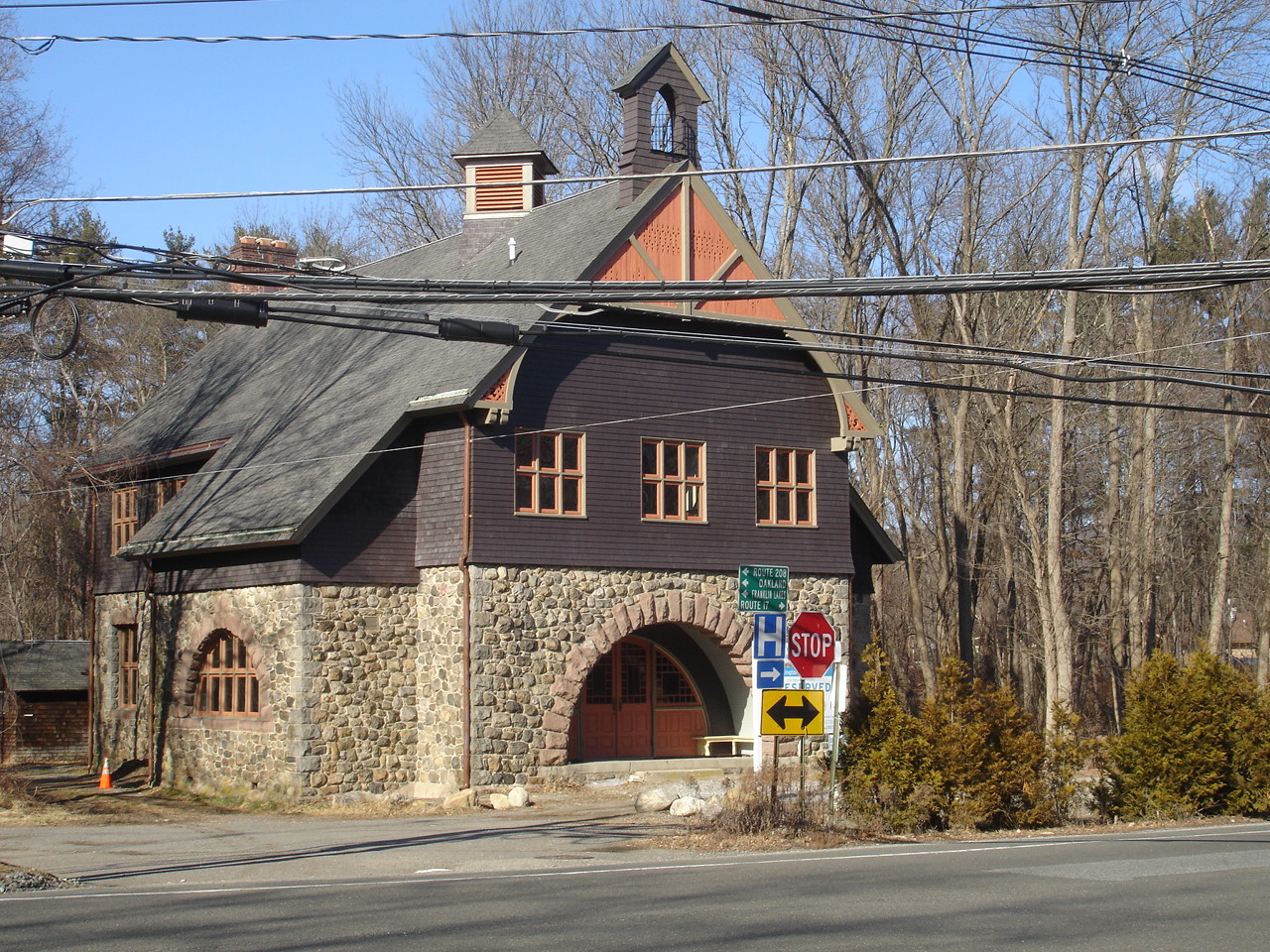
Darlington Schoolhouse
Monument and historic site · National Register of Historic Places · 4.8 mi
School building in New Jersey, United States of America

Demarest House
Monument and historic site · National Register of Historic Places · 6.1 mi
Historic house in Oakland, New Jersey, USA

Hopper-Van Horn House
Monument and historic site · National Register of Historic Places · 5.3 mi
Historic house in Mahwah, New Jersey

Jacob Sloat House
Monument and historic site · National Register of Historic Places · 5.3 mi
Historic house in New York, United States

Jacobus Demarest House
Monument and historic site · National Register of Historic Places · 6.0 mi
Historic house in Oakland, New Jersey

John Bartholf House
Monument and historic site · National Register of Historic Places · 4.4 mi
Dutch colonial house in Mahwah, New Jersey, United States

Main School
Monument and historic site · National Register of Historic Places · 5.5 mi
Historic building in Hillburn, New York, United States

Old Sloatsburg Cemetery
Monument and historic site · National Register of Historic Places · 5.2 mi
Cemetery

Ringwood Manor
Monument and historic site · National Register of Historic Places · 3.0 mi
Historic district in Ringwood, New Jersey


Skylands
Monument and historic site · National Register of Historic Places · 2.3 mi
Historic house and garden in Ringwood State Park, New Jersey
45 more on the map.
Parks, trails and playgrounds33

Tranquility Ridge Park
Park · 3.9 mi
Park in New Jersey, United States of America

21 more on the map.
Restaurants and cafes7



Geppetto's Pizza
Fast food · Pizza · 3.0 mi
365 Ringwood Avenue, Wanaque
Mo-Sa 11:30-21:00; Su 16:00-20:00
History
The Lenape, an Algonquian language-speaking tribe of Native Americans who occupied much of the mid-Atlantic coastal areas and the interior mountains including along the Delaware River resided in the area of present-day Ringwood when Europeans first entered the area. Some retreated to the mountains to escape colonial encroachment.
Colonists called the local band the Ramapough, and named the Ramapo River and other regional features after them. Their descendants and Afro-Dutch migrants from New York were among the people who formed the multiracial group known as the Ramapough Mountain Indians, recognized in 1980 as the "Ramapough Lenape Nation" Native American tribe by the state of New Jersey, though the federal government has denied their application for formal recognition.
Early in the 18th century, colonists discovered iron in the area. The Ogden family built a blast furnace in Ringwood in 1742. By 1765, Peter Hasenclever used Ringwood as the center of his ironmaking operations, which included 150,000 acres (610 km2) in New Jersey, New York and Nova Scotia. Iron mining was prominent in the area from the 18th century until the Great Depression, and iron shafts and pits, landfills and other elements still exist. The London, Roomy, Peters and Hope mines were all originally opened by Peter Hasenclever's London Company.
From the History section of Ringwood, New Jersey on Wikipedia, under CC BY-SA 4.0.
Where to stay2
Churches and places of worship7
Dutch Reformed Church at Romopock
Church · National Register of Historic Places · 6.2 mi
Shopping1
Gas and EV charging4
Schools, colleges and libraries26
Marshall Hill Elementary School
School · 4.6 mi
210 Marshall Hill Road, West Milford
Map of Ringwood
192 places. The map loads OpenStreetMap tiles when you open it.
Climate by month
Monthly table
| Month | High | Low | Rain |
|---|---|---|---|
| Jan | 38°F | 20°F | 3.4 in |
| Feb | 40°F | 20°F | 2.7 in |
| Mar | 48°F | 29°F | 3.9 in |
| Apr | 60°F | 39°F | 4.2 in |
| May | 71°F | 50°F | 3.6 in |
| Jun | 79°F | 58°F | 5.1 in |
| Jul | 84°F | 64°F | 4.7 in |
| Aug | 83°F | 63°F | 4.6 in |
| Sep | 76°F | 56°F | 4.0 in |
| Oct | 64°F | 43°F | 4.4 in |
| Nov | 53°F | 35°F | 3.8 in |
| Dec | 43°F | 27°F | 4.0 in |
U.S. Climate Normals 1991-2020 for Wanaque Raymond Dam (4 mi away), NOAA NCEI.
People and cost of living
American Community Survey 5-year estimates, 2020-2024, U.S. Census Bureau. Estimates have margins of error, larger for small towns.
Disaster history
Passaic County has had 20 federal disaster declarations since 2000, most often for hurricanes.
- 2021-09-05: Remnants Of Hurricane Ida (Hurricane)
- 2021-09-02: Remnants Of Hurricane Ida (Hurricane)
- 2020-03-25: Covid-19 Pandemic (Biological)
- 2020-03-13: Covid-19 (Biological)
- 2018-06-08: Severe Winter Storm And Snowstorm (Severe Storm)
- 2012-10-30: Hurricane Sandy (Hurricane)
OpenFEMA disaster declarations summaries.
Getting there and nearby towns
Essex County Airport (CDW) is the nearest airport with scheduled flights listed in OpenStreetMap, 16 miles away.
- Oakland 5 mi south, about 9 min by car
- Ramsey 7 mi southeast, about 11 min by car
- Pompton Lakes 7 mi south, about 11 min by car
- Franklin Lakes 7 mi southeast, about 12 min by car
- Pompton Plains 10 mi south, about 16 min by car
- Kinnelon 10 mi southwest, about 17 min by car
- Glen Rock 13 mi southeast, about 20 min by car
- Lincoln Park 13 mi south, about 20 min by car
- Oak Ridge 13 mi southwest, about 21 min by car
- Paterson 14 mi southeast, about 23 min by car
Drive times are estimates from straight-line distance, not routes.
Local news
Headlines from INDB, the NEMICO news database.
Reviews, tips and questions
Loading what members have shared...
Sources and licences
- NCES EDGE (Public domain): public schools
- NOAA NCEI U.S. Climate Normals 1991-2020 (Public domain): climate by month
- OpenFEMA (Public domain): disaster declarations
- OpenStreetMap contributors (ODbL 1.0): places, airports, map data
- U.S. Census Bureau (Public domain): population, income, housing, education, commute
- Wikidata (CC0 1.0): elevation, founding date, time zone, website, landmarks and historic places
- Wikimedia Commons (see each image): photos
- Wikipedia (CC BY-SA 4.0): overview and history text
Photo credits
- Ringwood Manor spring 2015, Daniel Case, CC BY-SA 3.0
- Wanaque Reservoir, Ringwood, New Jersey, USA October 2006 - panoramio, Gary Miotla, CC BY 3.0
- 2018-07-25 18 06 10 View north along Passaic County Route 511 (Greenwood Lake Turnpike) just north of Passaic County Route 692 (Skyline Drive) in Ringwood, Passaic County, New Jersey, Famartin, CC BY-SA 4.0
- Ringwood, NJ municipal building, May 2025, Mr. Matté (if there is an issue with this image, contact me using this image's Commons talk page , my Commons user talk page , or my English Wikipedia user talk page ; I'll know about it a lot faster), CC BY-SA 4.0
- 2025-03-21 13 28 44 The Ringwood Remote Automated Weather Station (RAWS) within Ringwood State Park in Ringwood, Passaic County, New Jersey, Famartin, CC BY-SA 4.0
- 2025-03-21 13 28 50 The anemometer of the Ringwood Remote Automated Weather Station (RAWS) within Ringwood State Park in Ringwood, Passaic County, New Jersey, Famartin, CC BY-SA 4.0
- 2025-03-21 13 28 26 The Ringwood Remote Automated Weather Station (RAWS) within Ringwood State Park in Ringwood, Passaic County, New Jersey, Famartin, CC BY-SA 4.0
- 2024-10-22 13 24 47 Autumn view from the Monksville Dam northwestward along the northeast shore of Monksville Reservoir in Ringwood, Passaic County, New Jersey, Famartin, CC BY-SA 4.0
- 2024-10-22 13 24 50 Autumn view from the Monksville Dam west-southwestward across Monksville Reservoir in Ringwood, Passaic County, New Jersey, Famartin, CC BY-SA 4.0
- 2024-10-22 13 24 52 Autumn view from the Monksville Dam southwestward across Monksville Reservoir in Ringwood, Passaic County, New Jersey, Famartin, CC BY-SA 4.0
- 2024-10-22 13 24 43 Autumn view from the Monksville Dam northwestward along the northeast shore of Monksville Reservoir in Ringwood, Passaic County, New Jersey, Famartin, CC BY-SA 4.0
- 2024-10-22 13 24 39 Autumn view from the Monksville Dam west-southwestward across Monksville Reservoir in Ringwood, Passaic County, New Jersey, Famartin, CC BY-SA 4.0
- 2024-10-22 13 24 49 Autumn view from the Monksville Dam westward across Monksville Reservoir in Ringwood, Passaic County, New Jersey, Famartin, CC BY-SA 4.0
- 2024-10-22 09 55 09 Autumn view from the Monksville Dam northwestward along the northeast shore of Monksville Reservoir in Ringwood, Passaic County, New Jersey, Famartin, CC BY-SA 4.0
- 2024-10-22 09 55 03 Autumn view from the Monksville Dam northwestward along the northeast shore of Monksville Reservoir in Ringwood, Passaic County, New Jersey, Famartin, CC BY-SA 4.0
- Penn Station Eagle by Weinman, at Ringwood, NJ, on left, Zeete, CC BY-SA 3.0
- Penn Station Eagle by Weinman, at Ringwood, NJ, on right, Zeete, CC BY-SA 3.0
- 2018-07-25 18 31 47 View south along Passaic County Route 511 (Greenwood Lake Turnpike) just south of Passaic County Route 698 (Margaret King Avenue) in Ringwood, Passaic County, New Jersey, Famartin, CC BY-SA 4.0
- RingwoodManorForges 20230610 124730, CaptJayRuffins, CC BY-SA 4.0
- Ringwood Manor, NJ - iron gate, Zeete, CC BY-SA 4.0
- Ringwood Manor, NJ - civil war mortar, Zeete, CC BY-SA 4.0
- OldCountryStoreLPIW, KForce at en.wikipedia, CC BY-SA 3.0
- DutchReformedChurchMahwah, KForce at en.wikipedia, CC BY-SA 3.0
- BrookChapel, JFino, CC BY-SA 3.0
- JOHN BARTHOLF HOUSE, MAHWAH, BERGEN COUNTY, JERRYE & ROY KLOTZ M.D., CC BY-SA 4.0
- HENDRICK VAN ALLEN HOUSE, OAKLAND, BERGEN COUNTY, NJ, JERRYE & ROY KLOTZ M.D., CC BY-SA 4.0
- CROCKER-McMILLIN MANSION - IMMACULATE CONCEPTION SEMINARY, MAHWAH, BERGEN COUNTY, JERRYE & ROY KLOTZ M.D., CC BY-SA 4.0
- TORNE BROOK FARM, RAMAPO, ROCKLAND COUNTY NY, JERRYE & ROY KLOTZ, M.D., CC BY-SA 4.0
- DarlingtonSchoolhouse, KForce at English Wikipedia, CC BY-SA 3.0
- HOPPER-VAN HORN HOUSE, MAHWAH, BERGEN COUNTY, NJ, JERRYE & ROY KLOTZ M.D., CC BY-SA 4.0
- Former Main School building - Hillburn, NY (2010), Doug Kerr from Albany, NY, United States, CC BY-SA 2.0
- Sloat's Dam and Mill Pond 2, Daniel Case, CC BY-SA 3.0
- Demarest House, Oakland, Bergen County, NJ, JERRYE & ROY KLOTZ M.D., CC BY-SA 4.0
- Old Sloatsburg Cemetery, Daniel Case, CC BY-SA 3.0
- Jacob Sloat House - c1900, Anonymous Unknown author, Public domain
- Sloat House, Sloatsburg, NY, Daniel Case, CC BY-SA 3.0
- JACOBUS S. DEMAREST HOUSE, OAKLAND, BERGEN COUNTY, NJ, JERRYE & ROY KLOTZ M.D., CC BY-SA 4.0
- Skylands, Mwanner at en.wikipedia, CC BY-SA 3.0
- VAN WINKLE-FOX HOUSE, OAKLAND, BERGEN COUNTY, NJ, JERRYE & ROY KLOTZ M.D., CC BY-SA 4.0
- CampgawMountainReservation FykePond, Lithium6ion, Public domain


Page built October 30, 2026. Spotted a mistake? Tell us or suggest a place.