


Seat Pleasant, Maryland
Seat Pleasant is a city of 4,489 people in Prince George's County, Maryland, founded in 1931.
Why visit Seat Pleasant
Townapedia lists 15 museums and landmarks, 22 parks and trails, 10 places to eat and 2 attractions in and around town.
Highlights include Amtrak Railroad Anacostia Bridge, New York Avenue Bridge, Beall's Pleasure and Concord.
July is the warmest month, with average highs of 90°F; January lows average 28°F.
Weather in Seat Pleasant
Forecast from the National Weather Service. Full forecast
About Seat Pleasant
Seat Pleasant is an incorporated city in Prince George's County, Maryland, United States, located immediately east of Washington, D.C.. Per the 2020 census, the population was 4,522. Two state highways pass through the community — Maryland routes 704 (now called Martin Luther King Jr. Highway and previously named George Palmer Highway in honor of banker and community leader George Palmer) and 214 (Central Avenue). The Washington Metro's Blue and Silver Lines are nearby.
From the Wikipedia article Seat Pleasant, Maryland (this version), under CC BY-SA 4.0.
Things to do2

Amtrak Railroad Anacostia Bridge
Bridge · 2.8 mi
Bridge in United States of America

New York Avenue Bridge
Bridge · 2.8 mi
Bridge crossing over the Anacostia River in Washington, D.C.
Museums and landmarks15

Beall's Pleasure
Monument and historic site · National Register of Historic Places · 2.6 mi
Historic house in Landover, Maryland, United States
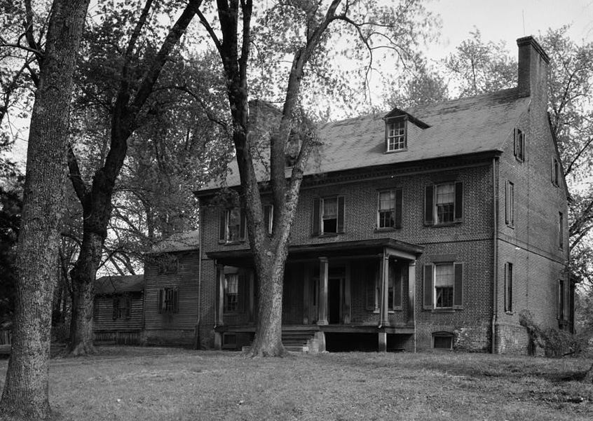
Concord
Monument and historic site · National Register of Historic Places · 2.1 mi
Historic house in District Heights, Maryland, United States

Engine Company 27
Monument and historic site · National Register of Historic Places · 2.4 mi
Fire station in Washington, D.C.

Fairmount Heights Historic District
Monument and historic site · National Register of Historic Places · 1.0 mi
Historic district in Maryland, USA

John Philip Sousa Junior High School
Monument and historic site · National Register of Historic Places · 2.9 mi
Historic school building in Washington, D.C., United States

Mayfair Mansions Apartments
Monument and historic site · National Register of Historic Places · 2.7 mi
Washington, D.C

Mount Hope
Monument and historic site · National Register of Historic Places · 2.0 mi
Human settlement in Maryland, United States of America

Nannie Helen Burroughs School
Monument and historic site · National Register of Historic Places · 1.6 mi
Historic school formerly named Trades Hall of National Training School for Women and Girls

Ridgeley School
Monument and historic site · National Register of Historic Places · 2.1 mi
Historic school in Capitol Heights, Maryland, United States

Strand Theater
Monument and historic site · National Register of Historic Places · 1.5 mi
Former movie theater in Washington D.C.

Woodlawn Cemetery
Monument and historic site · National Register of Historic Places · 2.2 mi
Cemetery in Washington, D.C.
Ghost Bike Memorial
Monument and historic site · 1.3 mi
Ghost bike memorial for an unidentified cyclist who was killed by a driver on Eastern Ave NE on July 4, 2023.
3 more on the map.
Parks, trails and playgrounds22
Kenilworth Park and Aquatic Gardens
Park · National Register of Historic Places · 2.8 mi
Park in Washington, D.C., United States

Bladensburg Dueling Grounds
Park · 3.0 mi
Site where more than 50 duels were fought during the 1800s in Maryland, US



10 more on the map.
Restaurants and cafes10

China Chef's Carry Out
Restaurant · Chinese
5925 Martin Luther King Jr. Highway, Capitol Heights
Far East Carry-Out
Restaurant · Chinese · 0.4 mi
5920 Martin Luther King Jr. Highway, Capitol Heights

Domino's
Fast food · Pizza · 0.5 mi
6254 Central Avenue, Capitol Heights
Mo-Th 10:00-24:00; Fr-Sa 10:00-01:00; Su 10:00-24:00
Dunkin'
Fast food · Donut, Coffee Shop · 0.5 mi
6412 Central Avenue, Capitol Heights
Mo-Fr 05:00-20:00; Sa-Su 06:00-20:00
Popeyes
Fast food · Chicken · 0.5 mi
6214 Central Avenue, Seat Pleasant
Mo-Th 10:00-23:00; Fr-Sa 10:00-24:00; Su 10:00-23:00
Taco Bell
Fast food · Tex-Mex · 0.5 mi
6250 Central Avenue, Capitol Heights
Mo-Th 08:00-02:00; Fr-Sa 08:00-03:00; Su 08:00-02:00
History
Seat Pleasant is located on part of what had been the Williams-Berry estate. In 1850, the descendants of General Otho Holland Williams, a Revolutionary War hero, and James Berry, a mid-17th-century Puritan leader, sold it to Joseph Gregory. Seat Pleasant was developed on the dairy farm of Joseph Gregory, the farm of the Hill family, and the land of building contractor Francis Carmody, among others. In 1873, some of the land along Addison Road was subdivided into small farms and rural home sites known as Jackson's Subdivision.
Designers of the Chesapeake Beach Railway, constructed in 1897–99 between Washington, D.C. and Chesapeake Beach, Maryland, located their first station in Maryland outside Washington on the railway's right-of-way that traversed the Gregory property. They called the station "District Line". The Columbia Railway Company operated a streetcar system that extended through Northeast Washington and terminated in Seat Pleasant at Eastern Avenue, near what is today Martin Luther King Jr. Highway. Finally, the Washington, Baltimore and Annapolis Electric Railway passed through Seat Pleasant in 1908. In 1906, the growing number of residents in the area around the station adopted a more imaginative name for their community — Seat Pleasant, after the early Williams-Berry estate. Prior to that, the area was known as Chesapeake Junction.
From the History section of Seat Pleasant, Maryland on Wikipedia, under CC BY-SA 4.0.
Churches and places of worship58
First Baptist Church of Deanwood
Church · National Register of Historic Places · 2.2 mi
Ridgley Methodist Episcopal Church
Church · National Register of Historic Places · 2.5 mi
St. Matthew's Church
Church · National Register of Historic Places · 0.7 mi
Contee African Methodist Episcopal Zion Church
Church · African Methodist Episcopal Zion · 1.4 mi
903 Division Avenue Northeast
Corinth Baptist Church
Church · Baptist · 0.6 mi
903 Cypresstree Drive, Capitol Heights
Beulah Baptist Church of Deanwood
Church · Baptist · 0.9 mi
5820 Dix Street Northeast
Shopping3
Gas and EV charging7
Schools, colleges and libraries70
DC Scholars
School · 1.3 mi
5601 5601 E Capitol Street SE, Washington, DC 20019, Washington
Cesar Chavez Public Charter Schools For Public Policy
School · 2.7 mi
3701 Hayes Street Ne, Washington
Elsie Whitlow Stokes Community Freedom Pcs - Brookland
School · 5.6 mi
3700 Oakview Terrace Ne, Washington
Elsie Whitlow Stokes Community Freedom Pcs - East End
School · 1.2 mi
5600 East Capitol Street Ne, Washington
Map of Seat Pleasant
187 places. The map loads OpenStreetMap tiles when you open it.
Climate by month
Monthly table
| Month | High | Low | Rain | Snow |
|---|---|---|---|---|
| Jan | 45°F | 28°F | 3.0 in | 4.7 in |
| Feb | 48°F | 30°F | 2.8 in | 2.3 in |
| Mar | 56°F | 36°F | 4.0 in | 1.4 in |
| Apr | 68°F | 46°F | 3.4 in | 0.0 in |
| May | 77°F | 57°F | 4.3 in | 0.0 in |
| Jun | 85°F | 66°F | 4.6 in | 0.0 in |
| Jul | 90°F | 71°F | 4.6 in | 0.0 in |
| Aug | 88°F | 69°F | 3.7 in | 0.0 in |
| Sep | 82°F | 62°F | 4.1 in | 0.0 in |
| Oct | 70°F | 49°F | 4.2 in | 0.0 in |
| Nov | 58°F | 39°F | 3.2 in | 0.0 in |
| Dec | 49°F | 32°F | 3.7 in | 1.3 in |
U.S. Climate Normals 1991-2020 for Natl Arboretum Dc (4 mi away), NOAA NCEI.
People and cost of living
American Community Survey 5-year estimates, 2020-2024, U.S. Census Bureau. Estimates have margins of error, larger for small towns.
Disaster history
Prince George's County has had 13 federal disaster declarations since 2000, most often for hurricanes.
- 2026-01-24: Severe Winter Storm (Winter Storm)
- 2020-03-26: Covid-19 Pandemic (Biological)
- 2020-03-13: Covid-19 (Biological)
- 2016-03-04: Severe Winter Storm And Snowstorm (Snowstorm)
- 2012-11-20: Hurricane Sandy (Hurricane)
- 2012-10-28: Hurricane Sandy (Hurricane)
OpenFEMA disaster declarations summaries.
Getting there and nearby towns
Joint Base Andrews (ADW) is the nearest airport with scheduled flights listed in OpenStreetMap, 6 miles away.
- Peppermill Village 1 mi east, about 1 min by car
- Cedar Heights 1 mi northwest, about 1 min by car
- Fairmount Heights 1 mi northwest, about 2 min by car
- Walker Mill 2 mi south, about 3 min by car
- Summerfield 2 mi east, about 3 min by car
- Capitol Heights 2 mi southeast, about 3 min by car
- Coral Hills 2 mi southwest, about 3 min by car
- Landover 2 mi north, about 3 min by car
- Cheverly 2 mi north, about 4 min by car
- District Heights 3 mi south, about 4 min by car
Drive times are estimates from straight-line distance, not routes.
Local news
Headlines from INDB, the NEMICO news database.
Reviews, tips and questions
Loading what members have shared...
Sources and licences
- NCES EDGE (Public domain): public schools
- NOAA NCEI U.S. Climate Normals 1991-2020 (Public domain): climate by month
- OpenFEMA (Public domain): disaster declarations
- OpenStreetMap contributors (ODbL 1.0): places, airports, map data
- U.S. Census Bureau (Public domain): population, income, housing, education, commute
- Wikidata (CC0 1.0): elevation, founding date, time zone, website, landmarks and historic places
- Wikimedia Commons (see each image): photos
- Wikipedia (CC BY-SA 4.0): overview and history text
Photo credits
- St Matthews Church Sept 09, Pubdog ( talk ), Public domain
- 2018-10-17 15 44 30 View west along Maryland State Route 704 (Martin Luther King, Junior Highway) at Addison Road in Seat Pleasant, Prince George's County, Maryland, Famartin, CC BY-SA 4.0
- 2016-09-13 18 11 36 View east along Maryland State Route 704 (Martin Luther King Junior Highway) between James Farmer Way and Foote Street in Seat Pleasant, Prince George's County, Maryland, Famartin, CC BY-SA 4.0
- 2016-09-13 18 09 55 View southwest at the west end of Maryland State Route 704 (Martin Luther King Junior Highway) and the north end of 63rd Street at Eastern Avenue, crossing into Washington, D.C...., Famartin, CC BY-SA 4.0
- Kenilworthgarden1, Jennifer Boyer from Maryland, USA, CC BY 2.0
- Deanwood Old Church, Smallbones, CC0
- Strand Teater DC, Smallbones, CC0
- Mayfair Mansons DC, Farragutful, CC BY-SA 3.0
- Engine Company 27 DC, Smallbones, CC0
- Woodlawn Cemetery DC, Smallbones, CC0
- John-phillip-sousa-high-school, Dmadeo, CC BY-SA 3.0
- Ridgley Methodist Episcopal Church Dec 08, Pubdog ( talk ), Public domain
- Bealls Pleasure 1936 HABS, John O. Brostrup, Public domain
- Trades Hall of National Training School for Women and Girls, Farragutful, CC BY-SA 4.0
- Concord 1936, Historic American Buildings Survey / Historic American Engineering Record, Public domain
- Mount Hope Cheverly Dec 08, Pubdog ( talk ), Public domain
- Ridgeley Rosenwald School, exterior (21636807881), Preservation Maryland, CC BY-SA 2.0
- Amtrak Anacostia River Bridge 1977, Jack Boucher, Public domain
- St Ambrose, Cheverly, MD, Roberto221, CC BY-SA 4.0
- Old dueling ground, Bladensburg, Md. LCCN2016825572, National Photo Company Collection, Public domain
- Metropolitan Baptist Church, SlipperyDude, CC BY-SA 3.0
- Fort Dupont Park December 2017, Eric T. Gunther, CC BY 3.0
- New York Avenue Bridge 2016, Antony-22, CC BY-SA 3.0
- Sandra Dove takes the Pool Safely Pledge (35188502410), PoolSafely, CC BY 2.0
- Sandra Dove Pledges to Pool Safely (34734521844), PoolSafely, CC BY 2.0
- ISS063-E-26618 - View of Earth, Earth Science and Remote Sensing Unit, NASA Johnson Space Center, Public domain
- ISS038-E-43759 - View of Earth, Earth Science and Remote Sensing Unit , Lyndon B. Johnson Space Center, Public domain
- Cities by a Bay (18189198736), John Leszczynski from Washington, DC, USA, CC BY-SA 2.0
- East cornerstone (8731966465), Payton Chung from DCA, USA, CC BY 2.0
- East cornerstone (8733083420), Payton Chung from DCA, USA, CC BY 2.0
- 2016-09-13 11 01 24 View west along Maryland State Route 332 (Central Avenue) at Yolanda Avenue in Walker Mill, Prince George's County, Maryland, Famartin, CC BY-SA 4.0
- Train at Addison Road station (50056176566), Ben Schumin from Montgomery Village, Maryland, USA, CC BY-SA 2.0
- Metro tracks over Cabin Branch Road (50056422207), Ben Schumin from Montgomery Village, Maryland, USA, CC BY-SA 2.0
- 2018-10-17 15 49 23 View northwest along Addison Road at 62nd Avenue in Fairmount Heights, Prince George's County, Maryland, Famartin, CC BY-SA 4.0
- 2016-09-13 18 05 08 View west along Maryland State Route 704 (Martin Luther King Junior Highway) between Carrington Avenue and Booker Drive in Summerfield, Prince Georges County, Maryland, Famartin, CC BY-SA 4.0
- East Corner Washington DC August 2018, Eric T. Gunther, CC BY 3.0
- 2018-10-17 15 34 49 View west along Maryland State Route 214 (Central Avenue) just east of Southern Avenue in Capitol Heights, Prince George's County, Maryland, Famartin, CC BY-SA 4.0
- Tunnel portal outside Addison Road station (50222856431), Ben Schumin from Montgomery Village, Maryland, USA, CC BY-SA 2.0
- 2018-10-17 15 35 19 View east along Maryland State Route 214 (Central Avenue) at Southern Avenue in Capitol Heights, Prince George's County, Maryland, Famartin, CC BY-SA 4.0
- Northeast Boundary Washington DC, Eric T Gunther, CC BY 3.0


Page built October 30, 2026. Spotted a mistake? Tell us or suggest a place.