


Walker Mill, Maryland
Walker Mill is a community of 10,931 people in Prince George's County, Maryland.
Why visit Walker Mill
Townapedia lists 12 museums and landmarks, 19 parks and trails and 21 places to eat in and around town.
Highlights include Concord, Engine Company 27, Fort Davis Park and Fort Dupont Park.
July is the warmest month, with average highs of 90°F; January lows average 28°F.
Weather in Walker Mill
Forecast from the National Weather Service. Full forecast
About Walker Mill
Walker Mill is an unincorporated area and census-designated place (CDP) in Prince George's County, Maryland, United States. Per the 2020 census, the population was 12,187.
From the Wikipedia article Walker Mill, Maryland (this version), under CC BY-SA 4.0.
Museums and landmarks12
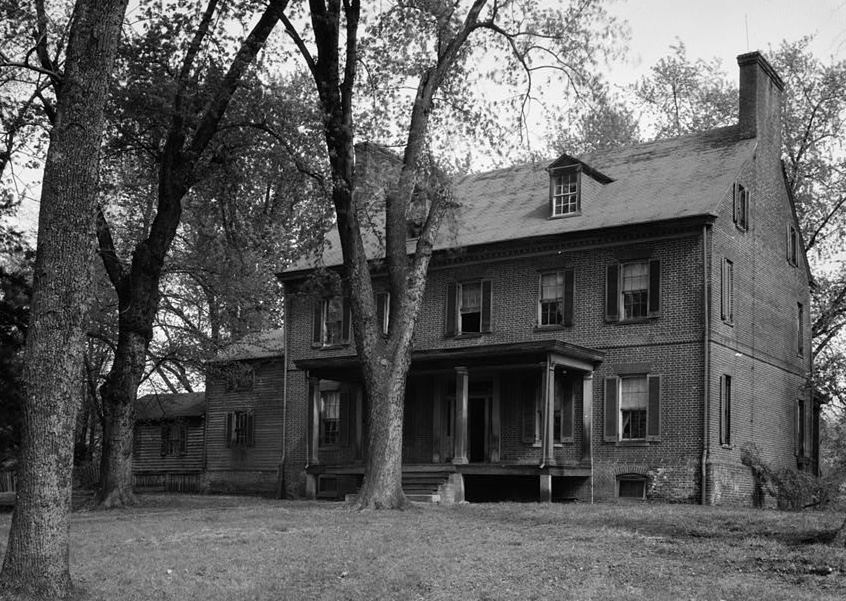
Concord
Monument and historic site · National Register of Historic Places · 1.4 mi
Historic house in District Heights, Maryland, United States

Engine Company 27
Monument and historic site · National Register of Historic Places · 3.4 mi
Fire station in Washington, D.C.

Fairmount Heights Historic District
Monument and historic site · National Register of Historic Places · 2.3 mi
Historic district in Maryland, USA

John Philip Sousa Junior High School
Monument and historic site · National Register of Historic Places · 3.3 mi
Historic school building in Washington, D.C., United States

Nannie Helen Burroughs School
Monument and historic site · National Register of Historic Places · 2.6 mi
Historic school formerly named Trades Hall of National Training School for Women and Girls

Ridgeley School
Monument and historic site · National Register of Historic Places · 2.1 mi
Historic school in Capitol Heights, Maryland, United States

Strand Theater
Monument and historic site · National Register of Historic Places · 2.5 mi
Former movie theater in Washington D.C.

Woodlawn Cemetery
Monument and historic site · National Register of Historic Places · 2.6 mi
Cemetery in Washington, D.C.

Museum Conservation Institute
Museum · 3.2 mi
Center for materials conservation and technical research
Smithsonian Museum Support Center
Museum · 3.2 mi
Smithsonian Institution's museum collections management and research facility

Parks, trails and playgrounds19



7 more on the map.
Restaurants and cafes21

Mi Pueblo By Big Papa
Restaurant · 1.7 mi
Mexican Restaurant in Capitol Heights, MD
4947 Marlboro Pike, Capitol Heights


Burger King
Fast food · Burger · 1.5 mi
5730 Silver Hill Road, Forestville
Mo-Sa 06:00-22:00; Su 07:00-22:00
Chick-fil-A
Fast food · Chicken · 1.6 mi
5502 Silver Hill Road, District Heights
Mo-Sa 06:00-22:00; Su off
Domino's
Fast food · Pizza · 1.1 mi
6254 Central Avenue, Capitol Heights
Mo-Th 10:00-24:00; Fr-Sa 10:00-01:00; Su 10:00-24:00
Domino's
Fast food · Pizza · 1.6 mi
2950 Donnell Drive, District Heights
Mo-Th 10:00-24:00; Fr-Sa 10:00-01:00; Su 10:00-24:00
Dunkin'
Fast food · Donut, Coffee Shop · 1.1 mi
6412 Central Avenue, Capitol Heights
Mo-Fr 05:00-20:00; Sa-Su 06:00-20:00
Dunkin'
Fast food · Donut, Coffee Shop · 1.7 mi
5409 Silver Hill Road, District Heights
Mo-Fr 05:00-20:00; Sa-Su 06:00-20:00
Panda Express
Fast food · Chinese · 1.7 mi
5410 Silver Hill Road, District Heights
Mo-Th 09:30-22:00; Fr 09:30-22:30; Sa 10:00-22:30; Su 10:00-21:30
9 more on the map.
Churches and places of worship34

First Baptist Church of Deanwood
Church · National Register of Historic Places · 3.2 mi
Church in Washington, D.C., United States

Ridgley Methodist Episcopal Church
Church · National Register of Historic Places · 2.5 mi
Church building in Maryland, United States of America


St. Matthew's Church
Church · National Register of Historic Places · 2.2 mi
Church building in Seat Pleasant, United States of America


First Baptist Church of Capitol Heights
Church · Baptist · 1.4 mi
6 Capitol Heights Boulevard, Capitol Heights
Kingdom Hall of Jehovahs Witnesses
Church · Jehovahs Witness · 1.7 mi
8009 Darcy Road, District Heights
New Jerusalem Baptist Church
Church · Baptist
6802 Walker Mill Road, Capitol Heights
Trinidad Baptist Church
Church · Baptist · 0.5 mi
6611 Walker Mill Road, Capitol Heights
Walker Mill Baptist Church
Church · Baptist
6801 Walker Mill Road, Capitol Heights
22 more on the map.
Shopping9
Gas and EV charging9
Schools, colleges and libraries60
Cesar Chavez Public Charter Schools For Public Policy
School · 3.6 mi
3701 Hayes Street Ne, Washington
Elsie Whitlow Stokes Community Freedom Pcs - East End
School · 1.9 mi
5600 East Capitol Street Ne, Washington
Friendship Pcs - Blow Pierce Elementary
School · 4.8 mi
725 19Th Street Ne, Washington
Map of Walker Mill
164 places. The map loads OpenStreetMap tiles when you open it.
Climate by month
Monthly table
| Month | High | Low | Rain | Snow |
|---|---|---|---|---|
| Jan | 45°F | 28°F | 3.0 in | 4.7 in |
| Feb | 48°F | 30°F | 2.8 in | 2.3 in |
| Mar | 56°F | 36°F | 4.0 in | 1.4 in |
| Apr | 68°F | 46°F | 3.4 in | 0.0 in |
| May | 77°F | 57°F | 4.3 in | 0.0 in |
| Jun | 85°F | 66°F | 4.6 in | 0.0 in |
| Jul | 90°F | 71°F | 4.6 in | 0.0 in |
| Aug | 88°F | 69°F | 3.7 in | 0.0 in |
| Sep | 82°F | 62°F | 4.1 in | 0.0 in |
| Oct | 70°F | 49°F | 4.2 in | 0.0 in |
| Nov | 58°F | 39°F | 3.2 in | 0.0 in |
| Dec | 49°F | 32°F | 3.7 in | 1.3 in |
U.S. Climate Normals 1991-2020 for Natl Arboretum Dc (5 mi away), NOAA NCEI.
People and cost of living
American Community Survey 5-year estimates, 2020-2024, U.S. Census Bureau. Estimates have margins of error, larger for small towns.
Disaster history
Prince George's County has had 13 federal disaster declarations since 2000, most often for hurricanes.
- 2026-01-24: Severe Winter Storm (Winter Storm)
- 2020-03-26: Covid-19 Pandemic (Biological)
- 2020-03-13: Covid-19 (Biological)
- 2016-03-04: Severe Winter Storm And Snowstorm (Snowstorm)
- 2012-11-20: Hurricane Sandy (Hurricane)
- 2012-10-28: Hurricane Sandy (Hurricane)
OpenFEMA disaster declarations summaries.
Getting there and nearby towns
Joint Base Andrews (ADW) is the nearest airport with scheduled flights listed in OpenStreetMap, 4 miles away.
- Forestville 2 mi southeast, about 3 min by car
- Suitland 2 mi southwest, about 4 min by car
- Summerfield 3 mi northeast, about 4 min by car
- Landover 4 mi north, about 6 min by car
- Largo 4 mi east, about 6 min by car
- Lake Arbor 4 mi northeast, about 7 min by car
- Camp Springs 5 mi south, about 8 min by car
- Hillcrest Heights 5 mi southwest, about 8 min by car
- Kettering 6 mi east, about 9 min by car
- Washington 7 mi west, about 11 min by car
Drive times are estimates from straight-line distance, not routes.
Local news
Headlines from INDB, the NEMICO news database.
Reviews, tips and questions
Loading what members have shared...
Sources and licences
- NCES EDGE (Public domain): public schools
- NOAA NCEI U.S. Climate Normals 1991-2020 (Public domain): climate by month
- OpenFEMA (Public domain): disaster declarations
- OpenStreetMap contributors (ODbL 1.0): places, airports, map data
- U.S. Census Bureau (Public domain): population, income, housing, education, commute
- Wikidata (CC0 1.0): elevation, founding date, time zone, website, landmarks and historic places
- Wikimedia Commons (see each image): photos
- Wikipedia (CC BY-SA 4.0): overview and history text
Photo credits
- 2016-09-11 12 58 35 View south along Maryland State Route 458 (Walker Mill Road) at Hazelwood Drive in Capitol Heights, Prince Georges County, Maryland, Famartin, CC BY-SA 4.0
- 2020-08-21 10 27 04 View south along Maryland State Route 458 (Silver Hill Road) at Walker Mill Road in Walker Mill, Prince George's County, Maryland, Famartin, CC BY-SA 4.0
- 2016-09-13 11 01 24 View west along Maryland State Route 332 (Central Avenue) at Yolanda Avenue in Walker Mill, Prince George's County, Maryland, Famartin, CC BY-SA 4.0
- Deanwood Old Church, Smallbones, CC0
- Strand Teater DC, Smallbones, CC0
- Engine Company 27 DC, Smallbones, CC0
- Woodlawn Cemetery DC, Smallbones, CC0
- John-phillip-sousa-high-school, Dmadeo, CC BY-SA 3.0
- St Matthews Church Sept 09, Pubdog ( talk ), Public domain
- Ridgley Methodist Episcopal Church Dec 08, Pubdog ( talk ), Public domain
- Trades Hall of National Training School for Women and Girls, Farragutful, CC BY-SA 4.0
- Concord 1936, Historic American Buildings Survey / Historic American Engineering Record, Public domain
- Grace United Methodist Church - Fairmount Heights, Maryland, Farragutful, CC BY-SA 4.0
- Ridgeley Rosenwald School, exterior (21636807881), Preservation Maryland, CC BY-SA 2.0
- Fort Dupont Park December 2017, Eric T. Gunther, CC BY 3.0
- 2018-10-17 15 09 12 View north along Maryland State Route 458 (Silver Hill Road) at Atwood Street and Scott Key Drive in District Heights, Prince George's County, Maryland, Famartin, CC BY-SA 4.0
- 2018-10-17 15 09 31 View south along Maryland State Route 458 (Silver Hill Road) at Atwood Street and Scott Key Drive in District Heights, Prince George's County, Maryland, Famartin, CC BY-SA 4.0
- 2018-10-17 15 06 25 View north along Maryland State Route 458 (Silver Hill Road) just south of Atwood Street and Scott Key Drive in District Heights, Prince George's County, Maryland, Famartin, CC BY-SA 4.0
- Metro tracks over Cabin Branch Road (50056422207), Ben Schumin from Montgomery Village, Maryland, USA, CC BY-SA 2.0
- Train at Addison Road station (50056176566), Ben Schumin from Montgomery Village, Maryland, USA, CC BY-SA 2.0
- Tunnel portal outside Addison Road station (50222856431), Ben Schumin from Montgomery Village, Maryland, USA, CC BY-SA 2.0
- 2018-10-17 15 26 08 View west along Maryland State Route 332 (Central Avenue) at Sultan Avenue and Suffolk Avenue in Capitol Heights, Prince George's County, Maryland, Famartin, CC BY-SA 4.0
- 2016-09-11 13 03 10 View east along Maryland State Route 972 (Old Silver Hill Road) between Parkland Drive and Parkland Court in District Heights, Prince Georges County, Maryland, Famartin, CC BY-SA 4.0
- Cities by a Bay (18189198736), John Leszczynski from Washington, DC, USA, CC BY-SA 2.0
- Sandra Dove Pledges to Pool Safely (34734521844), PoolSafely, CC BY 2.0
- Sandra Dove takes the Pool Safely Pledge (35188502410), PoolSafely, CC BY 2.0
- 2016-09-11 13 02 15 View west along Maryland State Route 972 (Old Silver Hill Road) at Maryland State Route 458 (Silver Hill Road) just west of District Heights in Prince Georges County, Maryland, Famartin, CC BY-SA 4.0
- 2020-08-25 18 22 26 View east along Maryland State Route 458 (Silver Hill Road) at Maryland State Route 4 (Pennsylvania Avenue) in Oakland, Prince George's County, Prince George's County, Maryland, Famartin, CC BY-SA 4.0
- 2019-10-02 13 51 09 View south along Maryland State Route 4 (Pennsylvania Avenue) just north of Maryland State Route 458 (Silver Hill Road) in Suitland, Prince George's County, Maryland, Famartin, CC BY-SA 4.0
- East cornerstone (8733083420), Payton Chung from DCA, USA, CC BY 2.0
- 2018-10-17 15 34 49 View west along Maryland State Route 214 (Central Avenue) just east of Southern Avenue in Capitol Heights, Prince George's County, Maryland, Famartin, CC BY-SA 4.0
- 2018-10-17 15 35 19 View east along Maryland State Route 214 (Central Avenue) at Southern Avenue in Capitol Heights, Prince George's County, Maryland, Famartin, CC BY-SA 4.0
- 2019-10-01 11 38 19 View north along Maryland State Route 4 (Pennsylvania Avenue) just south of Maryland State Route 458 (Silver Hill Road) in Suitland, Prince George's County, Maryland, Famartin, CC BY-SA 4.0
- 2016-09-13 11 06 07 View east along Maryland State Route 332 (Central Avenue) at Southern Avenue, entering Capitol Heights, Prince Georges County, Maryland from Washington, D.C., Famartin, CC BY-SA 4.0
- 2016-09-13 11 07 13 View west along Central Avenue at Southern Avenue, entering Washington, D.C. from Capitol Heights, Prince Georges County, Maryland, Famartin, CC BY-SA 4.0
- 2018-10-17 15 28 41 View east along Maryland State Route 332 (Central Avenue) at Southern Avenue in Capitol Heights, Prince George's County, Maryland, Famartin, CC BY-SA 4.0
- East cornerstone (8731966465), Payton Chung from DCA, USA, CC BY 2.0
- East Corner Washington DC August 2018, Eric T. Gunther, CC BY 3.0


Page built October 30, 2026. Spotted a mistake? Tell us or suggest a place.