


Sharon Hill, Pennsylvania
Sharon Hill is a borough of 6,002 people in Delaware County, Pennsylvania, founded in 1890.
Why visit Sharon Hill
Townapedia lists 20 museums and landmarks, 19 parks and trails, 32 places to eat and 1 attraction in and around town.
Highlights include George C. Platt Bridge, Bartram's Garden, Darby Meeting and Bosacco Park.
July is the warmest month, with average highs of 88°F; January lows average 26°F, and about 23 inches of snow fall in a normal year.
Weather in Sharon Hill
Forecast from the National Weather Service. Full forecast
About Sharon Hill
Sharon Hill is a borough in Delaware County, Pennsylvania, United States. As of the 2020 census, Sharon Hill had a population of 6,014.
From the Wikipedia article Sharon Hill, Pennsylvania (this version), under CC BY-SA 4.0.
Things to do1

George C. Platt Bridge
Bridge · 3.0 mi
Bridge in Philadelphia, Pennsylvania
Museums and landmarks20
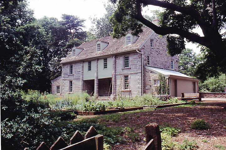
Bartram's Garden
Monument and historic site · National Register of Historic Places · 3.3 mi
Historic house in Pennsylvania, United States

Darby Meeting
Monument and historic site · National Register of Historic Places · 1.0 mi
Historic church in Pennsylvania, United States

Eden Cemetery
Monument and historic site · National Register of Historic Places · 1.1 mi
Cemetery in Collingdale, Pennsylvania, United States

Hardy Williams Academy
Monument and historic site · National Register of Historic Places · 3.2 mi
Charter school in Philadelphia, Pennsylvania

Henry Albertson Subdivision Historic District
Monument and historic site · National Register of Historic Places · 2.5 mi
United States historic place

John Bartram High School
Monument and historic site · National Register of Historic Places · 2.0 mi
High school in Philadelphia, Pennsylvania

John M. Patterson School
Monument and historic site · National Register of Historic Places · 1.7 mi
Public elementary school in Philadelphia, Pennsylvania

Lansdowne Park Historic District
Monument and historic site · National Register of Historic Places · 2.2 mi
Historic district in Pennsylvania, United States

Lansdowne Theatre
Cinema and theater · National Register of Historic Places · 2.2 mi
Theater in Lansdowne, Pennsylvania, United States

Lower Swedish Cabin
Monument and historic site · National Register of Historic Places · 2.4 mi
Building in Pennsylvania, United States

Morton Homestead
Monument and historic site · National Register of Historic Places · 2.9 mi
Building in Pennsylvania, United States


Morton Morton House
Monument and historic site · National Register of Historic Places · 2.2 mi
Historic house in Pennsylvania, United States
8 more on the map.
Parks, trails and playgrounds19


Jack Frazier Memorial Tot Lot
Playground · 1.0 mi
102 Front Street, Colwyn
Mo-Su 08:00-22:30

7 more on the map.
Restaurants and cafes32

Brown Street Cafe
Cafe · American, Brunch · 1.5 mi
2946 Island Avenue, Philadelphia
Tu 08:30-14:00, We-Th 08:30-16:00, Fr-Sa 08:30-16:30

Emma's Liberian Kitchen
Restaurant · 1.4 mi
7201 Woodland Avenue, Philadelphia
Mo 09:00-20:00; Tu-Sa 08:00-20:00; Su 12:00-16:00
JD African Restaurant
Restaurant · African · 0.8 mi
880 Main Street, Darby
Mo-Sa 11:30-21:30
Top Taste
Restaurant · Jamaican · 1.5 mi
7252 Elmwood Avenue, Philadelphia
Keya Graves Seafood & Steaks
Restaurant · Seafood, Steak House · 0.9 mi
10 North 9th Street, Darby

Shotz Bar & Grill
Bar and pub · 1.3 mi
7417 Buist Avenue, Philadelphia
20 more on the map.
Churches and places of worship19
Blessed Virgin Mary Church
Church · Roman Catholic · 1.0 mi
1101 Main Street, Darby
Clearview United Methodist Church
Church · United Methodist · 1.2 mi
7601 Buist Avenue, Philadelphia
Debre Genet Kidus Amannuel Ethiopian Orthodox Tewahedo Church
Church · Ethiopian Orthodox · 1.5 mi
7100 Woodland Avenue, Philadelphia
Mt. Zion United Methodist Church
Church · United Methodist · 0.9 mi
915 Main Street, Darby
New Beginnings Sanctuary of Praise
Church · 1.4 mi
7282 Woodland Avenue, Philadelphia
Shopping11
Gas and EV charging10
Schools, colleges and libraries66
Healthcare11
DaVita Philadelphia West Dialysis
Clinic and pharmacy · 1.5 mi
7609 Lindbergh Boulevard, Philadelphia
Medical Office Building
Clinic and pharmacy · 1.4 mi
1501 South Lansdowne Avenue, Darby
Mercy Eastwick Medical Arts Building
Clinic and pharmacy · 1.4 mi
2801 Island Avenue, Philadelphia
Mercy Wellness Center
Clinic and pharmacy · 1.5 mi
2821 Island Avenue, Philadelphia
Map of Sharon Hill
189 places. The map loads OpenStreetMap tiles when you open it.
Climate by month
Monthly table
| Month | High | Low | Rain | Snow |
|---|---|---|---|---|
| Jan | 41°F | 26°F | 3.1 in | 7.1 in |
| Feb | 44°F | 28°F | 2.8 in | 8.4 in |
| Mar | 53°F | 34°F | 4.0 in | 3.6 in |
| Apr | 65°F | 44°F | 3.5 in | 0.3 in |
| May | 74°F | 54°F | 3.3 in | 0.0 in |
| Jun | 83°F | 64°F | 4.0 in | 0.0 in |
| Jul | 88°F | 70°F | 4.4 in | 0.0 in |
| Aug | 86°F | 68°F | 4.3 in | 0.0 in |
| Sep | 79°F | 61°F | 4.4 in | 0.0 in |
| Oct | 67°F | 49°F | 3.5 in | 0.0 in |
| Nov | 56°F | 39°F | 2.9 in | 0.2 in |
| Dec | 46°F | 31°F | 4.0 in | 3.5 in |
U.S. Climate Normals 1991-2020 for Philadelphia Intl Ap 72408 (3 mi away), NOAA NCEI.
People and cost of living
American Community Survey 5-year estimates, 2020-2024, U.S. Census Bureau. Estimates have margins of error, larger for small towns.
Disaster history
Delaware County has had 15 federal disaster declarations since 2000, most often for hurricanes.
- 2021-09-10: Remnants Of Hurricane Ida (Hurricane)
- 2020-03-30: Covid-19 Pandemic (Biological)
- 2020-03-13: Covid-19 (Biological)
- 2014-02-06: Severe Winter Storm (Severe Ice Storm)
- 2012-10-29: Hurricane Sandy (Hurricane)
- 2011-09-12: Tropical Storm Lee (Flood)
OpenFEMA disaster declarations summaries.
Getting there and nearby towns
Philadelphia International Airport (PHL) is the nearest airport with scheduled flights listed in OpenStreetMap, 2 miles away.
- Collingdale 1 mi northwest, about 1 min by car
- Colwyn 1 mi east, about 1 min by car
- Darby 1 mi north, about 2 min by car
- Glenolden 1 mi southwest, about 2 min by car
- Folcroft 1 mi south, about 2 min by car
- Aldan 1 mi northwest, about 2 min by car
- Yeadon 2 mi northeast, about 3 min by car
- Norwood 2 mi southwest, about 3 min by car
- Clifton Heights 2 mi northwest, about 3 min by car
- Lansdowne 2 mi north, about 4 min by car
Drive times are estimates from straight-line distance, not routes.
Local news
Headlines from INDB, the NEMICO news database.
Reviews, tips and questions
Loading what members have shared...
Sources and licences
- NCES EDGE (Public domain): public schools
- NOAA NCEI U.S. Climate Normals 1991-2020 (Public domain): climate by month
- OpenFEMA (Public domain): disaster declarations
- OpenStreetMap contributors (ODbL 1.0): places, airports, map data
- U.S. Census Bureau (Public domain): population, income, housing, education, commute
- Wikidata (CC0 1.0): elevation, founding date, time zone, website, landmarks and historic places
- Wikimedia Commons (see each image): photos
- Wikipedia (CC BY-SA 4.0): overview and history text
Photo credits
- Rt 102 at Sharon Hill, Danntm, CC BY-SA 3.0
- Sharon Hill, PA Borough Office, Nov. 2025, Mr. Matté (if there is an issue with this image, contact me using this image's Commons talk page , my Commons user talk page , or my English Wikipedia user talk page ; I'll know about it a lot faster), CC BY-SA 4.0
- Former Bethel Gospel Tabernacle Church, Sharon Hill, PA, Nov. 2025, Mr. Matté (if there is an issue with this image, contact me using this image's Commons talk page , my Commons user talk page , or my English Wikipedia user talk page ; I'll know about it a lot faster), CC BY-SA 4.0
- Sharon Hill station from passing train, January 2016, Pi.1415926535, CC BY-SA 3.0
- US 13 sb approaching Barker Avenue, Sharon Hill, PA, Nov. 2025, Mr. Matté (if there is an issue with this image, contact me using this image's Commons talk page , my Commons user talk page , or my English Wikipedia user talk page ; I'll know about it a lot faster), CC BY-SA 4.0
- SEPTA Station Sharon Hill PA, Robert Mortell, CC BY-SA 3.0
- Sharon Avenue nb entering Sharon Hill, PA, Nov. 2025, Mr. Matté (if there is an issue with this image, contact me using this image's Commons talk page , my Commons user talk page , or my English Wikipedia user talk page ; I'll know about it a lot faster), CC BY-SA 4.0
- 2022-10-16 14 53 21 View north along U.S. Route 13 (Chester Pike) at Clifton Avenue in Sharon Hill, Delaware County, Pennsylvania, Famartin, CC BY-SA 4.0
- 2022-10-16 12 37 12 View south along U.S. Route 13 (Chester Pike) just north of Florence Avenue in Sharon Hill, Delaware County, Pennsylvania, Famartin, CC BY-SA 4.0
- Sharon Hill, PA post office, Nov. 2025, Mr. Matté (if there is an issue with this image, contact me using this image's Commons talk page , my Commons user talk page , or my English Wikipedia user talk page ; I'll know about it a lot faster), CC BY-SA 4.0
- US 13 sb approaching High Street, Sharon Hill, PA, Nov. 2025, Mr. Matté (if there is an issue with this image, contact me using this image's Commons talk page , my Commons user talk page , or my English Wikipedia user talk page ; I'll know about it a lot faster), CC BY-SA 4.0
- US 13 sb at Laurel Road and Cherry Street, Sharon Hill, PA, Nov. 2025, Mr. Matté (if there is an issue with this image, contact me using this image's Commons talk page , my Commons user talk page , or my English Wikipedia user talk page ; I'll know about it a lot faster), CC BY-SA 4.0
- SEPTA 106 at Sharon Hill (3), December 2008, Derek Yu, CC BY-SA 2.0
- SEPTA 106 at Sharon Hill (2), December 2008, Derek Yu, CC BY-SA 2.0
- SEPTA 106 at Sharon Hill (1), December 2008, Derek Yu, CC BY-SA 2.0
- Shaw School Philly, Smallbones, Public domain
- MortonMorton House, User:Smallbones on English Wikipedia., Public domain
- Patterson School Philly, Smallbones, Public domain
- TB Read School Philly, Smallbones, Public domain
- Tilden Jr HS 2, Smallbones, Public domain
- Octavius Catto grave, Lblanchard, CC BY-SA 2.0
- Bartram House May 2002c, Jtfry at English Wikipedia, CC BY 3.0
- LowerSwedishCabin, User:Smallbones on English Wikipedia., Public domain
- DarbyMeeting2, Smallbones at en.wikipedia, Public domain
- Turret w house 35 West Lansdowne HD, Smallbones, CC BY-SA 3.0
- LansdowneTheatre, User:Smallbones on English Wikipedia., Public domain
- Albertson 85 Greenway DelCo PA, Smallbones, CC BY-SA 3.0
- 20thCenturyClub, Smallbones at English Wikipedia, Public domain
- Bartram HS Philly, Smallbones, Public domain
- MortonsenCabin, User:Smallbones ., Public domain
- Catherine School SW Philly, Smallbones, Public domain
- Mitchel School Philly, Smallbones, Public domain
- G Wolf School Philly, Smallbones, Public domain
- St. Philomena Lansdown PA, Smallbones, CC0
- Phila Platt Bridge02, Davidt8, Public domain
- Bessie Smith grave, TypoBoy, CC0
- Collingdale, PA Community Center (1), Nov. 2025, Mr. Matté (if there is an issue with this image, contact me using this image's Commons talk page , my Commons user talk page , or my English Wikipedia user talk page ; I'll know about it a lot faster), CC BY-SA 4.0
- Clifton Avenue nb at MacDade Boulevard, Collingdale, PA, Nov. 2025, Mr. Matté (if there is an issue with this image, contact me using this image's Commons talk page , my Commons user talk page , or my English Wikipedia user talk page ; I'll know about it a lot faster), CC BY-SA 4.0
- Sharon Avenue nb, Darby Township, PA, Nov. 2025, Mr. Matté (if there is an issue with this image, contact me using this image's Commons talk page , my Commons user talk page , or my English Wikipedia user talk page ; I'll know about it a lot faster), CC BY-SA 4.0
- Ash Road eb, Darby Township, PA, Nov. 2025, Mr. Matté (if there is an issue with this image, contact me using this image's Commons talk page , my Commons user talk page , or my English Wikipedia user talk page ; I'll know about it a lot faster), CC BY-SA 4.0


Page built October 30, 2026. Spotted a mistake? Tell us or suggest a place.