


Why visit Southgate
Townapedia lists 49 museums and landmarks, 12 parks and trails, 27 places to eat and 13 attractions in and around town.
Highlights include Majestic, Brady Music Center, Bartlett Building and Bavarian Brewing Company.
July is the warmest month, with average highs of 87°F; January lows average 24°F.
Weather in Southgate
Forecast from the National Weather Service. Full forecast
About Southgate
Southgate is a home rule-class city in Campbell County, Kentucky, United States. The population was 3,648 at the 2020 census.
From the Wikipedia article Southgate, Kentucky (this version), under CC BY-SA 4.0.
Things to do13

Majestic
Cinema and theater · National Register of Historic Places · 2.9 mi
Historic showboat now permanently docked in Cincinnati, Ohio, United States
Brady Music Center
Cinema and theater · 3.2 mi
Music venue in Cincinnati, Ohio, United States

Brent Spence Bridge
Bridge · 3.4 mi
Bridge in United States of America
C&O Railroad Bridge
Bridge · 3.2 mi
Railroad bridge spanning the Ohio River at Cincinnati, Ohio, and Covington, Kentucky
Cincinnati–Newport Bridge
Bridge · 2.8 mi
Bridge in Newport, Kentucky

Coney Island
Monument and historic site · 2.8 mi
Water park in Cincinnati, Ohio

Gateway Community and Technical College
School · 2.6 mi
Community college in Covington, Kentucky, U.S.

Newport Aquarium
Zoo and aquarium · 2.5 mi
Aquarium located in Newport, Kentucky, United States
Northern Kentucky University
School · 2.2 mi
Public university in Highland Heights, Kentucky
Pike's Opera House
Cinema and theater · 3.3 mi
Former theater and concert hall in Cincinnati, Ohio, United States
Taft Theatre
Cinema and theater · 3.3 mi
Theater in Cincinnati, Ohio, United States
Taylor–Southgate Bridge
Bridge · 2.7 mi
Bridge in Kentucky and Cincinnati, Ohio
1 more on the map.
Museums and landmarks49

Bartlett Building
Monument and historic site · National Register of Historic Places · 3.3 mi
Building in Cincinnati, Ohio

Bavarian Brewing Company
Monument and historic site · National Register of Historic Places · 2.7 mi
Former brewery and historic brewery building in Covington, Kentucky, USA

Bellevue
Monument and historic site · National Register of Historic Places · 2.5 mi
House in Newport, Kentucky

Carew Tower
Monument and historic site · National Register of Historic Places · 3.4 mi
Skyscraper in Cincinnati, Ohio, United States
Cathedral Basilica of the Assumption
Monument and historic site · National Register of Historic Places · 2.2 mi
Roman Catholic cathedral in the United States

Cincinnati Street Gas Lamps
Monument and historic site · National Register of Historic Places · 2.9 mi
Public street lighting

Daniel Carter Beard Boyhood Home
Monument and historic site · National Register of Historic Places · 2.6 mi
Historic house in Kentucky, United States
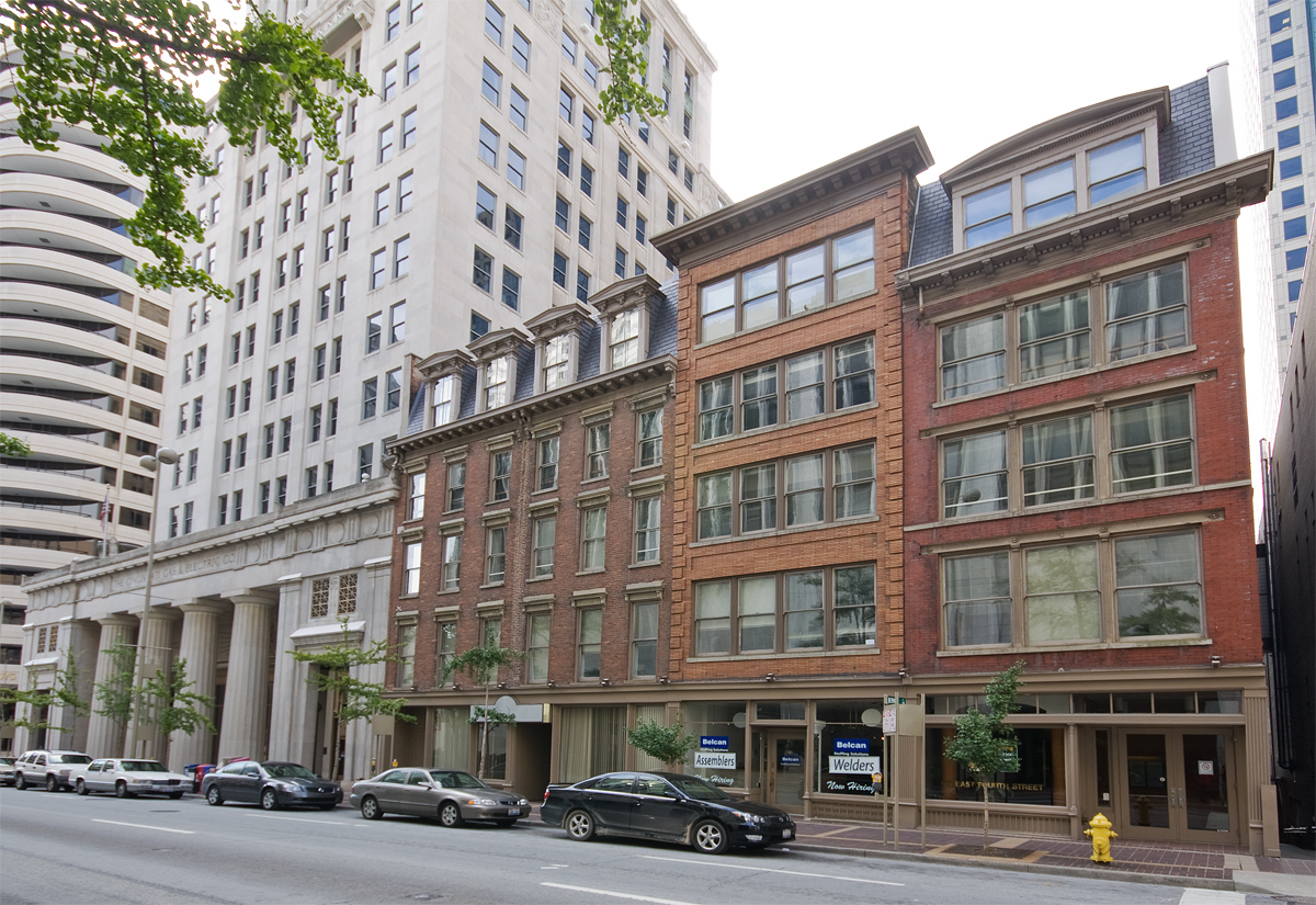
East Fourth Street Historic District
Monument and historic site · National Register of Historic Places · 3.4 mi
Historic district in Ohio, United States

Fenwick Club Annex
Monument and historic site · National Register of Historic Places · 3.2 mi
Arena in Ohio, United States of America

Fifth District School
Monument and historic site · National Register of Historic Places · 2.3 mi
Historic building in Covington, Kentucky


Fourth & Walnut Center
Monument and historic site · National Register of Historic Places · 3.3 mi
Historic building in Cincinnati, Ohio, U.S
Holy Cross Church and School Complex-Latonia
Monument and historic site · National Register of Historic Places · 2.0 mi
Historic church in Kentucky, United States
37 more on the map.
Parks, trails and playgrounds12

General James Taylor Park
Park · 2.5 mi
Urban park in Newport, Kentucky, US

Restaurants and cafes27



El Rio Grande Mexican Resturant
Restaurant · Mexican · 1.5 mi
34 Carothers Road
11:00-21:30

15 more on the map.
History
The city of Southgate is named for the family of Richard Southgate. Born in New York City, Richard Southgate went to Newport from Richmond, Virginia in 1795. In October 1797, he was licensed to practice law in the court of Kentucky and appointed Commonwealth Attorney for Campbell County in 1798. He was State Representative in 1803 and Senator from 1817 to 1821. Richard died in July 1857 at the age of 83. Richard's home still stands on Third Street in Newport. His son William was a congressman from Northern Kentucky.
On May 28, 1977, the Beverly Hills Supper Club in Southgate was engulfed in fire, killing 165 inside.
From the History section of Southgate, Kentucky on Wikipedia, under CC BY-SA 4.0.
Churches and places of worship19
Holy Cross Monastery and Chapel
Church · National Register of Historic Places · 3.3 mi
Immaculata Church
Church · National Register of Historic Places · 3.3 mi
Sacred Heart Church
Church · National Register of Historic Places · 2.7 mi
St. Paul Church
Church · National Register of Historic Places · 3.4 mi
St. Paul's Episcopal Church
Church · National Register of Historic Places · 2.4 mi
Saint John The Baptist Catholic Church
Church · Roman Catholic · 1.4 mi
First Presbyterian Church
Church · Presbyterian · 1.5 mi
220 South Fort Thomas Avenue
Shopping3
Gas and EV charging4
Schools, colleges and libraries44
Campbell County Public Library - Philip N. Carrico Branch
Library · 0.6 mi
1000 Highland Avenue, Fort Thomas
Chapman Vocational Education Center
School · 1.7 mi
25Th And Madison Streets, Covington
Crossroads Elementary School
School · 5.1 mi
475 Crossroads Boulevard, Cold Spring
Donald E. Cline Elementary School
School · 3.7 mi
5586 E Alexandria Dr, Cold Spring
Healthcare4
Cincinnati VA Medical Center-Fort Thomas
Hospital · 1.3 mi
1000 South Fort Thomas Avenue, Fort Thomas
Map of Southgate
175 places. The map loads OpenStreetMap tiles when you open it.
Climate by month
Monthly table
| Month | High | Low | Rain |
|---|---|---|---|
| Jan | 41°F | 24°F | 2.9 in |
| Feb | 45°F | 26°F | 2.8 in |
| Mar | 55°F | 33°F | 3.9 in |
| Apr | 67°F | 42°F | 4.4 in |
| May | 75°F | 53°F | 4.7 in |
| Jun | 83°F | 61°F | 4.6 in |
| Jul | 87°F | 65°F | 4.4 in |
| Aug | 86°F | 64°F | 3.4 in |
| Sep | 80°F | 56°F | 3.1 in |
| Oct | 68°F | 44°F | 3.0 in |
| Nov | 55°F | 34°F | 2.9 in |
| Dec | 45°F | 28°F | 3.3 in |
U.S. Climate Normals 1991-2020 for Cincinnati Lunken Ap (4 mi away), NOAA NCEI.
People and cost of living
American Community Survey 5-year estimates, 2020-2024, U.S. Census Bureau. Estimates have margins of error, larger for small towns.
Disaster history
Campbell County has had 14 federal disaster declarations since 2000, most often for severe storms.
- 2026-01-24: Severe Winter Storm (Winter Storm)
- 2025-04-24: Severe Storms, Straight-Line Winds, Tornadoes, Flooding, Landslides, And Mudslides (Severe Storm)
- 2025-04-03: Severe Storms, Straight-Line Winds, Tornadoes, And Flooding (Severe Storm)
- 2025-02-16: Severe Storms, Straight-Line Winds, Flooding, And Landslides (Severe Storm)
- 2020-03-28: Covid-19 Pandemic (Biological)
- 2020-03-13: Covid-19 (Biological)
OpenFEMA disaster declarations summaries.
Getting there and nearby towns
Lunken Airport (LUK) is the nearest airport with scheduled flights listed in OpenStreetMap, 4 miles away.
- Fort Thomas 1 mi northeast, about 2 min by car
- Newport 2 mi northwest, about 3 min by car
- Highland Heights 2 mi south, about 3 min by car
- Bellevue 3 mi north, about 4 min by car
- Covington 3 mi southwest, about 5 min by car
- Dayton 3 mi north, about 5 min by car
- Park Hills 3 mi west, about 5 min by car
- Fort Wright 4 mi west, about 6 min by car
- Cold Spring 4 mi southeast, about 6 min by car
- Cincinnati 6 mi north, about 9 min by car
Drive times are estimates from straight-line distance, not routes.
Local news
Headlines from INDB, the NEMICO news database.
Reviews, tips and questions
Loading what members have shared...
Sources and licences
- NCES EDGE (Public domain): public schools
- NOAA NCEI U.S. Climate Normals 1991-2020 (Public domain): climate by month
- OpenFEMA (Public domain): disaster declarations
- OpenStreetMap contributors (ODbL 1.0): places, airports, map data
- U.S. Census Bureau (Public domain): population, income, housing, education, commute
- Wikidata (CC0 1.0): elevation, founding date, time zone, website, landmarks and historic places
- Wikimedia Commons (see each image): photos
- Wikipedia (CC BY-SA 4.0): overview and history text
Photo credits
- StAugustineComplex, Photo by Greg Hume ( Greg5030 ), CC BY-SA 3.0
- MutterGottesHistoricDistrict, Photo by Greg Hume ( Greg5030 ), CC BY 3.0
- Marianne Theater in Bellevue, Nyttend, Public domain
- Bellevue in Mansion Hill, Newport, Nyttend, Public domain
- WadsworthElectric, Photo by Greg Hume ( Greg5030 ), CC BY 3.0
- District2PoliceStation, Unknown author, CC BY 3.0
- LaSalette Academy in Covington, Nyttend, Public domain
- StPaulDistrict, Photo by Greg Hume ( Greg5030 ), CC BY 3.0
- Purplepeoplebridge, Sunkorg at en.wikipedia, CC BY-SA 3.0
- HolyCrossMonastery, Photo by Greg Hume ( Greg5030 ), CC BY 3.0
- Literary Club of Cincinnati, Nyttend, Public domain
- St Paul's Episcopal Church Newport, KY 03, Paul Barnes, CC BY-SA 4.0
- Sacred-Heart-Church-Bellevue-KY, Wholtone, Public domain
- ImmaculateConceptionChurch, Photo by Greg Hume ( Greg5030 ), CC BY 3.0
- Third and Garrard in Covington, Nyttend, Public domain
- TaftMuseum, Greg Hume ( User:Greg5030 ), CC BY-SA 2.5
- Main and Third Street Cluster, Nyttend, Public domain
- BavarianBrewing, Photo by Greg Hume ( Greg5030 ), CC BY 3.0
- JohnChurchCompanyBuilding, Photo by Greg Hume ( Greg5030 ), CC BY 3.0
- 123E4LR, Greg Hume, CC BY 3.0
- Daniel Beard Home, C. Bedford Crenshaw, aka Bedford at en.wikipedia, Attribution
- StFrancisXavierChurch frontview, MamaGeek at en.wikipedia, CC BY-SA 3.0
- MotherOfGod, Photo by Greg Hume ( Greg5030 ), CC BY 3.0
- TrinityCovington, Photo by Greg Hume ( Greg5030 ), CC BY 3.0
- Union Trust Building in Cincinnati, Nyttend, Public domain
- Fourth and Walnut Centre, Cincinnati, OH (47221101471), Warren LeMay from Cincinnati, OH, United States, CC0
- Linden Grove Cemetery gate, Bedford at en.wikipedia, Public domain
- York Street Cafe Newport, KY, William R. Benton, CC BY-SA 3.0
- Fenwick Club Annex site, Nyttend, Public domain
- East Row Historic District, Jeff Kubina, CC BY-SA 2.0
- FifthDistrictSchool, Photo by Greg Hume ( Greg5030 ), CC BY 3.0
- LickingRiverside, Photo by Greg Hume ( Greg5030 ), CC BY-SA 3.0
- 2008-10-05 02 The John Roebling Bridge, Adam Sofen from Brooklyn, New York, United States, CC BY 2.0
- OH-Cincinnati 1938 1 Ref, National Archives, Public domain
- OddFellowsHallCovington, Photo by Greg Hume ( Greg5030 ), CC BY-SA 3.0
- Carew Tower, Cincinnati, Ohio, EEJCC, CC BY-SA 4.0
- CincinnatiGasLight, Photo by Greg Hume ( Greg5030 ), CC BY 3.0
- Veteran's Monument in Covington north, The original uploader was Bedford at English Wikipedia ., Public domain
- Monmouth at Eighth in Newport, Nyttend, Public domain
- Lewisburg HD in Covington, Nyttend, Public domain


Page built October 30, 2026. Spotted a mistake? Tell us or suggest a place.