


Why visit Terryville
Townapedia lists 19 museums and landmarks, 7 parks and trails, 8 places to eat, 1 place to stay and 2 attractions in and around town.
Highlights include Thomaston Opera House, Town Hill, East Plymouth Historic District and Beleden House.
July is the warmest month, with average highs of 84°F; January lows average 17°F, and about 39 inches of snow fall in a normal year.
Weather in Terryville
Forecast from the National Weather Service. Full forecast
About Terryville
Terryville is a census-designated place (CDP) in Litchfield County, Connecticut, United States, and is the largest village within the town of Plymouth. As of the 2020 census, Terryville had a population of 5,202. The village is named for Eli Terry Jr., the son of the well-known clockmaker Eli Terry Sr.. Terryville is also home to the Lock Museum of America.
From the Wikipedia article Terryville, Connecticut (this version), under CC BY-SA 4.0.
Things to do2

Thomaston Opera House
Cinema and theater · National Register of Historic Places · 3.5 mi
City hall, theatre and movie theater in Thomaston, Connecticut, United States

Museums and landmarks19

East Plymouth Historic District
Monument and historic site · National Register of Historic Places · 1.2 mi
Plymouth, CT, listed on the NRHP in Connecticut

Beleden House
Monument and historic site · National Register of Historic Places · 3.5 mi
Historic house in Connecticut, United States

Bristol Girls' Club
Monument and historic site · National Register of Historic Places · 3.2 mi
Clubhouse in Bristol, United States of America

Clara T. O'Connell School
Monument and historic site · National Register of Historic Places · 2.8 mi
Historic school building at 122 Park Street in Bristol, Connecticut

Clarence A. Bingham School
Monument and historic site · National Register of Historic Places · 3.1 mi
Historic school building at 3 North Street in Bristol, Connecticut

Endee Manor Historic District
Monument and historic site · National Register of Historic Places · 2.6 mi
Historic district in Connecticut, United States

Federal Hill Historic District
Monument and historic site · National Register of Historic Places · 3.5 mi
Historic district in Bristol, Connecticut, USA

Hose and Hook and Ladder Truck Building
Monument and historic site · National Register of Historic Places · 3.5 mi
Historic fire station in Thomaston, Connecticut, USA

Lock Museum of America
Museum
Industry museum in Terryville, Connecticut
230 Main Street, Terryville;Plymouth

Main Street Historic District
Monument and historic site · National Register of Historic Places · 3.4 mi
Historic area in Bristol, Connecticut, United States

Old Bristol High School
Monument and historic site · National Register of Historic Places · 3.6 mi
School in Connecticut, US
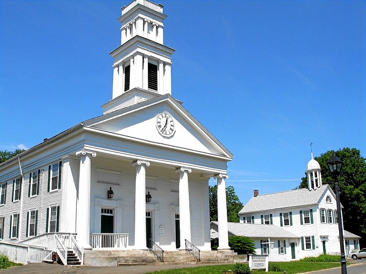
Plymouth Center Historic District
Monument and historic site · National Register of Historic Places · 2.3 mi
Plymouth, CT, listed on the NRHP in Connecticut
7 more on the map.
Parks, trails and playgrounds7


Rockwell Park
Park · National Register of Historic Places · 2.4 mi
Park in Bristol, Hartford County, United States of America



Lake Winfield Recreation Area
Hiking and trails · 1.1 mi
Municipal, Open To Public Without Fee
Restaurants and cafes8

Golden City Restaurant
Restaurant · Chinese · 0.6 mi
311 Main Street, Terryville
Mo-Th 11:00-22:00, Fr,Sa 11:00-23:00, Su 12:00-22:00

Where to stay1
Churches and places of worship5
Trinity Church
Church · National Register of Historic Places · 3.5 mi
Immaculate Conception Roman Catholic Church
Church · Roman Catholic
176 Main Street, Plymouth
Shopping1
Gas and EV charging2
Schools, colleges and libraries30
Bristol Arts And Innovation Magnet School
School · 3.6 mi
70 Memorial Boulevard, Bristol
Healthcare2
Map of Terryville
77 places. The map loads OpenStreetMap tiles when you open it.
Climate by month
Monthly table
| Month | High | Low | Rain | Snow |
|---|---|---|---|---|
| Jan | 36°F | 17°F | 3.6 in | 11.1 in |
| Feb | 39°F | 18°F | 3.4 in | 11.8 in |
| Mar | 47°F | 26°F | 4.2 in | 5.5 in |
| Apr | 60°F | 36°F | 4.3 in | 0.5 in |
| May | 70°F | 47°F | 4.2 in | 0.0 in |
| Jun | 78°F | 57°F | 4.8 in | 0.0 in |
| Jul | 84°F | 62°F | 4.4 in | 0.0 in |
| Aug | 82°F | 60°F | 5.1 in | 0.0 in |
| Sep | 75°F | 52°F | 5.0 in | 0.0 in |
| Oct | 63°F | 41°F | 5.7 in | 0.6 in |
| Nov | 52°F | 32°F | 3.9 in | 0.8 in |
| Dec | 41°F | 24°F | 4.8 in | 8.3 in |
U.S. Climate Normals 1991-2020 for Burlington (9 mi away), NOAA NCEI.
People and cost of living
American Community Survey 5-year estimates, 2020-2024, U.S. Census Bureau. Estimates have margins of error, larger for small towns.
Disaster history
The county has had 23 federal disaster declarations since 2000, most often for hurricanes.
- 2024-09-20: Severe Storm, Flooding, Landslides, And Mudslides (Severe Storm)
- 2024-08-21: Severe Storms, Flooding, Landslides, And Mudslides (Severe Storm)
- 2021-10-30: Remnants Of Hurricane Ida (Hurricane)
- 2021-08-22: Hurricane Henri (Hurricane)
- 2021-01-12: Tropical Storm Isaias (Hurricane)
- 2020-08-06: Tropical Storm Isaias (Hurricane)
OpenFEMA disaster declarations summaries.
Getting there and nearby towns
Waterbury-Oxford Airport (OXC) is the nearest airport with scheduled flights listed in OpenStreetMap, 16 miles away.
- Bristol 3 mi east, about 6 min by car
- Thomaston 4 mi west, about 6 min by car
- Oakville 7 mi southwest, about 12 min by car
- Waterbury 8 mi south, about 13 min by car
- Northwest Harwinton 8 mi northwest, about 12 min by car
- Watertown 8 mi southwest, about 13 min by car
- Plantsville 9 mi southeast, about 14 min by car
- Bethlehem Village 10 mi west, about 17 min by car
- New Britain 11 mi east, about 18 min by car
- Collinsville 11 mi northeast, about 17 min by car
Drive times are estimates from straight-line distance, not routes.
Local news
Headlines from INDB, the NEMICO news database.
Reviews, tips and questions
Loading what members have shared...
Sources and licences
- NCES EDGE (Public domain): public schools
- NOAA NCEI U.S. Climate Normals 1991-2020 (Public domain): climate by month
- OpenFEMA (Public domain): disaster declarations
- OpenStreetMap contributors (ODbL 1.0): places, airports, map data
- U.S. Census Bureau (Public domain): population, income, housing, education, commute
- Wikidata (CC0 1.0): elevation, founding date, time zone, website, landmarks and historic places
- Wikimedia Commons (see each image): photos
- Wikipedia (CC BY-SA 4.0): overview and history text
Photo credits
- Terryville CT 2012, Ken Gallager at English Wikipedia, CC BY-SA 3.0
- Lock Museum of America, Terryville CT, John Phelan, CC BY 4.0
- Terryville Public Library, Terryville CT, John Phelan, CC BY 4.0
- Saint Casimir Church, Terryville CT, John Phelan, CC BY 4.0
- Terryville station and freight house (1), October 2020, Pi.1415926535, CC BY-SA 4.0
- Terryville station and freight house (2), October 2020, Pi.1415926535, CC BY-SA 4.0
- Terryville station and freight house (3), October 2020, Pi.1415926535, CC BY-SA 4.0
- Terryville High School, Terryville CT, John Phelan, CC BY 4.0
- EAST PLYMOUTH HISTORIC DISTRICT, LICHFIELD COUNTY, CT, JERRYE & ROY KLOTZ, M.D., CC BY-SA 4.0
- RockwellParkBristolCT, Jerry Dougherty, CC BY 2.5
- BeledenHouseBristolCT, Jerry Dougherty, CC BY 2.5
- GirlsClubBristolCT, Jerry Dougherty, CC BY 2.5
- BristolCT SouthEndHD 3, Magicpiano, CC BY-SA 4.0
- FirstCongregationalChurchPlymouthCT, Jerry Dougherty, CC BY 2.5
- BristolCT ClarenceBinghamSchool, Magicpiano, CC BY-SA 4.0
- BristolCT ClaraTOConnellSchool, Doug Kerr, CC BY-SA 2.0
- FormerCarberryTheaterBristolCT, Jerry Dougherty, CC BY 2.5
- BristolCT EndeeManorHD 1, Magicpiano, CC BY-SA 4.0
- Thomaston Hose and Hook and Ladder Truck Building 320, Doncram, CC BY-SA 3.0
- Thomaston Opera House 323, Doncram, CC BY-SA 3.0
- Thomaston Trinity Church 319, Doncram, CC BY-SA 3.0
- BristolCT MemorialSchool1, Magicpiano, CC BY-SA 4.0
- AmericanClockAndWatchMuseumBristolCT, Jerry Dougherty, CC BY 2.5
- Waterwheel Terryville CT, Jerry Dougherty, CC BY 2.5
- Witchs Dungeon Classic Movie Museum, Plainville CT, John Phelan, CC BY 4.0
- Bristol Historical Society Museum, Bristol CT, John Phelan, CC BY 4.0
- American Clock and Watch Museum, Bristol CT, John Phelan, CC BY-SA 3.0
- Thomaston station from East Main Street bridge, October 2020, Pi.1415926535, CC BY-SA 4.0
- Greystone Falls, Plymouth, TomVaughn, CC BY-SA 4.0
- Stone structure, Pequabuck CT, John Phelan, CC BY-SA 4.0
- Former coal pocket trestle and Pequabuck River, October 2020, Pi.1415926535, CC BY-SA 4.0
- Wooden trestle over the Pequabuck River, October 2020, Pi.1415926535, CC BY-SA 4.0
- New Departure Branch south of Canal Street, October 2020, Pi.1415926535, CC BY-SA 4.0
- New Departure Branch bridge over Route 72, October 2020, Pi.1415926535, CC BY-SA 4.0
- Post Office, Pequabuck CT, John Phelan, CC BY-SA 4.0
- Plymouth Package, Pequabuck CT, John Phelan, CC BY-SA 4.0
- Pequabuck Golf Club, Pequabuck CT, John Phelan, CC BY-SA 4.0
- East portal of the Pequabuck Tunnel (1), October 2020, Pi.1415926535, CC BY-SA 4.0
- Pequabuck Tunnel interior, October 2020, Pi.1415926535, CC BY-SA 4.0
- View from east portal of Pequabuck Tunnel, October 2020, Pi.1415926535, CC BY-SA 4.0


Page built October 30, 2026. Spotted a mistake? Tell us or suggest a place.