


Why visit İznik
Townapedia lists 31 museums and landmarks, 2 parks and trails, 8 places to eat, 7 places to stay and 1 attraction in and around town.
Highlights include Aureliane and Liada.
Weather in İznik
Forecast from MET Norway (CC BY 4.0). Full forecast
About İznik
İznik (Turkish pronunciation: [izˈnik]) is a municipality and district of Bursa Province, Turkey. Its area is 753 km2, and its population 44,236 (2022). The town is at the site of the ancient city of Nicaea, from which the modern name derives. The town lies in a fertile basin at the eastern end of Lake İznik, with ranges of hills to the north and south.
From the Wikipedia article İznik (this version), under CC BY-SA 4.0.
Travel tips from other travellers: İznik on Wikivoyage (CC BY-SA 4.0).
Things to do1

Museums and landmarks31

Aureliane
Monument and historic site · 7.9 km
Ancient city of Bithynia in modern-day Turkey
Liada
Monument and historic site · 15.3 km
Ancient city of Bithynia in modern-day Turkey

Nicaea
Monument and historic site
Ancient city of Bithynia in modern-day Turkey
Ploketta
Monument and historic site · 5.0 km
Ancient city of Bithynia in modern-day Turkey


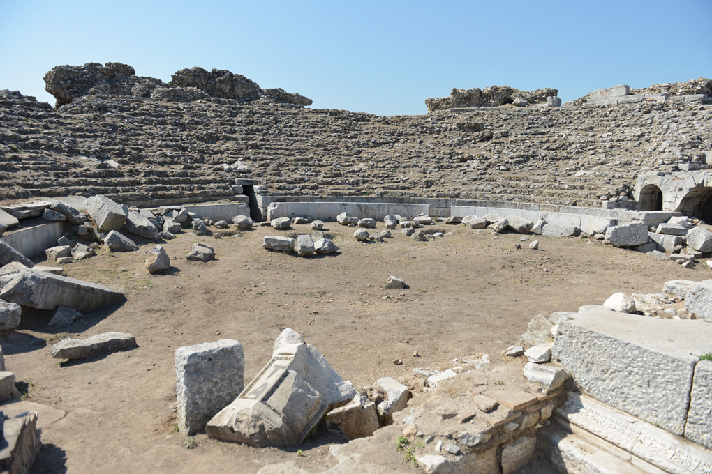

19 more on the map.
Parks, trails and playgrounds2

Restaurants and cafes8

Umut Restaurant
Restaurant · Fish, Turkish · 0.7 km
Göl Sahil Yolu
Open in Google Maps · +905465663717;+902247580022;+905325126354



History
In ancient times, this was the site of Nicaea, a Hellenistic city founded by Antigonus in 316 BC.
In 1331, Orhan captured the city from the Byzantines and for a short period the town became the capital of the expanding Ottoman Emirate. The large church of Hagia Sophia in the centre of the town was converted into the Orhan Mosque and a medrese (theological school-Süleyman Paşa Medresesi) and hamam (bathhouse) were built nearby. In 1334 Orhan built another mosque and an imaret (soup kitchen) just outside the Yenisehir gate (Yenişeh Kapısı) on the south side of the town.
The Moroccan traveller Ibn Battuta stayed in Iznik at the end of 1331 soon after the capture of the town by Orhan. According to Ibn Battuta, the town was in ruins and only inhabited by a small number of people in the service of the sultan. Within the city walls were gardens and cultivated plots with each house surrounded by an orchard. The town produced fruit, walnuts, chestnuts and large sweet grapes.
From the History section of İznik on Wikipedia, under CC BY-SA 4.0.
Where to stay7
Churches and places of worship19
Shopping4
Gas and EV charging8
Schools, colleges and libraries8
Healthcare15
Map of İznik
103 places. The map loads OpenStreetMap tiles when you open it.
Getting there and nearby towns
Bursa Yenişehir Airport (YEI) is the nearest airport with scheduled flights listed in OpenStreetMap, 23 km away.
- Derince 37 km north, about 37 min by car
- İzmit 41 km northeast, about 41 min by car
- İnegol 43 km southwest, about 43 min by car
- Gebze 48 km northwest, about 48 min by car
- Bursa 62 km southwest, about 1 h by car
- Adapazarı 70 km northeast, about 1 h 15 min by car
- Mudanya 71 km west, about 1 h 15 min by car
- Nilüfer 72 km west, about 1 h 15 min by car
- Sancaktepe 76 km northwest, about 1 h 15 min by car
- Ümraniye 82 km northwest, about 1 h 15 min by car
Drive times are estimates from straight-line distance, not routes.
Local news
Headlines from INDB.
Reviews, tips and questions
Loading what members have shared...
Sources and licences
- GeoNames (CC BY 4.0): population, coordinates, regions and time zone
- Mapillary (see each image): photos
- OpenStreetMap contributors (ODbL 1.0): places, airports, map data
- Wikidata (CC0 1.0): elevation, founding date, time zone, website, landmarks and historic places
- Wikimedia Commons (see each image): photos
- Wikipedia (CC BY-SA 4.0): overview and history text
Photo credits
- Iznik 989a, QuartierLatin1968, CC BY-SA 3.0
- Church-Mosque -Museum-İznik (Nicea)Bursa - panoramio, Haluk Comertel, CC BY 3.0
- A fountain in İznik, Kurmanbek, CC BY-SA 4.0
- Interior of Hagia Sophia in İznik, Turkey, Citruswinter, CC0
- Interior of secondary dome in Hagia Sophia in İznik, Turkey, Citruswinter, CC0
- Interior view from entrance of Hagia Sophia in İznik, Turkey, Citruswinter, CC0
- City walls in İznik, Turkey, Citruswinter, CC0
- Front of Hagia Sophia in İznik, Turkey, Citruswinter, CC0
- İznik Ayasofya Camii, Acar54, CC BY-SA 4.0
- İznik Nekropolü 2026-08-29 14.21.40 1789834094, Emirhan Sağdır, CC BY-SA 4.0
- Şeyh Kutbeddin İznikî Türbesi, Mkadioglu2020, CC BY-SA 4.0
- Interior of Green Mosque, İznik 01, Kurmanbek, CC BY-SA 4.0
- Exterior of Green Mosque, İznik 04, Kurmanbek, CC BY-SA 4.0
- İznik Müzesi 2026-08-29 16.40.23 1791293363, Emirhan Sağdır, CC BY-SA 4.0
- İznik Müzesi 2026-09-20 11.54.57 1791807061, Arif miletli, CC BY-SA 4.0
- İznik Müzesi 2026-08-29 16.40.12 1791293376, Emirhan Sağdır, CC BY-SA 4.0
- Nicaea theatre 990, QuartierLatin1968, CC BY-SA 3.0
- Iznik, aya sofia, esterno 01, Francesco Bini, CC BY-SA 4.0
- THE FIRST COUNCIL OF NICEA, Originally uploaded by Coemgenus on en.wikipedia ., Public domain
- Menologion of Basil 024, Authors of Menologion of Basil II (circa 985 AC, Constantinople), Byzantine manuscript illuminators [1] : Pantoleon with Georgios, Michael the Younger, Michael of Blachernae, Symeon, Symeon of..., Public domain
- İznik Yeşil Cami, Acar54, CC BY 2.5
- Iznik Obelisk 01, Kurmanbek, CC BY-SA 4.0
- İznik Roma Tiyatrosu, Yurdanurİznik, CC BY-SA 4.0
- İznik Müzesi 20231030, Basak, CC BY-SA 4.0
- Hagia Sophia Iznik, Elelicht, CC BY-SA 3.0
- Dikilitaş, Beştaş, İznik2, Acar54, CC BY-SA 4.0
- Iznik Theatre 1644, Dosseman, CC BY-SA 4.0
- Cami ve müze, Acar54, CC BY-SA 4.0
- Iznik, aya sofia, esterno 03,0, Francesco Bini, CC BY-SA 4.0
- İZNİK ÇİNİSİ, Volcanicaaa, CC0
- Serie fotografica (Iznik, 1962), Paolo Monti, CC BY-SA 4.0
- Servizio fotografico (Iznik, 1962), Paolo Monti, CC BY-SA 4.0
- Interior of Hagia Sophia, Nicaea in January 2023 01, Kurmanbek, CC BY-SA 4.0
- Exterior of Hagia Sophia, Nicaea in January 2023 02, Kurmanbek, CC BY-SA 4.0
- Exterior of Hagia Sophia, Nicaea in January 2023 01, Kurmanbek, CC BY-SA 4.0
- Interior of Hagia Sophia, Nicaea in January 2023 02, Kurmanbek, CC BY-SA 4.0
- AyasofyaPanorama1, Acar54, CC BY-SA 4.0
- Green Mosque- Iznik - panoramio, Raki_Man, CC BY 3.0
- EşrefoğluRumi, Mkadioglu2020, CC BY-SA 4.0
- Hacı Özbek Camii, Acar54, CC BY-SA 4.0
- Street-level photo, ademturkmen, CC BY-SA 4.0
- Street-level photo, empty, CC BY-SA 4.0
- Street-level photo, empty, CC BY-SA 4.0
- Street-level photo, ademturkmen, CC BY-SA 4.0
- Street-level photo, ademturkmen, CC BY-SA 4.0
- Street-level photo, empty, CC BY-SA 4.0
- Street-level photo, empty, CC BY-SA 4.0
- Street-level photo, ademturkmen, CC BY-SA 4.0
- Street-level photo, ademturkmen, CC BY-SA 4.0
- Street-level photo, ademturkmen, CC BY-SA 4.0
- Street-level photo, kubikanber, CC BY-SA 4.0


Page built November 8, 2026. Spotted a mistake? Tell us or suggest a place.