


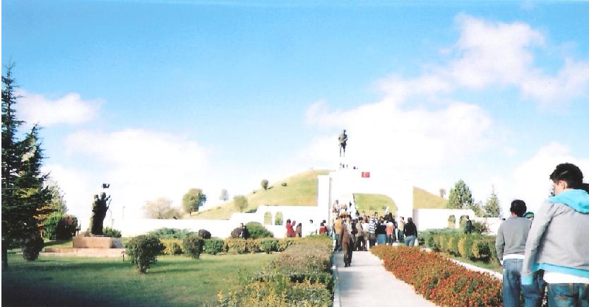


Sinanpaşa, Turkey
Sincanlı
Sinanpaşa is a town of 5,940 people in Afyonkarahisar Province, Turkey.
Why visit Sinanpaşa
Townapedia lists 3 museums and landmarks, 4 parks and trails, 5 places to eat and 5 attractions in and around town.
Highlights include Akçaören Tepe, Great Offensive Martyrs' Cemetery, 26 Ağustos Tabiat Parkı and Commander-in-Chief National Historic Park.
Weather in Sinanpaşa
Forecast from MET Norway (CC BY 4.0). Full forecast
About Sinanpaşa
Sinanpaşa (or Sincanlı) is a town of Afyonkarahisar Province, Turkey on a plain surrounded by pine-covered mountains, 33 km from the city of Afyon on the road to Uşak and İzmir. It is the seat of Sinanpaşa District. Sinanpaşa district has a total population of 38,428 according to the 2024 census, while the town has a population of 3,609 people
From the Wikipedia article Sinanpaşa (this version), under CC BY-SA 4.0.
Things to do5

Museums and landmarks3

Great Offensive Martyrs' Cemetery
Monument and historic site · 13.4 km

Parks, trails and playgrounds4

Commander-in-Chief National Historic Park
Park · 13.5 km
National park in Turkey
Commander-in-Chief National Historic Park
Hiking and trails · 13.8 km

Restaurants and cafes5




History
The area has been a crossroads since antiquity, with archaeological evidence indicating habitation since 4000 BC. Surface excavations in the village of Küçükhöyük go back to 3000 BC.
The name Sinan Paşa comes from the son of a lord of the Akkoyunlu Turks who in 1473 took refuge with Ottoman Sultan Mehmet II during the war between the Akkoyunlu and the warrior Uzun Hasan (the Otlukbeli War). Later in the Ottoman period the important general Hersekzade Ahmet Paşa settled here in the village still known as Ahmet Paşa today.
The town was occupied by Greek forces during the Turkish War of Independence, but was recovered during the great Turkish counter-attack in 1922.
From the History section of Sinanpaşa on Wikipedia, under CC BY-SA 4.0.
Churches and places of worship2
Gas and EV charging16
Healthcare11
Map of Sinanpaşa
46 places. The map loads OpenStreetMap tiles when you open it.
Getting there and nearby towns
17’nci Hava ve Füze Savunma Üs Komutanlığı (AFY) is the nearest airport with scheduled flights listed in OpenStreetMap, 31 km away.
- Afyonkarahisar 26 km east, about 26 min by car
- Sandıklı 31 km south, about 31 min by car
- Banaz 43 km west, about 43 min by car
- Bolvadin 70 km east, about 1 h 15 min by car
- Çay 70 km east, about 1 h 15 min by car
- Uşak 73 km west, about 1 h 15 min by car
- Dinar 76 km south, about 1 h 15 min by car
- Senirkent 76 km south, about 1 h 15 min by car
- Kütahya 79 km north, about 1 h 15 min by car
- Emirdağ 84 km east, about 1 h 30 min by car
Drive times are estimates from straight-line distance, not routes.
Local news
Headlines from INDB.
Reviews, tips and questions
Loading what members have shared...
Sources and licences
- GeoNames (CC BY 4.0): population, coordinates, regions and time zone
- Mapillary (see each image): photos
- OpenStreetMap contributors (ODbL 1.0): places, airports, map data
- Wikidata (CC0 1.0): elevation, founding date, time zone, website, landmarks and historic places
- Wikimedia Commons (see each image): photos
- Wikipedia (CC BY-SA 4.0): overview and history text
Photo credits
- 26 August Nature Park, Mustafacetin03, CC BY-SA 4.0
- Afyon Büyük Taarruz Şehitliği Ve Mustafa Kemal Atatürk Anıtı - Afyonkarahisar, Beshogur, CC BY-SA 4.0
- Dumlupınar Şehitliği, Sabri76, Public domain
- Dumlupınar Şehitliği(2), Sabri76, Public domain
- Gölgedeki güneş, Thesezarr, CC BY-SA 4.0
- ISS027-E-17617 - View of Earth, Earth Science and Remote Sensing Unit , Lyndon B. Johnson Space Center, Public domain
- ISS053-E-149122 - View of Earth, Earth Science and Remote Sensing Unit , Lyndon B. Johnson Space Center, Public domain
- ISS053-E-155269 - View of Earth, Earth Science and Remote Sensing Unit , Lyndon B. Johnson Space Center, Public domain
- ISS022-E-43066 - View of Earth, Earth Science and Remote Sensing Unit , Lyndon B. Johnson Space Center, Public domain
- ISS022-E-43065 - View of Earth, Earth Science and Remote Sensing Unit , Lyndon B. Johnson Space Center, Public domain
- ISS053-E-155270 - View of Earth, Earth Science and Remote Sensing Unit , Lyndon B. Johnson Space Center, Public domain
- ISS050-E-70033 - View of Earth, Earth Science and Remote Sensing Unit , Lyndon B. Johnson Space Center, Public domain
- ISS065-E-81719 - View of Earth, Earth Science and Remote Sensing Unit , Lyndon B. Johnson Space Center, Public domain
- ISS053-E-149123 - View of Earth, Earth Science and Remote Sensing Unit , Lyndon B. Johnson Space Center, Public domain
- ISS053-E-9789 - View of Earth, Earth Science and Remote Sensing Unit , Lyndon B. Johnson Space Center, Public domain
- ISS053-E-149124 - View of Earth, Earth Science and Remote Sensing Unit , Lyndon B. Johnson Space Center, Public domain
- ISS030-E-217802 - View of Earth, Earth Science and Remote Sensing Unit , Lyndon B. Johnson Space Center, Public domain
- ISS027-E-17618 - View of Earth, Earth Science and Remote Sensing Unit , Lyndon B. Johnson Space Center, Public domain
- ISS030-E-217803 - View of Earth, Earth Science and Remote Sensing Unit , Lyndon B. Johnson Space Center, Public domain
- ISS053-E-149125 - View of Earth, Earth Science and Remote Sensing Unit , Lyndon B. Johnson Space Center, Public domain
- ISS030-E-241864 - View of Earth, Earth Science and Remote Sensing Unit , Lyndon B. Johnson Space Center, Public domain
- ISS053-E-155272 - View of Earth, Earth Science and Remote Sensing Unit , Lyndon B. Johnson Space Center, Public domain
- ISS053-E-155271 - View of Earth, Earth Science and Remote Sensing Unit , Lyndon B. Johnson Space Center, Public domain
- ISS030-E-241865 - View of Earth, Earth Science and Remote Sensing Unit , Lyndon B. Johnson Space Center, Public domain
- ISS050-E-70034 - View of Earth, Earth Science and Remote Sensing Unit , Lyndon B. Johnson Space Center, Public domain
- Street-level photo, unen, CC BY-SA 4.0
- Street-level photo, unen, CC BY-SA 4.0
- Street-level photo, unen, CC BY-SA 4.0
- Street-level photo, nazif, CC BY-SA 4.0
- Street-level photo, unen, CC BY-SA 4.0
- Street-level photo, empty, CC BY-SA 4.0
- Street-level photo, nazif, CC BY-SA 4.0
- Street-level photo, nazif, CC BY-SA 4.0
- Street-level photo, nazif, CC BY-SA 4.0
- Street-level photo, nazif, CC BY-SA 4.0
- Street-level photo, empty, CC BY-SA 4.0
- Street-level photo, empty, CC BY-SA 4.0
- Street-level photo, nazif, CC BY-SA 4.0
- Street-level photo, empty, CC BY-SA 4.0
- Street-level photo, nazif, CC BY-SA 4.0
- Street-level photo, empty, CC BY-SA 4.0


Page built November 8, 2026. Spotted a mistake? Tell us or suggest a place.