




West Carson, California
West Carson is a community of 22,143 people in Los Angeles County, California.
Why visit West Carson
Townapedia lists 14 museums and landmarks, 15 parks and trails, 138 places to eat, 2 places to stay and 2 attractions in and around town.
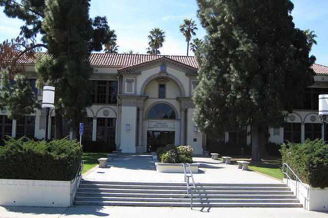
Highlights include Pacific Electric Railroad Bridge, California State University, Dominguez Hills, Auditorium (Torrance High School) and Banning House.
August is the warmest month, with average highs of 78°F; December lows average 46°F.
Weather in West Carson
Forecast from the National Weather Service. Full forecast
About West Carson
West Carson is an unincorporated community in the South Bay region of Los Angeles County, California, United States. The population was 22,870 at the 2020 census. For statistical purposes, the United States Census Bureau has defined West Carson as a census-designated place (CDP).
From the Wikipedia article West Carson, California (this version), under CC BY-SA 4.0.
Things to do2

Pacific Electric Railroad Bridge
Bridge · National Register of Historic Places · 1.4 mi
Railway bridge in Torrance, California, United States

California State University, Dominguez Hills
School · 3.6 mi
University
Museums and landmarks14

Auditorium (Torrance High School)
Monument and historic site · National Register of Historic Places · 1.6 mi
Event venue in Torrance, United States of America

Banning House
Monument and historic site · National Register of Historic Places · 3.1 mi
Historic house in Los Angeles, California

Drum Barracks
Museum · National Register of Historic Places · 3.4 mi
Former military barracks and museum in Wilmington, Los Angeles, California

Fern Elementary School
Monument and historic site · National Register of Historic Places · 2.3 mi
Public elementary school in Torrance, California, United States


Home Economics Building
Monument and historic site · National Register of Historic Places · 1.7 mi
Torrance, California, listed on the NRHP in Los Angeles County, California
Main Building
Monument and historic site · National Register of Historic Places · 1.6 mi
Building in California, United States
Torrance School
Monument and historic site · National Register of Historic Places · 1.5 mi
School building in California, United States of America

Wilmington Branch
Monument and historic site · National Register of Historic Places · 3.2 mi
Former public library in Wilmington, Los Angeles, built in 1927

Lomita Railroad Museum
Museum · 2.2 mi
Railroad museum in Lomita, California
Toyota USA Automobile Museum
Museum · 2.4 mi
Automobile museum in Torrance, California
2 more on the map.
Parks, trails and playgrounds15

Ken Malloy Harbor Regional Park
Park · 2.7 mi
Park in Los Angeles County, California, United States of America

Southern California Live Steamers
Sports field and stadium · 1.6 mi
1200 Washington Avenue, Torrance
Su[1] 11:00-15:00; Sa[3] 12:00-15:00
Janet Shour Pocket Park
Park · 1.4 mi
Playground at Harbor Gateway
Torrance Boulevard, torrance
3 more on the map.
Restaurants and cafes138

85°C
Cafe · Coffee Shop, Chinese · 1.2 mi
1735 West Carson Street
Mo-Th 07:00-21:00; Fr-Sa 07:00-22:00; Su 08:00-21:00

Baekjeong Korean Barbecue
Restaurant · Korean · 1.1 mi
1725 West Carson Street
Mo-Th 11:30-22:00; Fr 11:30-23:00; Sa 11:00-23:00; Su 11:00-22:00
Chinchikurin
Restaurant · Japanese · 1.1 mi
1725 West Carson Street
Mo, We-Fr 11:30-15:00, 17:00-21:00; Sa-Su 11:30-15:00, 16:00-21:00
Haraku
Restaurant · Sushi, Japanese, Seafood · 1.2 mi
1757 West Carson Street, Torrance
Mo-Su 11:30-14:00,17:30-21:00
Hisaya
Cafe · Japanese · 1.2 mi
1757 West Carson Street, Torrance
Su-Th 12:00-21:00; Fr-Sa 12:00-21:30
Ichimi Ann
Restaurant · Japanese · 1.4 mi
1618 Cravens Avenue, Torrance
Su-Fr 11:00-16:00; Sa 11:00-18:00
La Capilla Family Mexican Restaurant
Restaurant · Mexican · 1.4 mi
1332 Sartori Avenue
Mo-Su 11:00-21:00
La Esperanza Restaurant and Bakery
Restaurant · Mexican · 0.9 mi
22832 South Western Avenue
Mo-Fr 09:00-21:00; Sa-Su 08:00-21:00
126 more on the map.
Where to stay2
Churches and places of worship23
Torrance Baptist Temple
Church · Baptist · 1.6 mi
2077 West 236th Street, Torrance
Vietnamese Alliance Church
Church · Christian And Missionary Alliance · 1.5 mi
2051 West 236th Street, Torrance
Shopping10
Gas and EV charging10
Schools, colleges and libraries61
Healthcare9
Map of West Carson
250 places. The map loads OpenStreetMap tiles when you open it.
Climate by month
Monthly table
| Month | High | Low | Rain | Snow |
|---|---|---|---|---|
| Jan | 67°F | 47°F | 3.4 in | 0.0 in |
| Feb | 66°F | 48°F | 3.7 in | 0.0 in |
| Mar | 68°F | 50°F | 2.0 in | 0.0 in |
| Apr | 70°F | 52°F | 0.6 in | 0.0 in |
| May | 72°F | 55°F | 0.3 in | 0.0 in |
| Jun | 74°F | 58°F | 0.1 in | 0.0 in |
| Jul | 77°F | 62°F | 0.1 in | 0.0 in |
| Aug | 78°F | 62°F | 0.0 in | 0.0 in |
| Sep | 78°F | 61°F | 0.1 in | 0.0 in |
| Oct | 76°F | 57°F | 0.5 in | 0.0 in |
| Nov | 71°F | 51°F | 0.8 in | 0.0 in |
| Dec | 66°F | 46°F | 2.2 in | 0.0 in |
U.S. Climate Normals 1991-2020 for Torrance Ap (3 mi away), NOAA NCEI.
People and cost of living
American Community Survey 5-year estimates, 2020-2024, U.S. Census Bureau. Estimates have margins of error, larger for small towns.
Disaster history
Los Angeles County has had 67 federal disaster declarations since 2000, most often for fires.
- 2025-08-08: Canyon Fire (Fire)
- 2025-01-08: Wildfires And Straight-Line Winds (Fire)
- 2025-01-08: Eaton Fire (Fire)
- 2025-01-08: Hurst Fire (Fire)
- 2025-01-07: Palisades Fire (Fire)
- 2024-12-10: Franklin Fire (Fire)
OpenFEMA disaster declarations summaries.
Getting there and nearby towns
Zamperini Field (TOA) is the nearest airport with scheduled flights listed in OpenStreetMap, 3 miles away.
- Lomita 2 mi southwest, about 4 min by car
- Carson 3 mi northeast, about 5 min by car
- Torrance 4 mi west, about 6 min by car
- Gardena 5 mi north, about 8 min by car
- Lawndale 6 mi northwest, about 9 min by car
- Compton 6 mi northeast, about 10 min by car
- West Rancho Dominguez 6 mi north, about 9 min by car
- Redondo Beach 6 mi west, about 10 min by car
- Hawthorne 7 mi northwest, about 11 min by car
- Long Beach 8 mi east, about 13 min by car
Drive times are estimates from straight-line distance, not routes.
Local news
Headlines from INDB, the NEMICO news database.
Reviews, tips and questions
Loading what members have shared...
Sources and licences
- NCES EDGE (Public domain): public schools
- NOAA NCEI U.S. Climate Normals 1991-2020 (Public domain): climate by month
- OpenFEMA (Public domain): disaster declarations
- OpenStreetMap contributors (ODbL 1.0): places, airports, map data
- U.S. Census Bureau (Public domain): population, income, housing, education, commute
- Wikidata (CC0 1.0): elevation, founding date, time zone, website, landmarks and historic places
- Wikimedia Commons (see each image): photos
- Wikipedia (CC BY-SA 4.0): overview and history text
Photo credits
- Harbor-UCLA Medical Center 20150328 (3), Biochemistry2016, CC BY-SA 4.0
- THS HomeEc, Original uploader was Alton at en.wikipedia, CC BY-SA 3.0
- Torrance High School entrance, LCfam, CC BY-SA 3.0
- Banning House, Wilmington, California, Los Angeles, CC BY-SA 3.0
- THS facade, the 216, CC BY 2.0
- 2010-1101-FernAveSchool, Bobak Ha'Eri, CC BY 3.0
- Drum Barracks, Wilmington, California, Los Angeles, CC BY-SA 3.0
- Pacific Electric Railroad Bridge (Torrance), Los Angeles, CC BY-SA 3.0
- Torrance High School Assembly Hall, Los Angeles, CC BY-SA 3.0
- Brown paper bag with happy smiley over head, mistermundo from Torrance, CC BY 2.0
- Lenovo ThinkPad T61, Dingo1234555, CC BY-SA 4.0
- South Bay Los Angeles CA 20220711 (1), Sony 1992, CC0
- South Bay Los Angeles CA 20220711 (239), Sony 1992, CC0
- South Bay Los Angeles CA 20220711 (194), Sony 1992, CC0
- South Bay Los Angeles CA 20220711 (240), Sony 1992, CC0
- South Bay Los Angeles CA 20220711 (83), Sony 1992, CC0
- South Bay Los Angeles CA 20220711 (111), Sony 1992, CC0
- South Bay Los Angeles CA 20220711 (241), Sony 1992, CC0
- South Bay Los Angeles CA 20220711 (87), Sony 1992, CC0
- South Bay Los Angeles CA 20220711 (282), Sony 1992, CC0
- South Bay Los Angeles CA 20220711 (112), Sony 1992, CC0
- South Bay Los Angeles CA 20220711 (105), Sony 1992, CC0
- South Bay Los Angeles CA 20220711 (193), Sony 1992, CC0
- South Bay Los Angeles CA 20220711 (86), Sony 1992, CC0
- South Bay Los Angeles CA 20220711 (85), Sony 1992, CC0
- South Bay Los Angeles CA 20220711 (296), Sony 1992, CC0
- Nissan 300ZX (1991) (53492230453), Charles from Port Chester, New York, CC BY 2.0
- South Bay Los Angeles CA 20220711 (84), Sony 1992, CC0
- South Bay Los Angeles CA 20220711 (283), Sony 1992, CC0
- South Bay Los Angeles CA 20220711 (6), Sony 1992, CC0
- South Bay Los Angeles CA 20220711 (77), Sony 1992, CC0
- South Bay Los Angeles CA 20220711 (64), Sony 1992, CC0
- South Bay Los Angeles CA 20220711 (4), Sony 1992, CC0
- South Bay Los Angeles CA 20220711 (5), Sony 1992, CC0
- South Bay Los Angeles CA 20220711 (94), Sony 1992, CC0
- South Bay Los Angeles CA 20220711 (295), Sony 1992, CC0
- South Bay Los Angeles CA 20220711 (284), Sony 1992, CC0
- South Bay Los Angeles CA 20220711 (290), Sony 1992, CC0
- South Bay Los Angeles CA 20220711 (298), Sony 1992, CC0
- South Bay Los Angeles CA 20220711 (71), Sony 1992, CC0


Page built October 30, 2026. Spotted a mistake? Tell us or suggest a place.