
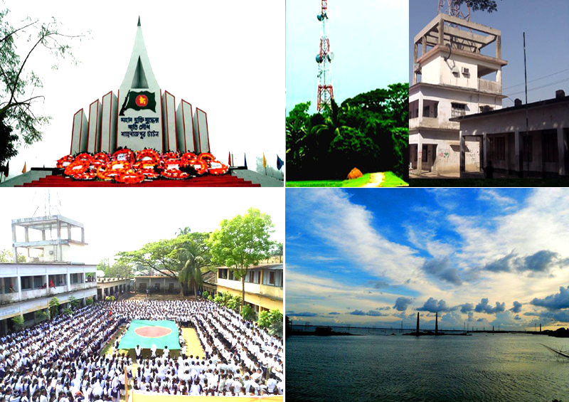


Shāhbāzpur Town, Bangladesh
শাহবাজপুর টাউন
Shāhbāzpur Town is a town of 29,757 people in Chittagong, Bangladesh.
Why visit Shāhbāzpur Town
Townapedia lists 1 museum or landmark, 1 park or trail, 4 places to eat and 1 attraction in and around town.
Highlights include Bariura Old Bridge.
Weather in Shāhbāzpur Town
Forecast from MET Norway (CC BY 4.0). Full forecast
About Shāhbāzpur Town
Shahbazpur is a village in Shahbazpur Union, Sarail Upazila, Brahmanbaria District in the Chittagong Division of eastern Bangladesh.
From the Wikipedia article Shahbazpur, Brahmanbaria (this version), under CC BY-SA 4.0.
Things to do1


Museums and landmarks1

Parks, trails and playgrounds1

Restaurants and cafes4

Churches and places of worship3
Shopping2
Gas and EV charging1
Schools, colleges and libraries1
Map of Shāhbāzpur Town
14 places. The map loads OpenStreetMap tiles when you open it.
Getting there and nearby towns
Maharaja Bir Bikram Airport (IXA) is the nearest airport with scheduled flights listed in OpenStreetMap, 20 km away.
- Brāhmanbāria 11 km southwest, about 11 min by car
- Agartala 26 km southeast, about 26 min by car
- Narsingdi 48 km west, about 48 min by car
- Kishorganj 58 km northwest, about 58 min by car
- Comilla 66 km south, about 1 h by car
- Gazipur 76 km west, about 1 h 15 min by car
- Tungi 80 km west, about 1 h 15 min by car
- Narayanganj 84 km southwest, about 1 h 30 min by car
- Motijheel 85 km southwest, about 1 h 30 min by car
- Dhaka 87 km southwest, about 1 h 30 min by car
Drive times are estimates from straight-line distance, not routes.
Local news
Headlines from INDB.
Reviews, tips and questions
Loading what members have shared...
Sources and licences
- GeoNames (CC BY 4.0): population, coordinates, regions and time zone
- OpenStreetMap contributors (ODbL 1.0): places, airports, map data
- Wikidata (CC0 1.0): elevation, founding date, time zone, website, landmarks and historic places
- Wikimedia Commons (see each image): photos
- Wikipedia (CC BY-SA 4.0): overview and history text
Photo credits
- Shahbazpur Town, Bangladesh., Mishu Rahman, CC BY-SA 3.0
- Mughal Bridge,Bariura, Sarail, BrahmanBaria, Rosepal8, CC BY-SA 4.0
- Bangladesh DSC 0241 (3943508871), Marufish from Alor Setar, Malaysia, CC BY-SA 2.0
- Bangladesh DSC 0240 (3944286904), Marufish from Alor Setar, Malaysia, CC BY-SA 2.0
- Bangladesh DSC 0242 (3943509301), Marufish from Alor Setar, Malaysia, CC BY-SA 2.0
- Bangladesh DSC 0243 (3944288202), Marufish from Alor Setar, Malaysia, CC BY-SA 2.0
- Bangladesh DSC 0245 (3943510513), Marufish from Alor Setar, Malaysia, CC BY-SA 2.0
- Bangladesh DSC 0244 (3943510123), Marufish from Alor Setar, Malaysia, CC BY-SA 2.0
- Bangladesh DSC 0246 (3944289452), Marufish from Alor Setar, Malaysia, CC BY-SA 2.0
- Bangladesh DSC 0237 (3943507959), Marufish from Alor Setar, Malaysia, CC BY-SA 2.0
- Bangladesh DSC 0247 (3943511333), Marufish from Alor Setar, Malaysia, CC BY-SA 2.0
- Bangladesh DSC 0248 (3944290398), Marufish from Alor Setar, Malaysia, CC BY-SA 2.0
- Bangladesh DSC 0236 (3944285894), Marufish from Alor Setar, Malaysia, CC BY-SA 2.0
- Bangladesh DSC 0235 (3944285496), Marufish from Alor Setar, Malaysia, CC BY-SA 2.0
- Bangladesh DSC 0234 (3944285046), Marufish from Alor Setar, Malaysia, CC BY-SA 2.0
- Bangladesh DSC 0233 (3943506013), Marufish from Alor Setar, Malaysia, CC BY-SA 2.0
- Bangladesh DSC 0232 (3943505665), Marufish from Alor Setar, Malaysia, CC BY-SA 2.0
- Bangladesh DSC 0231 (3943505295), Marufish from Alor Setar, Malaysia, CC BY-SA 2.0
- Bangladesh DSC 0230 (3944283342), Marufish from Alor Setar, Malaysia, CC BY-SA 2.0
- Bariura Old Bridge 8, Rosepal8, CC BY-SA 4.0
- Bariura Old Bridge 11, Rosepal8, CC BY-SA 4.0
- Bariura Old Bridge 10, Rosepal8, CC BY-SA 4.0
- Bariura Old Bridge 9, Rosepal8, CC BY-SA 4.0
- Bariura Old Bridge 4, Rosepal8, CC BY-SA 4.0
- Bariura Old Bridge 7, Rosepal8, CC BY-SA 4.0
- Bariura Old Bridge 5, Rosepal8, CC BY-SA 4.0
- Bariura Old Bridge 6, Rosepal8, CC BY-SA 4.0
- Bangladesh DSC 0229 (3943504355), Marufish from Alor Setar, Malaysia, CC BY-SA 2.0
- Bangladesh DSC 0228 (3944282426), Marufish from Alor Setar, Malaysia, CC BY-SA 2.0
- Bangladesh DSC 0227 (3943503321), Marufish from Alor Setar, Malaysia, CC BY-SA 2.0
- Bangladesh DSC 0226 (3943502843), Marufish from Alor Setar, Malaysia, CC BY-SA 2.0
- Bangladesh DSC 0225 (3944281094), Marufish from Alor Setar, Malaysia, CC BY-SA 2.0


Page built November 4, 2026. Spotted a mistake? Tell us or suggest a place.