


Ludwigslust, Germany
Ludwigslust is a town of 12,112 people in Mecklenburg-Vorpommern, Germany, founded in 1765.
Why visit Ludwigslust
Townapedia lists 47 museums and landmarks, 10 parks and trails, 55 places to eat, 9 places to stay and 1 attraction in and around town.
Highlights include Luna Filmtheater, Schloss Ludwigslust, Bahnhof Grabow and Schlosspark Ludwigslust.
Weather in Ludwigslust
Forecast from MET Norway (CC BY 4.0). Full forecast
About Ludwigslust
Ludwigslust (German pronunciation: [luːtvɪçsˈlʊst] ) is a town of Mecklenburg-Vorpommern, in northern Germany, 40 kilometres (25 mi) south of Schwerin. Since 2011 it has been part of the Ludwigslust-Parchim district.
From the Wikipedia article Ludwigslust (this version), under CC BY-SA 4.0.
Things to do1
Museums and landmarks47

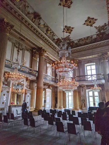
Schloss Ludwigslust
Monument and historic site · 0.6 km
Staatliches Museum Schwerin, Kunstsammlungen, Schlösser und Gärten
4b Schloßfreiheit, Ludwigslust

Bahnhof Grabow
Monument and historic site · 6.4 km
3 Am Bahnhof, Grabow

Hauptmeilenstein Ludwigslust
Monument and historic site
Mecklenburg-Schweriner Hauptmeilenobelisk an der B5, Grabower Allee, Abzweig Techentiner Straße in Ludwigslust.
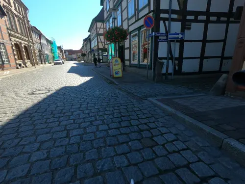
Museum Grabow
Museum · 6.6 km
19 Marktstraße, Grabow
Tu,Fr 09:00-11:00; We,Su,PH 14:00-16:00

Meilenstein
Monument and historic site · 3.2 km
Mecklenburg-Schweriner Halbmeilenobelisk an der B 5 zwischen Kummer und Ludwigslust
Meilenstein
Monument and historic site · 6.6 km
Mecklenburg-Schweriner Ganzmeilenobelisk an der B5 in Kummer
Meilenstein
Monument and historic site · 7.2 km
Mecklenburg-Schweriner Ganzmeilenobelisk an der B 191 bei Güritz

ehemaliges Schloß Grabow
Monument and historic site · 6.9 km
31 Große Straße, Grabow
35 more on the map.
Parks, trails and playgrounds10





Restaurants and cafes55

Hotel Restaurant Stadt Hamburg
Restaurant · German, Regional · 6.8 km
28 Große Straße, Grabow
Mo-Fr 17:00-18:00+; PH,Sa,Su 12:00-14:00,17:00-22:00
Restaurant Athena
Restaurant · Greek
5 Breite Straße, Ludwigslust
Sa,Su 12:00-14:30, Tu-Su 17:30-22:00




Asia Restaurant Family
Restaurant · Chinese
27 Käthe-Kollwitz-Straße, Ludwigslust
43 more on the map.
History
In 1724 Prince Ludwig, the son of Frederick, Duke of Mecklenburg, decided to build a hunting lodge near a small hamlet called Klenow. Later, after his succession to the Dukedom, this became his favorite residence and he named it accordingly Ludwigslust ("Ludwig's pleasure/desire"). In 1765 Ludwigslust became the capital of the duchy in place of Schwerin. The town was enlarged by a residential palace. This situation continued until 1837, when Grand Duke Paul Frederick returned the capital status to Schwerin.
The Wöbbelin concentration camp—sometimes referred to as Ludwigslust concentration camp—was established by the SS near the town of Ludwigslust in 1945. On 10 March 1945, Glaisin (present-day district) was the site of a stopover during the German-organised march of Polish prisoners of war from the Oflag II-D camp to the Stalag X-B camp. In April 1945, prisoners from other subcamps of the Neuengamme concentration camp were brought to Ludwigslust. At the end of World War II, as the Line of contact between Soviet and other Allied forces formed, Ludwigslust was captured by British troops initially, then handed over to American troops. After several months the US troops departed and allowed Soviet troops to enter under the Yalta agreement designating the occupation of Mecklenburg to be administered by the Soviets.
From the History section of Ludwigslust on Wikipedia, under CC BY-SA 4.0.
Where to stay9
Churches and places of worship9
Sankt Helena und Andreas
Church · Roman Catholic · 0.8 km
12 Schloßfreiheit, Ludwigslust
Shopping25
Gas and EV charging10
Schools, colleges and libraries11
Healthcare8
Map of Ludwigslust
185 places. The map loads OpenStreetMap tiles when you open it.
Getting there and nearby towns
Lübeck Airport (LBC) is the nearest airport with scheduled flights listed in OpenStreetMap, 74 km away.
- Parchim 26 km northeast, about 26 min by car
- Schwerin 34 km north, about 34 min by car
- Perleberg 37 km southeast, about 37 min by car
- Wittenberge 40 km southeast, about 40 min by car
- Pritzwalk 49 km southeast, about 49 min by car
- Wismar 63 km north, about 1 h by car
- Mölln 63 km northwest, about 1 h by car
- Ratzeburg 64 km northwest, about 1 h by car
- Lüneburg 72 km west, about 1 h 15 min by car
- Lübeck 81 km northwest, about 1 h 15 min by car
Drive times are estimates from straight-line distance, not routes.
Local news
Headlines from INDB.
Reviews, tips and questions
Loading what members have shared...
Sources and licences
- GeoNames (CC BY 4.0): population, coordinates, regions and time zone
- Mapillary (see each image): photos
- OpenStreetMap contributors (ODbL 1.0): places, airports, map data
- Wikidata (CC0 1.0): elevation, founding date, time zone, website
- Wikimedia Commons (see each image): photos
- Wikipedia (CC BY-SA 4.0): overview and history text
Photo credits
- Ludwigslust Alexandrine Großherzogin von Mecklenburg-Schwerin 05, Hajotthu, CC BY-SA 4.0
- Ludwigslust Alexandrinenplatz 1 Rektorschule 2012-10-21 026, Niteshift, CC BY-SA 3.0
- Ludwigslust Alexandrinenplatz 1 Rektorschule 2012-10-21 024, Niteshift, CC BY-SA 3.0
- Ludwigslust Wappen am Rathaus, Hajotthu, CC BY-SA 4.0
- Ludwigslust Rathaus, Niteshift ( talk ), CC BY 3.0
- Ludwigslust Rathaus Schlossstraße 38 2012-10-21 021, Niteshift, CC BY-SA 3.0
- Ludwigslust Postamt, Niteshift ( talk ), CC BY 3.0
- Ludwigslust Postamt Schlossstraße 41 2012-10-21 022, Niteshift, CC BY-SA 3.0
- Schlossstraße 36 Ludwigslust, Clemensfranz, CC BY-SA 3.0
- Am Bassin in Ludwigslust IMG 1969, Losch, CC BY-SA 3.0 de
- Zinkgussvase im Schlosspark in Ludwigslust IMG 1914, Losch, CC BY-SA 3.0 de
- Natureum in Ludwigslust IMG 1912, Losch, CC BY-SA 3.0 de
- Am Bassin in Ludwigslust IMG 1970, Losch, CC BY-SA 3.0 de
- Louisen-Mausoleum im Schlosspark in Ludwigslust IMG 1932, Losch, CC BY-SA 3.0 de
- Ehemaliges Postgebäude Schloßstraße 1 in Ludwigslust IMG 1987, Losch, CC BY-SA 3.0 de
- Am Bassin in Ludwigslust IMG 1967, Losch, CC BY-SA 3.0 de
- Am Bassin in Ludwigslust IMG 1966, Losch, CC BY-SA 3.0 de
- Schlosspark in Ludwigslust IMG 1959, Losch, CC BY-SA 3.0 de
- Schlossstraße 1 in Ludwigslust IMG 1909, Losch, CC BY-SA 3.0 de
- Am Bassin in Ludwigslust IMG 1968, Losch, CC BY-SA 3.0 de
- Kirche St. Helena im Schlosspark in Ludwigslust IMG 1962, Losch, CC BY-SA 3.0 de
- Louisen-Mausoleum im Schlosspark in Ludwigslust IMG 1931, Losch, CC BY-SA 3.0 de
- Am Bassin in Ludwigslust IMG 1965, Losch, CC BY-SA 3.0 de
- Ludwigslust, Haus Schloßstraße 35, Dguendel, CC BY 4.0
- Ludwigslust, Haus Schloßstraße 29, Dguendel, CC BY 4.0
- Ludwigslust, Haus Kanalstraße 3, Dguendel, CC BY 4.0
- Ludwigslust, Haus Schloßstraße 24, Dguendel, CC BY 4.0
- Ludwigslust Ludwigsluster Kanal Dampffärberei 2012-10-21 013, Niteshift, CC BY-SA 3.0
- Baudenkmal Kanalstraße in Ludwigslust IMG 8687, Losch, CC BY-SA 3.0
- Baudenkmal Kanalstraße in Ludwigslust IMG 8685, Losch, CC BY-SA 3.0
- Ludwigslust mit Frühlinszauber 5, Berlinschneid, CC BY-SA 4.0
- Ludwigslust Kanalstraße 20 Wohnhaus Barca 2012-10-21 012a, Niteshift, CC BY-SA 3.0
- Ludwigslust, Haus Schloßstraße 23, Dguendel, CC BY 4.0
- Ludwigslust Kanalstraße 20 Wohnhaus Barca 2012-10-21 011, Niteshift, CC BY-SA 3.0
- Ludwigslust Kanalstraße 20 Wohnhaus Barca 2012-10-21 010, Niteshift, CC BY-SA 3.0
- Ludwigslust Dampffärberei Brücke Ludwigsluster Kanal 2012-10-21 001, Niteshift, CC BY-SA 3.0
- Ludwigslust Suhrlandthaus 2012-10-21 009a, Niteshift, CC BY-SA 3.0
- Schlossstraße 27 Ludwigslust, Clemensfranz, CC BY-SA 3.0
- Schlossstraße 23 Ludwigslust, Clemensfranz, CC BY-SA 3.0
- Ludwigslust, auf der Schloßstraße, Haus Schloßstraße 27, Dguendel, CC BY 4.0
- SchlossLudwigslust, Frank Maahs, CC BY-SA 3.0
- BahnhofGrabowBahnsteig, Global Fish, CC BY-SA 3.0
- Friedrich-rohr-gymnasium-fullview, Daniel Senff, Public domain
- Grabow Kirche 2008-04-28 136, Niteshift ( talk ), CC BY-SA 3.0
- Ludwigslust Stadtkirche-2, Ludwigslust_Stadtkirche.jpg : Doris Antony , Berlin derivative work: Parzi, CC BY-SA 3.0
- Ludwigslust Schlosspark 4 2013 4, Concord, CC BY-SA 3.0
- Ludwigslust Grabower Allee Hauptmeilenstein B5 2012-07-25 102, Niteshift ( talk ), CC BY-SA 3.0
- St. Helena und St. Andreas (Ludwigslust), Losch (shifted by Rabanus Flavus ), CC BY-SA 3.0
- Ludwigslust Wasserturm Wasserturmweg 2011-09-25 068, Niteshift ( talk ), CC BY-SA 3.0
- Street-level photo, tian, CC BY-SA 4.0
- Street-level photo, u14183, CC BY-SA 4.0
- Street-level photo, hotteliene, CC BY-SA 4.0
- Street-level photo, u14183, CC BY-SA 4.0
- Street-level photo, tobiaso, CC BY-SA 4.0
- Street-level photo, hotteliene, CC BY-SA 4.0
- Street-level photo, tian, CC BY-SA 4.0
- Street-level photo, hotteliene, CC BY-SA 4.0
- Street-level photo, hotteliene, CC BY-SA 4.0
- Street-level photo, km2bp, CC BY-SA 4.0
- Street-level photo, u14183, CC BY-SA 4.0
- Street-level photo, tobiaso, CC BY-SA 4.0
- Street-level photo, Jaschu31311, CC BY-SA 4.0
- Street-level photo, Jaschu31311, CC BY-SA 4.0
- Street-level photo, tian, CC BY-SA 4.0
- Street-level photo, tian, CC BY-SA 4.0
- Street-level photo, tobiaso, CC BY-SA 4.0
- Street-level photo, tobiaso, CC BY-SA 4.0
- Street-level photo, Jaschu31311, CC BY-SA 4.0
- Street-level photo, tian, CC BY-SA 4.0
- Street-level photo, tk79, CC BY-SA 4.0
- Street-level photo, Jaschu31311, CC BY-SA 4.0
- Street-level photo, hotteliene, CC BY-SA 4.0
- Street-level photo, u14183, CC BY-SA 4.0
- Street-level photo, fischtown, CC BY-SA 4.0
- Street-level photo, u14183, CC BY-SA 4.0


Page built November 8, 2026. Spotted a mistake? Tell us or suggest a place.