



Invergowrie, United Kingdom
Invergowrie is a town of 1,770 people in Scotland, United Kingdom.
Why visit Invergowrie
Townapedia lists 40 museums and landmarks, 11 parks and trails, 23 places to eat, 3 places to stay and 3 attractions in and around town.
Highlights include Camperdown Wildlife Centre, Dundee Repertory Theatre, Mills Observatory and Verdant Works Museum.
Weather in Invergowrie
Forecast from MET Norway (CC BY 4.0). Full forecast
About Invergowrie
Invergowrie () is a village on the northwest bank of the Firth of Tay to the west of Dundee. Historically part of Perthshire, it was formerly incorporated as part of the city of Dundee, but is now administered as part of Perth and Kinross.
From the Wikipedia article Invergowrie (this version), under CC BY-SA 4.0.
Photos of Invergowrie


Things to do3

Camperdown Wildlife Centre
Zoo and aquarium · 1.5 mi
Coupar Angus Road, Dundee
Mar-Sep 10:00-16:30; Oct-Feb 10:00-15:30

Dundee Repertory Theatre
Cinema and theater · 3.3 mi
Theatre in Dundee, Scotland

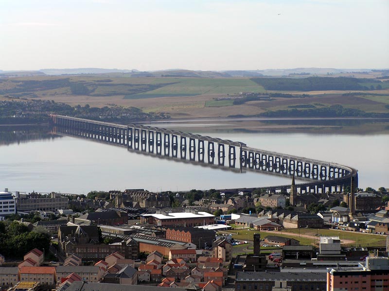
Tay Rail Bridge
Bridge · 3.2 mi
Railway bridge across the River Tay, Scotland
Museums and landmarks40

Mills Observatory
Museum · 1.9 mi
Observatory and museum in Dundee, Scotland, United Kingdom

Verdant Works Museum
Museum · 3.0 mi
Museum in Dundee, Scotland, United Kingdom

Combat City
Monument and historic site · 1.2 mi
Myrekirk Road, Dundee
Mo,Fr 12:00-22:00; We-Th 15:00-22:00

D'Arcy Thompson Zoology Museum
Museum · 3.2 mi
University museum, zoology collection in Dundee , Scotland
28 more on the map.
Parks, trails and playgrounds11

Camperdown Country Park
Park · 1.7 mi
Public park in the Camperdown area of Dundee, Scotland, UK

Restaurants and cafes23
Starbucks
Cafe · Coffee Shop · 0.9 mi
1B Fulton Road, Dundee
Mo-Fr 06:00-22:00; Sa 06:30-22:00; Su 07:00-22:00
Khandy Shop
Cafe · Dessert · 1.5 mi
89 Charleston Drive, Dundee
Su-Th 16:00-23:00; Fr-Sa 16:00-00:00
The Gaiety Bar
Bar and pub · 1.3 mi
Bar and function suite.
Balgarthno Road, Dundee

The Take Away on Level 7
Cafe · 0.8 mi
Ninewells Drive, Dundee
Mo-Fr 07:00-20:30; Sa 08:00-20:00; Su 09:00-20:00


11 more on the map.
History
The old parish church, a roofless 16th century building currently in poor condition, survives on a mound in the old kirkyard, by the Gowrie Burn. This site was formerly close to the sea; much land has been reclaimed from the Firth of Tay in recent times, and it is now some way inland. This was an early Christian site, dedicated to St Curetán. An artistically important and well-preserved cross-slab carved on five faces from this site is on display in the Museum of Scotland in Edinburgh. Dating from the early 9th century, the front shows a cross decorated with interlace, the back three stylised clerics, one holding an object which may be a charter with appended seal, above two dragon-like creatures.
This cross-slab was formerly built into a window of the medieval church, along with another smaller, damaged example, also now in Edinburgh (not on display).
The village was formerly part of the estate of Mylnefield. The quarry at Invergowrie supplied important sites around the UK, stone being included in the base of Nelson's Column and St Katherine's Docks in London. The quarry workers hit a spring at the beginning of the 20th century and the quarry filled with water. The former quarry can be seen as you leave Invergowrie station by train heading to Perth and now looks like a large lake. Until 1967, the main source of work in the village was a paper mill.
Read more of the history
The legend of the Gows o' Gowrie, stones supposed thrown by the devil around Invergowrie. The prophecy comes from a verse by Thomas the Rhymer (circa 1280).
"When the Yowes o' Gowrie come to land,The Day o' Judgement's near at hand"
Where the stones are, if they exist, has not been quite agreed. There is a "Deil's stone" at Greystanes, behind the Hilton hotel, surrounded by a Victorian fence. There is also a lump of rock which used to be called "the Paddock Stone" or the "Fairy Stone" in the wood situated on the Waterside road, near the quarry. It was said another stone was left in Invergowrie Bay, but that is now covered in silt and not visible. The Parish of Longforgan, by Adam Phillips, contains several paragraphs on the subject. The stones are of course glacial deposits. There was also the large Victorian house called "The Gows", now part of the Invergowrie Technology Park.
On 22 October 1979, a rail crash occurred after a warning signal was ignored resulting in the death of five people and 50 injuries.
From the History section of Invergowrie on Wikipedia, under CC BY-SA 4.0.
More about Invergowrie
Geography
Invergowrie is located on the northwest bank of the Firth of Tay, with the Invergowrie Bay located just to the east and south of the village.
The village is included in the Dundee 'settlement' (contiguous built-up area defined by populated postcodes) along with Monifieth on the east side of the city, which similarly to Invergowrie was previously administered as part of Dundee but is now in another local authority area: Angus.
From the Wikipedia article Invergowrie, under CC BY-SA 4.0.
Notable people from Invergowrie
- William Forgan SmithQueensland Premier (1887-1953)
- Adam DavidsonFootballer (1929-2007)
- Charles DonnachieFootballer (1869-1923)
Born in Invergowrie, according to Wikidata (CC0). Each name links to its Wikipedia article.
Where to stay3
Churches and places of worship12
All Souls' Invergowrie Episcopal Church
Church · Scottish Episcopal
Main Street, Dundee
Shopping4
Gas and EV charging6
Schools, colleges and libraries11
Centre for Energy, Petroleum and Mineral Law and Policy
School · 3.2 mi
Robertson Trust Medical Library
Library · 0.9 mi
Ninewells Hospital and Medical School, Dundee
Healthcare3
Map of Invergowrie
116 places. The map loads OpenStreetMap tiles when you open it.
Getting there and nearby towns
Dundee Airport (DND) is the nearest airport with scheduled flights listed in OpenStreetMap, 1 miles away.
- Dundee 3 mi east, about 5 min by car
- Saint Andrews 13 mi southeast, about 21 min by car
- Ladybank 13 mi south, about 21 min by car
- Carnoustie 14 mi east, about 22 min by car
- Forfar 14 mi northeast, about 23 min by car
- Perth 15 mi west, about 24 min by car
- Glenrothes 19 mi south, about 30 min by car
- Arbroath 19 mi east, about 31 min by car
- Methil 19 mi south, about 31 min by car
- Kirkcaldy 24 mi south, about 39 min by car
Drive times are estimates from straight-line distance, not routes.
Towns near Invergowrie


Keep exploring
Local news
Headlines from INDB.
Reviews, tips and questions
Loading what members have shared...
Sources and licences
- GeoNames (CC BY 4.0): population, coordinates, regions and time zone
- Mapillary (see each image): photos
- OpenStreetMap contributors (ODbL 1.0): places, airports, map data
- Wikidata (CC0 1.0): elevation, founding date, time zone, website, landmarks and historic places
- Wikimedia Commons (see each image): photos
- Wikipedia (CC BY-SA 4.0): overview and history text
Photo credits
- Invergowrie2, Macieklew, CC BY 3.0
- Invergowrie railway station 1, Mike Pennington, CC BY-SA 2.0
- Invergowrie rail station, Richard Webb, CC BY-SA 2.0
- Dundee Rep, Ydam, CC BY-SA 3.0
- Taybridge from law 02SEP05, TheCreator, Public domain
- Millsobservtwo, Cyrillic at English Wikipedia, CC BY-SA 3.0
- Verdant, David Hawgood, CC BY-SA 2.0
- Dundee Parish Church, Tunegravity, CC BY-SA 4.0
- Dundee University Scrymgeour, Ydam, CC BY-SA 3.0
- Dundee hospital, Fgioqwerty, CC0
- Ninewells cropped, Ninewells Hospital.jpg : Ydam derivative work: Catfish Jim and the soapdish ( talk ), CC BY-SA 2.5
- Liff Church, Angus, from south-east, R. J. C. Watt, CC BY-SA 4.0
- Rainy day in Scottish village, Maciej Lewandowski from Dundee, Scotland, CC BY-SA 2.0
- Lophura hatinhensis -Camperdown Wildlife Centre, Dundee, Angus, Scotland -pair-8a, Glen Bowman from Newcastle, England, CC BY 2.0
- Street-level photo, gmc, CC BY-SA 4.0
- Street-level photo, southglos, CC BY-SA 4.0
- Street-level photo, hobgoblin, CC BY-SA 4.0
- Street-level photo, southglos, CC BY-SA 4.0
- Street-level photo, hobgoblin, CC BY-SA 4.0
- Street-level photo, hobgoblin, CC BY-SA 4.0
- Street-level photo, hobgoblin, CC BY-SA 4.0
- Street-level photo, hobgoblin, CC BY-SA 4.0
- Street-level photo, southglos, CC BY-SA 4.0
- Street-level photo, hobgoblin, CC BY-SA 4.0
- Street-level photo, hobgoblin, CC BY-SA 4.0
- Street-level photo, hobgoblin, CC BY-SA 4.0
- Street-level photo, hobgoblin, CC BY-SA 4.0
- Street-level photo, hobgoblin, CC BY-SA 4.0
- Street-level photo, hobgoblin, CC BY-SA 4.0
- Street-level photo, southglos, CC BY-SA 4.0
- Street-level photo, hobgoblin, CC BY-SA 4.0


Page built November 10, 2026. Spotted a mistake? Tell us or suggest a place.