


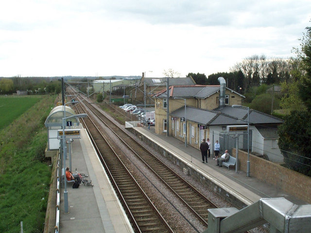

Why visit Meldreth
Townapedia lists 2 museums and landmarks, 9 parks and trails, 12 places to eat and 1 place to stay in and around town.
Highlights include Melbourn War Memorial, Melwood and Melwood Local Nature Reserve.
Weather in Meldreth
Forecast from MET Norway (CC BY 4.0). Full forecast
About Meldreth
Meldreth is a village and civil parish in South Cambridgeshire, England, located around 10 miles (16 km) south-west of Cambridge. At the 2011 Census, the population of the parish was 1,783.
From the Wikipedia article Meldreth (this version), under CC BY-SA 4.0.
Museums and landmarks2
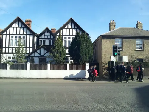

Parks, trails and playgrounds9

Melwood
Park
Melwood is a designated Local Nature Reserve on Cambridgeshire County Council land managed by Melwood Conservation Group volunteers.

Fowlmere RSPB reserve
Park · 1.8 mi
RSPB nature reserve in the United Kingdom



Restaurants and cafes12



Where to stay1

History
A large Bronze Age hoard was found near Meldreth railway station in the nineteenth century that is now in the collections of the British Museum.
The village of Meldreth grew in Saxon times, and the parish is home to Mettle Hill (formerly known as Motlowehyll) that was probably the original meeting place of Armingford Hundred.
Listed as Melrede in the Domesday Book of 1086, the village's name means "mill stream", named after the stream that rises at Melbourn Bury and flows north into the River Rhee. The Domesday Book has nine entries for Meldreth:
Ploughland: 5 ploughlands (land for). 1 lord's plough teams. 4 men's plough teams.
Other resources: 0.5 lord's lands. Meadow 5 ploughs. 2 mills, value 0.53.
Tenant-in-chief and Lord in 1086: Abbey of Ely (St Etheldreda),
Ploughland: 7 ploughlands (land for). 1.5 lord's plough teams. 0.5 lord's plough teams possible. 3 men's plough teams.
Other resources: 1.5 lord's lands. Meadow 5 ploughs. 1 mill, value 0.15.
Tenant-in-chief in 1086: Earl Roger (of Shrewsbury). Lord in 1086: Abbey of Saint-Evroult.
Ploughland: 5 ploughlands (land for). 2 lord's plough teams. 3 men's plough teams.
Tenant-in-chief in 1086: Hardwin of Scales. Lord in 1086: Hugh {Pedefold}.
Other resources: Meadow 2 ploughs. 1 mill, value 0.26. 1 church.
Tenant-in-chief and Lord in 1086: Abbey of Ely (St Etheldreda),
Tenant-in-chief and Lord in 1086: Abbey of Ely (St Etheldreda),
Read more of the history
Tenant-in-chief in 1086: Count Alan (of Brittany). Lord in 1086: Kolsveinn.
Tenant-in-chief and Lord in 1086: Abbey of Ely (St Etheldreda), Lord in 1086: Guy of Raimbeaucourt.
Due to its proximity to Cambridge, much of the land has at some time been owned by colleges of the University of Cambridge. In the early 16th century, Christ's College moved to its Meldreth estate to escape the plague.
In 1952, the Royal Train carrying King George VI's body passed through the station on its journey from Sandringham to London. Residents gathered on the platform to pay their last respects to the King.
The village still has a stocks and whipping post, the traditional medieval punishment, last used in the village in 1860.
From the History section of Meldreth on Wikipedia, under CC BY-SA 4.0.
Churches and places of worship5
Melbourn United Reform Church
Church · United Reformed · 0.9 mi
Orchard Road, Royston
Shopping2
Gas and EV charging1
Schools, colleges and libraries5
Healthcare1
Map of Meldreth
38 places. The map loads OpenStreetMap tiles when you open it.
Getting there and nearby towns
Cambridge City Airport (CBG) is the nearest airport with scheduled flights listed in OpenStreetMap, 11 miles away.
- Royston 3 mi southwest, about 6 min by car
- Orwell 3 mi north, about 5 min by car
- Whittlesford 6 mi east, about 10 min by car
- Cambridge 9 mi northeast, about 14 min by car
- Saffron Walden 11 mi southeast, about 18 min by car
- Baldock 11 mi southwest, about 18 min by car
- Biggleswade 12 mi west, about 19 min by car
- Letchworth Garden City 13 mi southwest, about 20 min by car
- Sandy 13 mi west, about 21 min by car
- Henlow 13 mi west, about 21 min by car
Drive times are estimates from straight-line distance, not routes.
Towns near Meldreth


Keep exploring
Local news
Headlines from INDB.
Reviews, tips and questions
Loading what members have shared...
Sources and licences
- GeoNames (CC BY 4.0): population, coordinates, regions and time zone
- Mapillary (see each image): photos
- OpenStreetMap contributors (ODbL 1.0): places, airports, map data
- Wikidata (CC0 1.0): elevation, founding date, time zone, website, landmarks and historic places
- Wikimedia Commons (see each image): photos
- Wikipedia (CC BY-SA 4.0): overview and history text
Photo credits
- Meldreth - Flickr - XPinger (Chris Sutton) (1), XPinger (Chris Sutton) from Rotorua, New Zealand, CC BY-SA 2.0
- 700118, Meldreth, May 29th 2025 - 55193933028, Southsea_Matt, CC BY-SA 4.0
- 700118, Meldreth, May 29th 2025, Southsea_Matt, CC BY-SA 4.0
- Meldreth station 1905, Unknown author Unknown author, Public domain
- Meldreth Railway Station, Keith Edkins, CC BY-SA 2.0
- Meldreth - Flickr - XPinger (Chris Sutton), XPinger (Chris Sutton) from Rotorua, New Zealand, CC BY-SA 2.0
- Melwood Local Nature Reserve 3, Dudley Miles, CC BY-SA 4.0
- Street-level photo, adam2, CC BY-SA 4.0
- Street-level photo, adam2, CC BY-SA 4.0
- Street-level photo, adam2, CC BY-SA 4.0
- Street-level photo, cyclestreets, CC BY-SA 4.0
- Street-level photo, adam2, CC BY-SA 4.0
- Street-level photo, adam2, CC BY-SA 4.0
- Street-level photo, cyclestreets, CC BY-SA 4.0
- Street-level photo, adam2, CC BY-SA 4.0
- Street-level photo, adam2, CC BY-SA 4.0
- Street-level photo, adam2, CC BY-SA 4.0
- Street-level photo, adam2, CC BY-SA 4.0
- Street-level photo, adam2, CC BY-SA 4.0
- Street-level photo, cyclestreets, CC BY-SA 4.0
- Street-level photo, adam2, CC BY-SA 4.0
- Street-level photo, cyclestreets, CC BY-SA 4.0
- Street-level photo, adam2, CC BY-SA 4.0
Page built November 10, 2026. Spotted a mistake? Tell us or suggest a place.