


Why visit Sherburn
Townapedia lists 16 museums and landmarks, 8 parks and trails, 33 places to eat, 5 places to stay and 5 attractions in and around town.
Highlights include Elvet Bridge, Framwellgate Bridge, Durham Castle and Durham Museum.
Weather in Sherburn
Forecast from MET Norway (CC BY 4.0). Full forecast
About Sherburn
Sherburn, or Sherburn Village, is a village and civil parish in County Durham, England. It is 4 miles east of Durham. In 2011 the parish had a population of 3140.
From the Wikipedia article Sherburn, County Durham (this version), under CC BY-SA 4.0.
Photos of Sherburn

Things to do5

Elvet Bridge
Bridge · 2.7 mi
Grade I listed bridge in Durham, England

Framwellgate Bridge
Bridge · 2.9 mi
Grade I listed bridge in Durham, England

Kingsgate Bridge
Bridge · 2.7 mi
Footbridge across the River Wear in Durham, England

Prebends Bridge
Bridge · 3.0 mi
Grade I listed bridge in Durham, England

The Assembly Rooms Theatre
Cinema and theater · 2.8 mi
Historic theatre in Durham, England
Museums and landmarks16

Durham Castle
Museum · 2.8 mi
Grade I listed historic house museum in Durham, England, UK

Durham Museum
Museum · 2.8 mi
Museum, formerly a church, in Durham, England, United Kingdom

Durham University Museum of Archaeology
Museum · 2.9 mi
Archaeological museum at the University of Durham

Durham University, Oriental Museum
Museum · 3.2 mi
Museum in England, United Kingdom

4 more on the map.
Parks, trails and playgrounds8
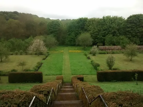
Old Durham Gardens
Park · 2.0 mi
Public gardens in Old Durham, County Durham, England




Restaurants and cafes33
Coffee @ Chesney's
Cafe · Coffee Shop · 1.5 mi
1 Dragonville Court, Durham
Mo-Sa 09:00-17:30; Su 10:00-16:00




21 more on the map.
History
A settlement has existed in this location for some considerable time. Until the 19th century Sherburn was a farming village, but with the Industrial Revolution came the sinking of mines to provide coal to fuel the industries and railways to ensure its distribution. By the 1930s the two pits that were within the Parish boundaries were closed and with the demise of neighbouring collieries in the 1960s the railway lines also became redundant.
In recent years Sherburn Village has become a popular place in which to live, surrounded by countryside and with transport links to the city of Durham, Newcastle upon Tyne, Sunderland and Teesside.
Former Sunderland, Peterborough United and West Bromwich Albion centre-half John Wile was born in Sherburn.
From the History section of Sherburn, County Durham on Wikipedia, under CC BY-SA 4.0.
Notable people from Sherburn
 Josh CharltonBritish cyclistPhoto: Nicola, CC BY-SA 4.0
- Don CowanEnglish footballer (born 1931)
- John WileEnglish footballer-manager (born 1947)
- Samuel StoreyBritish politician
Born in Sherburn, according to Wikidata (CC0). Each name links to its Wikipedia article.
Where to stay5
Churches and places of worship12
Shopping13
Gas and EV charging5
Schools, colleges and libraries11
Healthcare5
Clarks Chemist
Clinic and pharmacy · 1.1 mi
10 Cheveley Park Shopping Centre, Durham
Map of Sherburn
113 places. The map loads OpenStreetMap tiles when you open it.
Getting there and nearby towns
Teesside International Airport (MME) is the nearest airport with scheduled flights listed in OpenStreetMap, 19 miles away.
- Sherburn Hill 1 mi east, about 2 min by car
- Durham 3 mi west, about 5 min by car
- West Rainton 3 mi north, about 5 min by car
- Thornley 3 mi southeast, about 5 min by car
- Hetton-Le-Hole 4 mi northeast, about 6 min by car
- East Rainton 4 mi north, about 6 min by car
- Houghton-Le-Spring 5 mi north, about 8 min by car
- Chester-le-Street 6 mi northwest, about 10 min by car
- Witton Gilbert 6 mi west, about 9 min by car
- Spennymoor 7 mi southwest, about 11 min by car
Drive times are estimates from straight-line distance, not routes.
Towns near Sherburn


Keep exploring
Local news
Headlines from INDB.
Reviews, tips and questions
Loading what members have shared...
Sources and licences
- GeoNames (CC BY 4.0): population, coordinates, regions and time zone
- Mapillary (see each image): photos
- OpenStreetMap contributors (ODbL 1.0): places, airports, map data
- Wikidata (CC0 1.0): elevation, founding date, time zone, website, landmarks and historic places
- Wikimedia Commons (see each image): photos
- Wikipedia (CC BY-SA 4.0): overview and history text
Photo credits
- Durham - Elvet Bridge, Benjamin Smith, CC BY-SA 4.0
- Durham - Framwellgate bridge - 3, Benjamin Smith, CC BY-SA 4.0
- Durham City 30c 20031207 Prebends Bridge 02a, PeterGHughes at English Wikipedia, CC BY 2.5
- North Bailey, Durham (2021-05-27) 24, Simon Cobb, CC0
- Durham Castle, April 2017 (14) (33459522640), Carla Brain, CC BY-SA 2.0
- Durham Heritage Centre, User:Jungpionier (assumed), CC BY-SA 3.0
- Durham Union Palace Green, Uli Harder, CC BY-SA 2.5
- At Durham 2025 097 - St Oswald's Church, Photograph by Mike Peel ( www.mikepeel.net )., CC BY-SA 4.0
- St Giles Church, Gilesgate, Durham, Carol Bleasdale, CC BY-SA 2.0
- Durham - St Nicholas Church - 1, Benjamin Smith, CC BY-SA 4.0
- Durham - Castle - 02, Benjamin Smith, CC BY-SA 4.0
- Sherburn Hospital Chapel Doorway, Chc08rm Raminder Mulla, CC BY-SA 3.0
- Sherburn Hospital Chapel Full View, Chc08rm, CC BY-SA 3.0
- Palace Green Library 2, Durham, Dylan Moore, CC BY-SA 2.0
- Kingsgate Bridge - view of deck from W, Tom Parnell, CC BY-SA 4.0
- Street-level photo, stevenhorner, CC BY-SA 4.0
- Street-level photo, livingwithdragons, CC BY-SA 4.0
- Street-level photo, stevenhorner, CC BY-SA 4.0
- Street-level photo, stevenhorner, CC BY-SA 4.0
- Street-level photo, stevenhorner, CC BY-SA 4.0
- Street-level photo, pluckystructure, CC BY-SA 4.0
- Street-level photo, livingwithdragons, CC BY-SA 4.0
- Street-level photo, livingwithdragons, CC BY-SA 4.0
- Street-level photo, stevenhorner, CC BY-SA 4.0
- Street-level photo, livingwithdragons, CC BY-SA 4.0
- Street-level photo, livingwithdragons, CC BY-SA 4.0
- Street-level photo, livingwithdragons, CC BY-SA 4.0
- Street-level photo, stevenhorner, CC BY-SA 4.0


Page built November 10, 2026. Spotted a mistake? Tell us or suggest a place.