
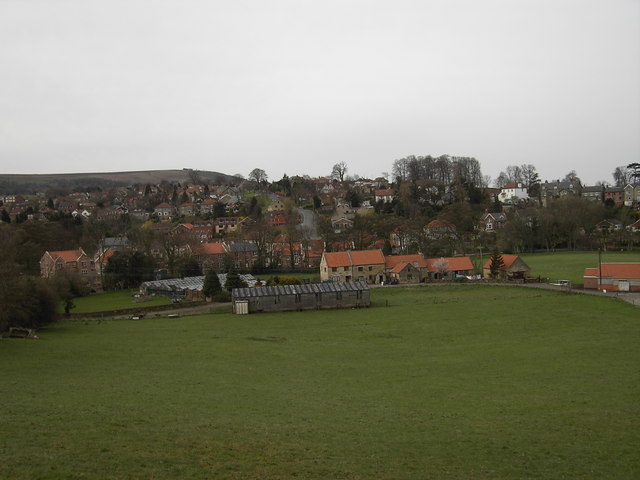


Why visit Sleights
Townapedia lists 7 museums and landmarks, 1 park or trail, 8 places to eat and 8 attractions in and around town.
Highlights include Falling Foss, Grosmont Bridge, Captain Cook Museum Whitby and Whitby Abbey.
Weather in Sleights
Forecast from MET Norway (CC BY 4.0). Full forecast
About Sleights
Sleights is a village in North Yorkshire, England. Located in the Esk Valley to the south-west of Whitby, the village is part of the civil parish of Eskdaleside cum Ugglebarnby. Sleights lies along the steep main A169 road that runs north to south between Whitby and Malton via Pickering across the North York Moors.
From the Wikipedia article Sleights (this version), under CC BY-SA 4.0.
Things to do8

Falling Foss
Waterfall · 2.8 mi
Waterfall in North Yorkshire, England, UK

Grosmont Bridge
Bridge · 2.9 mi
Bridge in Grosmont, Scarborough, North Yorkshire, England, UK

Whitby East Pier Lighthouse
Lighthouse · 3.4 mi
Lighthouse in Whitby, Scarborough, North Yorkshire, England, UK

North York Moors Railway Bridge Across The Murk Esk
Bridge · 2.8 mi
Railway bridge in Grosmont, Scarborough, North Yorkshire, England, UK

Whitby Pavilion
Cinema and theater · 3.0 mi
Theatre in Whitby, England

Whitby West Pier beacon
Lighthouse · 3.4 mi
Lighthouse built 1914 in Whitby
Whitby West Pier Lighthouse
Lighthouse · 3.3 mi
Lighthouse in Whitby, Scarborough, North Yorkshire, England, UK
Museums and landmarks7

Captain Cook Museum Whitby
Museum · 3.1 mi
Grade I listed historic house museum in Whitby, United Kingdom


Whitby Museum
Museum · 2.7 mi
Museum in North Yorkshire, England, United Kingdom

Pannett Art Gallery
Museum · 2.7 mi
Art gallery and museum in Whitby, North Yorkshire, England, United Kingdom

Whale Bone Arch
Monument and historic site · 3.1 mi
Arch in Whitby, North Yorkshire, England, UK
Parks, trails and playgrounds1

Restaurants and cafes8




More about Sleights
Education
The village contains only one school, Sleights Church of England primary school. The school has approximately 100 pupils and is graded as Good by Ofsted and SIAMS (2019). Students aged over 11 years old travel to nearby schools in Whitby.
From the Wikipedia article Sleights, under CC BY-SA 4.0.
Notable people from Sleights
- Edward SimpsonBritish geologist and forger (born 1815)
- John Richardsoncricketer for Yorkshire from the United Kingdom (1908-1985)
Born in Sleights, according to Wikidata (CC0). Each name links to its Wikipedia article.
Churches and places of worship18
Schools, colleges and libraries1
Sleights Church of England Voluntary Controlled Primary School
School · Anglican
Ingham Close, Whitby
Map of Sleights
43 places. The map loads OpenStreetMap tiles when you open it.
Getting there and nearby towns
Teesside International Airport (MME) is the nearest airport with scheduled flights listed in OpenStreetMap, 31 miles away.
- Whitby 3 mi northeast, about 5 min by car
- Danby 10 mi west, about 16 min by car
- Skinningrove 12 mi northwest, about 20 min by car
- Burniston 13 mi southeast, about 20 min by car
- Lingdale 13 mi northwest, about 21 min by car
- Boosbeck 14 mi northwest, about 23 min by car
- Thornton Dale 15 mi south, about 25 min by car
- Scarborough 16 mi southeast, about 26 min by car
- Guisborough 17 mi west, about 27 min by car
- Ingleby Greenhow 18 mi west, about 29 min by car
Drive times are estimates from straight-line distance, not routes.
Towns near Sleights


Keep exploring
Local news
Headlines from INDB.
Reviews, tips and questions
Loading what members have shared...
Sources and licences
- GeoNames (CC BY 4.0): population, coordinates, regions and time zone
- Mapillary (see each image): photos
- OpenStreetMap contributors (ODbL 1.0): places, airports, map data
- Wikidata (CC0 1.0): elevation, founding date, time zone, website, landmarks and historic places
- Wikimedia Commons (see each image): photos
- Wikipedia (CC BY-SA 4.0): overview and history text
Photo credits
- Sleights Cricket Club, Darren Haddock, CC BY-SA 2.0
- Grosmont Bridge, Peter Broster, CC BY-SA 4.0
- Whitby - East Pier Lighthouse, Benjamin Smith, CC BY-SA 4.0
- Whitby - Captain Cook Memorial Museum, Benjamin Smith, CC BY-SA 4.0
- Whitby Abbey (ruins) 2013-09-04 11-25-09, aude, CC BY-SA 3.0
- Whitby museum, Geni, CC BY-SA 4.0
- Whitby - St Mary's Church - 1, Benjamin Smith, CC BY-SA 4.0
- St Hildas Church Sneaton 1 (Nigel Coates), Nigel Coates ( talk ), CC BY-SA 3.0
- Church of St Hilda 2013-09-05 08-39-05, aude, CC BY-SA 3.0
- St Johns Church Sleights 1 (Nigel Coates), Nigel Coates ( talk ), CC BY-SA 3.0
- St Matthew's church, JackoGibbo, CC BY-SA 4.0
- St Ninian's Church, Whitby, The joy of all things, CC BY-SA 4.0
- Falling Foss, North Yorkshire (50350129817), Thomas Tolkien from Yorkshire, UK, CC BY 2.0
- Street-level photo, southglos, CC BY-SA 4.0
- Street-level photo, lamaar639, CC BY-SA 4.0
- Street-level photo, usingsogiving, CC BY-SA 4.0
- Street-level photo, southglos, CC BY-SA 4.0
- Street-level photo, lamaar639, CC BY-SA 4.0
- Street-level photo, lamaar639, CC BY-SA 4.0
- Street-level photo, lamaar639, CC BY-SA 4.0
- Street-level photo, lamaar639, CC BY-SA 4.0
- Street-level photo, lamaar639, CC BY-SA 4.0


Page built November 10, 2026. Spotted a mistake? Tell us or suggest a place.