


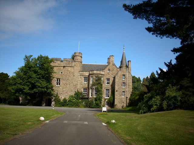

Whitecraig, United Kingdom
Whitecraig is a town of 1,200 people in Scotland, United Kingdom.
Why visit Whitecraig
Townapedia lists 16 museums and landmarks, 11 parks and trails, 17 places to eat, 4 places to stay and 1 attraction in and around town.
Highlights include Brunton Theatre, Prestongrange Museum, Elginhaugh and Inveresk Lodge Garden.
Weather in Whitecraig
Forecast from MET Norway (CC BY 4.0). Full forecast
About Whitecraig
Whitecraig is a village in East Lothian, Scotland. It lies between Musselburgh and Dalkeith, to the east of the city of Edinburgh. In 2022 it had a population of 1330.
From the Wikipedia article Whitecraig (this version), under CC BY-SA 4.0.
Photos of Whitecraig

Things to do1

Brunton Theatre
Cinema and theater · 1.8 mi
Theatre in Musselburgh, Scotland
Museums and landmarks16

Prestongrange Museum
Museum · 3.0 mi
Industry museum in Prestongrange, Scotland, United Kingdom

Elginhaugh
Monument and historic site · 2.4 mi
Archaeological site in Midlothian, Scotland, UK
Inveresk Roman Fort
Monument and historic site · 1.3 mi
Ancient Roman structure in East Lothian, Scotland, UK
4 more on the map.
Parks, trails and playgrounds11




Restaurants and cafes17
La Bella Italia
Restaurant · Italian · 1.4 mi
9 Stoneybank Terrace, Musselburgh




5 more on the map.
Where to stay4
Churches and places of worship3
Shopping4
Gas and EV charging3
Schools, colleges and libraries11
Healthcare1
Map of Whitecraig
71 places. The map loads OpenStreetMap tiles when you open it.
Getting there and nearby towns
Edinburgh Airport (EDI) is the nearest airport with scheduled flights listed in OpenStreetMap, 12 miles away.
- Musselburgh 2 mi north, about 3 min by car
- Dalkeith 2 mi southwest, about 3 min by car
- Mayfield 3 mi south, about 5 min by car
- Tranent 4 mi northeast, about 6 min by car
- Bonnyrigg 4 mi southwest, about 6 min by car
- Edinburgh 6 mi west, about 10 min by car
- Bilston 6 mi southwest, about 10 min by car
- Roslin 7 mi southwest, about 10 min by car
- Penicuik 9 mi southwest, about 15 min by car
- Aberlady 9 mi northeast, about 15 min by car
Drive times are estimates from straight-line distance, not routes.
Towns near Whitecraig


Keep exploring
Local news
Headlines from INDB.
Reviews, tips and questions
Loading what members have shared...
Sources and licences
- GeoNames (CC BY 4.0): population, coordinates, regions and time zone
- Mapillary (see each image): photos
- OpenStreetMap contributors (ODbL 1.0): places, airports, map data
- Wikidata (CC0 1.0): elevation, founding date, time zone, website, landmarks and historic places
- Wikimedia Commons (see each image): photos
- Wikipedia (CC BY-SA 4.0): overview and history text
Photo credits
- Brunton Theatre, Musselburgh (15842992781), John Lord from Edinburgh, Scotland, CC BY 2.0
- Prestongrange windinggear, Renata ( talk ), Public domain
- St. David's Roman Catholic Church, Dalkeith by Owen Proudfoot, Owen Proudfoot, CC BY-SA 2.0
- Queen Margaret University main building, Stuart Caie from Edinburgh, Scotland, CC BY 2.0
- Carberry Tower(2), Jimmydenham, Public domain
- DSCN7669 Musselburgh Grammar School, AlasdairW, CC BY-SA 4.0
- COA Musselburgh GS, Gemini, Public domain
- DSCN7665 Inveresk Lodge Garden, AlasdairW, CC BY-SA 4.0
- Street-level photo, lucagm, CC BY-SA 4.0
- Street-level photo, lucagm, CC BY-SA 4.0
- Street-level photo, rudolfmayer, CC BY-SA 4.0
- Street-level photo, smsm1, CC BY-SA 4.0
- Street-level photo, smsm1, CC BY-SA 4.0
- Street-level photo, lucagm, CC BY-SA 4.0
- Street-level photo, victuallers, CC BY-SA 4.0
- Street-level photo, lucagm, CC BY-SA 4.0
- Street-level photo, lucagm, CC BY-SA 4.0
- Street-level photo, lucagm, CC BY-SA 4.0
- Street-level photo, southglos, CC BY-SA 4.0
Page built November 10, 2026. Spotted a mistake? Tell us or suggest a place.