


Hillcrest, New York
Hillcrest is a community of 9,071 people in Rockland County, New York.
Why visit Hillcrest
Townapedia lists 4 museums and landmarks, 5 parks and trails, 3 places to eat, 1 place to stay and 1 attraction in and around town.
Highlights include Yeshiva Zichron Yaakov, Houser-Conklin House, North Main Street School and Fairway Park.
Weather in Hillcrest
Forecast from the National Weather Service. Full forecast
About Hillcrest
Hillcrest is a hamlet incorporated in 1893 and census-designated place, in the town of Ramapo, Rockland County, New York, United States. It is located north of Spring Valley, east of Viola, south of New Square and New Hempstead, and west of New City. The population was 8,164 at the 2020 census.
From the Wikipedia article Hillcrest, Rockland County, New York (this version), under CC BY-SA 4.0.
Things to do1

Yeshiva Zichron Yaakov
School · 1.3 mi
All-male Jewish Orthodox high school located in New Hempstead, New York
Museums and landmarks4

Houser-Conklin House
Monument and historic site · National Register of Historic Places · 1.7 mi
Historic house in New York, United States

North Main Street School
Monument and historic site · National Register of Historic Places · 0.8 mi
School building in New York, United States of America
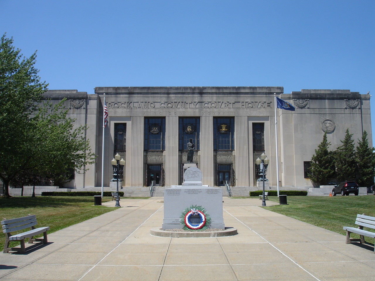
Rockland County Courthouse and Dutch Gardens
Monument and historic site · National Register of Historic Places · 2.6 mi
Historic district in New York, United States of America


United States Post Office
Monument and historic site · National Register of Historic Places · 1.3 mi
Government building in Spring Valley, New York
Parks, trails and playgrounds5



Restaurants and cafes3



Popeyes
Fast food · Chicken · 1.5 mi
175 Route 59, Spring Valley
Mo-Th 10:30-22:00; Fr-Sa 10:30-23:00; Su 10:30-22:00
History
In the early 1900s, Hillcrest became a summer retreat for working-class families from New York City; the families could access Hillcrest by train from New Jersey (after ferrying across to the western shore of the Hudson). In 1955, the Tappan Zee Bridge opened (connecting Tarrytown in Westchester County with Nyack in Rockland County), increasing traffic into the community and making access to New York City easier for the local population. Along with many other communities in the lower Hudson Valley, Hillcrest became a destination for White Flight from New York City in the 1950s through 1970s. Craig H. Long, the Town of Ramapo historian, said that many secular Jews were part of the first wave of settlers into Hillcrest after the opening of the Tappan Zee. In the 1960s, Hillcrest attracted Jews from the boroughs of Brooklyn and The Bronx in New York City; the Jewish people going to Hillcrest desired inexpensive starter homes, a short commute and a suburban atmosphere.
From the History section of Hillcrest, Rockland County, New York on Wikipedia, under CC BY-SA 4.0.
Where to stay1
Churches and places of worship33
Brick Church Complex
Church · National Register of Historic Places · 1.7 mi
New Hempstead Presbyterian Church
Church · National Register of Historic Places · 1.4 mi
St. Paul's Episcopal Church
Church · National Register of Historic Places · 1.6 mi
Saint John the Baptist Orthodox Church
Church · Orthodox · 1.4 mi
64 West Church Street, Spring Valley
nikelshburg ניקלשברג
Place of worship · Hasidic · 1.4 mi
6 Milton Place, Spring Valley
Shopping5
Gas and EV charging4
Schools, colleges and libraries46
Clarkstown South Senior High School
School · 3.4 mi
31 Demarest Mill Rd, West Nyack
Edith A. Bogert Elementary School
School · 5.8 mi
391 W Saddle River Rd, Upper Saddle River
Emil A. Cavallini Middle School
School · 5.7 mi
392 W Saddle River Rd, Upper Saddle River
Healthcare1
Map of Hillcrest
103 places. The map loads OpenStreetMap tiles when you open it.
People and cost of living
American Community Survey 5-year estimates, 2020-2024, U.S. Census Bureau. Estimates have margins of error, larger for small towns.
Disaster history
Rockland County has had 20 federal disaster declarations since 2000, most often for hurricanes.
- 2023-07-22: Severe Storms And Flooding (Severe Storm)
- 2021-09-05: Remnants Of Hurricane Ida (Hurricane)
- 2021-09-02: Remnants Of Hurricane Ida (Hurricane)
- 2021-08-22: Hurricane Henri (Hurricane)
- 2020-10-02: Tropical Storm Isaias (Hurricane)
- 2020-03-20: Covid-19 Pandemic (Biological)
OpenFEMA disaster declarations summaries.
Getting there and nearby towns
Westchester County Airport (HPN) is the nearest airport with scheduled flights listed in OpenStreetMap, 17 miles away.
- Spring Valley 1 mi southwest, about 2 min by car
- Monsey 3 mi southwest, about 4 min by car
- Nanuet 3 mi southeast, about 4 min by car
- New City 3 mi northeast, about 4 min by car
- Chestnut Ridge 3 mi south, about 5 min by car
- Bardonia 3 mi east, about 5 min by car
- Airmont 4 mi southwest, about 6 min by car
- Pearl River 5 mi south, about 8 min by car
- Congers 5 mi east, about 8 min by car
- Montvale 5 mi south, about 8 min by car
Drive times are estimates from straight-line distance, not routes.
Local news
Headlines from INDB, the NEMICO news database.
Reviews, tips and questions
Loading what members have shared...
Sources and licences
- NCES EDGE (Public domain): public schools
- OpenFEMA (Public domain): disaster declarations
- OpenStreetMap contributors (ODbL 1.0): places, airports, map data
- U.S. Census Bureau (Public domain): population, income, housing, education, commute
- Wikidata (CC0 1.0): elevation, founding date, time zone, website, landmarks and historic places
- Wikimedia Commons (see each image): photos
- Wikipedia (CC BY-SA 4.0): overview and history text
Photo credits
- Hillcrest Fire Company No. 1, Hillcrest, NY, Jan. 2025, Mr. Matté (if there is an issue with this image, contact me using this image's Commons talk page , my Commons user talk page , or my English Wikipedia user talk page ; I'll know about it a lot faster), CC BY-SA 4.0
- New Hempstead Presbyterian Church, New City, NY, Daniel Case, CC BY-SA 3.0
- ST. PAUL'S EPISCOPAL CHURCH, Spring Valley, New York, JERRYE AND ROY KLOTZ, M.D., CC BY-SA 4.0
- Brick Church, Jimstu8, CC BY-SA 3.0
- North Main Street School, Spring Valley, NY, Daniel Case, CC BY-SA 3.0
- HOUSER-CONKLIN HOUSE, MONSEY, ROCKLAND COUNTY, NY, JERRYE & ROY KLOTZ. M.D., CC BY-SA 4.0
- Spring Valley, NY, post office, Daniel Case, CC BY-SA 3.0
- RocklandCountyCourthouse, KForce, CC BY-SA 3.0
- Church at Novo-Diveevo, Violette79 from Brooklyn, NY, USA, CC BY-SA 2.0
- New Hope Christian Church, Pwdennis2, CC BY-SA 3.0
- NY Route 45 nb entering New Hempstead, Jan. 2025, Mr. Matté (if there is an issue with this image, contact me using this image's Commons talk page , my Commons user talk page , or my English Wikipedia user talk page ; I'll know about it a lot faster), CC BY-SA 4.0
- St. Joseph Church, Spring Valley, NY, Jan. 2025, Mr. Matté (if there is an issue with this image, contact me using this image's Commons talk page , my Commons user talk page , or my English Wikipedia user talk page ; I'll know about it a lot faster), CC BY-SA 4.0
- Spring Valley, NY shopping center and village offices, Jan. 2025, Mr. Matté (if there is an issue with this image, contact me using this image's Commons talk page , my Commons user talk page , or my English Wikipedia user talk page ; I'll know about it a lot faster), CC BY-SA 4.0
- New York National Guard Hurricane Sandy Response (Image 5 of 5) (8157922021), DVIDSHUB, CC BY 2.0
- Salvation Army building, Spring Valley, NY, Jan. 2025, Mr. Matté (if there is an issue with this image, contact me using this image's Commons talk page , my Commons user talk page , or my English Wikipedia user talk page ; I'll know about it a lot faster), CC BY-SA 4.0
- Rabbi Chaim Yehoshua Halberstam Satmar Monsey Rav With Woodridge Rebbe, Shimon2519, CC0
- Entrance to Spring Valley, NY, Sije, CC BY-SA 4.0
- Rockland Hook & Ladder, Spring Valley, NY, Jan. 2025, Mr. Matté (if there is an issue with this image, contact me using this image's Commons talk page , my Commons user talk page , or my English Wikipedia user talk page ; I'll know about it a lot faster), CC BY-SA 4.0
- Hanukkah lighting of Zvhiller Rebbe of Monsey 2, Adamreinman, CC BY-SA 4.0
- Hanukkah lighting of Zvhiller Rebbe of Monsey, Adamreinman, CC BY-SA 4.0
- Town of Ramapo Cultural Arts Center 2023 jeh, Jim.henderson, CC BY-SA 4.0
- Русское кладбище в Ново-Дивееве (13370834835), Dennis from New York, USA, CC BY-SA 2.0
- Русское кладбище в Ново-Дивееве (13370976463), Dennis from New York, USA, CC BY-SA 2.0
- Русское кладбище в Ново-Дивееве (13371262954), Dennis from New York, USA, CC BY-SA 2.0
- Русское кладбище в Ново-Дивееве (13371216454), Dennis from New York, USA, CC BY-SA 2.0
- Русское кладбище в Ново-Дивееве (13370844475), Dennis from New York, USA, CC BY-SA 2.0
- Русское кладбище в Ново-Дивееве (13370830965), Dennis from New York, USA, CC BY-SA 2.0
- Русское кладбище в Ново-Дивееве (13370889235), Dennis from New York, USA, CC BY-SA 2.0
- Русское кладбище в Ново-Дивееве (13371267684), Dennis from New York, USA, CC BY-SA 2.0
- Русское кладбище в Ново-Дивееве (13371032003), Dennis from New York, USA, CC BY-SA 2.0
- Русское кладбище в Ново-Дивееве (13370847425), Dennis from New York, USA, CC BY-SA 2.0
- Русское кладбище в Ново-Дивееве (13370898655), Dennis from New York, USA, CC BY-SA 2.0
- Русское кладбище в Ново-Дивееве (13370988893), Dennis from New York, USA, CC BY-SA 2.0
- Русское кладбище в Ново-Дивееве (13370902015), Dennis from New York, USA, CC BY-SA 2.0
- Русское кладбище в Ново-Дивееве (13370826565), Dennis from New York, USA, CC BY-SA 2.0
- Русское кладбище в Ново-Дивееве (13370992043), Dennis from New York, USA, CC BY-SA 2.0
- Русское кладбище в Ново-Дивееве (13370962683), Dennis from New York, USA, CC BY-SA 2.0
- Русское кладбище в Ново-Дивееве (13419616745), Dennis from New York, USA, CC BY-SA 2.0
- Русское кладбище в Ново-Дивееве (13370855625), Dennis from New York, USA, CC BY-SA 2.0
- Русское кладбище в Ново-Дивееве (13371198644), Dennis from New York, USA, CC BY-SA 2.0


Page built October 30, 2026. Spotted a mistake? Tell us or suggest a place.