




Why visit Dharmadam
Townapedia lists 2 museums and landmarks, 15 parks and trails, 25 places to eat, 16 places to stay and 2 attractions in and around town.
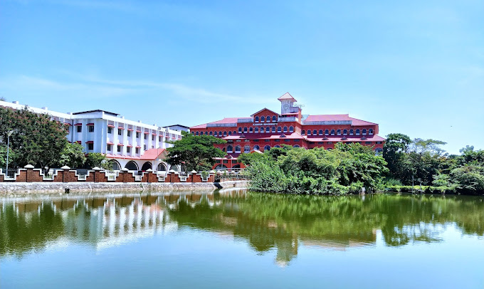
Highlights include Kannur University, Muzhappilangad Beach, Gundert Museum and Overbury's Folly.
Weather in Dharmadam
Forecast from MET Norway (CC BY 4.0). Full forecast
About Dharmadam
Dharmadom or Dharmadam is a Census Town in Kannur district in the state of Kerala, India. This town is located in between Anjarakandi River and Ummanchira River, and Palayad town and Arabian Sea. It is known for the 100-year-old Government Brennen College, Dharmadam Island, and the famous Muzhappilangad beach.
From the Wikipedia article Dharmadom (this version), under CC BY-SA 4.0.
Things to do2
Kannur University
School · 2.4 km
State public university in Kannur, Kerala, India

Muzhappilangad Beach
Beach · 3.0 km
Beach in Kannur district, Keralam, India
Museums and landmarks2


Parks, trails and playgrounds15




Sreerosh play time
Playground · 2.5 km
Mo-Fr 09:00-18:30; Sa 09:00-17:00; PH closed


3 more on the map.
Restaurants and cafes25

Restaurent
Restaurant · Indian, Coffee Shop, Curry, Crepe · 2.3 km
Mo-Fr 09:00-18:30; Sa 09:00-17:00; PH closed
Josgiri Canteen
Restaurant · Indian, Coffee Shop, Curry, Fish And Chips · 2.4 km
Mo-Fr 09:00-12:00,13:30-18:30; Sa 09:00-17:00; closed
Kerala State Road Transport Coporation Canteen
Restaurant · 2.5 km
corona vayal road
Mo,Tu,Th,Fr 09:00-18:30; We 09:00-20:00; Sa 09:00-17:00; PH closed
Restaaurent
Restaurant · Barbecue, Chicken, Fish, Curry, Coffee Shop, Indian · 2.2 km
Mo-Fr 09:00-18:30; Sa 09:00-17:00; PH closed
Savoury
Restaurant · Sandwich, Indian, Coffee Shop, Curry, Fish, Chicken, Barbecue, Arab, Chinese, Ice Cream, Sausage, Seafood · 3.0 km
Mo-Fr 09:00-18:30; Sa 09:00-17:00; PH closed


Daily Icecreams
Ice cream · 2.4 km
Mo-Fr 09:00-12:00,13:30-18:30; Sa 09:00-17:00; PH closed
13 more on the map.
History
Dharmadom is a scenic coastal town that was earlier known as "Dharmapattanam". It was an active Buddhist area in ancient times. Arabs called it as Darmaftan.
Dharmadom is also home to famous Andalurkavu temple. The annual festival here draws thousands of devotees. A variety of Theyyam is performed at this event.
India’s premier circus Academy, Circus Academy Thalassery is also located in Dharmadom.
Dharmadom was selected as location for the prominent British Thalassery fort that was built in 1703 but landowners did not want to sell the land.
According to Qissat Shakarwati Farmad, a mosque was built in Dharmadam during the era of Malik Dinar.
The island of Dharmapattanam was claimed by all of the Kolattu Rajas, Kottayam Rajas, and Arakkal Bibi in the late medieval period. The island of Dharmadam was ceded to the East India Company in 1734, along with Thalassery.
From the History section of Dharmadom on Wikipedia, under CC BY-SA 4.0.
Where to stay16
Churches and places of worship33
Shopping8
Schools, colleges and libraries46
DIET Lab School Palayad
School · 1.2 km
Chirakkuni-Station Road, Thalessery South ,Kannur
Angel Nursery And Upper Primary School
School · 3.2 km
Kulam Bazar,Kadavu Road, Kannur South,Kannur
Healthcare14
Primary Health Centre Dharmadam
Hospital · 0.7 km
Dharmadam-Meloor-mamakunnu road
Map of Dharmadam
161 places. The map loads OpenStreetMap tiles when you open it.
Getting there and nearby towns
Kannur International Airport (CNN) is the nearest airport with scheduled flights listed in OpenStreetMap, 18 km away.
- Muluppilagadu 3 km northwest, about 3 min by car
- Tellicherry 4 km southeast, about 4 min by car
- Mahē 11 km southeast, about 11 min by car
- Panoor 13 km east, about 13 min by car
- Mattanur 21 km northeast, about 21 min by car
- Nādāpuram 23 km southeast, about 23 min by car
- Pāppinisshēri 24 km northwest, about 24 min by car
- Irikkūr 25 km north, about 25 min by car
- Taliparamba 32 km north, about 32 min by car
- Kozhikode 68 km southeast, about 1 h 15 min by car
Drive times are estimates from straight-line distance, not routes.
Local news
Headlines from INDB.
Reviews, tips and questions
Loading what members have shared...
Sources and licences
- GeoNames (CC BY 4.0): population, coordinates, regions and time zone
- OpenStreetMap contributors (ODbL 1.0): places, airports, map data
- Wikidata (CC0 1.0): elevation, founding date, time zone, website, landmarks and historic places
- Wikimedia Commons (see each image): photos
- Wikipedia (CC BY-SA 4.0): overview and history text
Photo credits
- Dharmadom railway station, Vinayaraj, CC BY-SA 3.0
- Dharmadam Mangroves and estuaries, kannur . kerala - panoramio, Suresh Babunair, CC BY 3.0
- Muzhappilangad beach12, Ajeeshkumar4u, CC BY-SA 4.0
- Kannur Univerisity Thavakkara Campus, Rahul B Ashok, CC0
- Overbury's foly, Akhil chandran, CC BY-SA 3.0
- Hermann Gundert bungalow, Jameela P., CC BY-SA 4.0
- In harmony with nature, Anusri7, CC BY-SA 4.0
- Sunset Palayad, Bijilkolari, CC BY-SA 4.0
- Flowers of Avicennia officinalis, Shagil Kannur, CC BY-SA 4.0
- Fishermen at work by Shagil Kannur, Shagil Kannur, CC BY-SA 4.0
- NTTF Tellichery, Vaikoovery, CC BY 3.0
- Hermann Gundert1, Jameela P., CC BY-SA 4.0
- Anjarakkandi River, Shagil Kannur, CC BY-SA 4.0
- Kerala village footpath, Shagil Kannur, CC BY-SA 4.0
- Lesser crested terns at Muzhappilangad beach, Shagil Kannur, CC BY-SA 4.0
- Pandanus Canaranus - Fruit, Shagil Kannur, CC BY-SA 4.0
- Pandanus Canaranus - Fruit 2, Shagil Kannur, CC BY-SA 4.0
- Pandanus Canaranus - Fruit 3, Shagil Kannur, CC BY-SA 4.0
- Muzhappilangad Beach 2, Shagil Kannur, CC BY-SA 4.0
- Pandanus Canaranus - Fruit 4, Shagil Kannur, CC BY-SA 4.0
- Pandanus Canaranus - Fruit 5, Shagil Kannur, CC BY-SA 4.0
- Pandanus Canaranus - Fruit 6, Shagil Kannur, CC BY-SA 4.0
- Thalassery, Kerala, India - panoramio, Dinesh K.M, CC BY-SA 3.0
- 1 Nadan parippvada, kannur, kerala, Anjusha C, CC BY-SA 4.0
- Artocarpus altilis 3, Shagil Kannur, CC BY-SA 3.0
- Dharm Andalur Vavu, Msudhinm, CC0
- Andaloor Kavu Tira Festival (2), Shagil Kannur, CC BY-SA 4.0
- 2026 Feb1, Nvpradeep, CC BY-SA 4.0
- A girl in the paddy field in Kerala, Shagil Kannur, CC BY-SA 4.0
- K Raghavan statue Thalassery, Vinayaraj, CC BY-SA 3.0
- Andaloor Kavu Tira Festival (1), Shagil Kannur, CC BY-SA 4.0
- Muzhappilangad Beach 3, Shagil Kannur, CC BY-SA 4.0
- A boat at Anjarakkandy river, Shagil Kannur, CC BY-SA 4.0
- Hoplobatrachus tigerinus 234692420, Vaishnav K V, CC BY 4.0
- Sunset Muzhappilangad, Noushad naaz np, CC BY-SA 4.0
- Muzhappilangad Beach, Shagil Kannur, CC BY-SA 4.0
- A rainy day in kerala, Vaishakh.sukumar, CC BY-SA 4.0
- An image of boat with rain drops on the lense, Vaishakh.sukumar, CC BY-SA 4.0
- Rain drops on lense, Vaishakh.sukumar, CC BY-SA 4.0
- Boat anchored in the port, Vaishakh.sukumar, CC BY-SA 4.0


Page built November 3, 2026. Spotted a mistake? Tell us or suggest a place.