


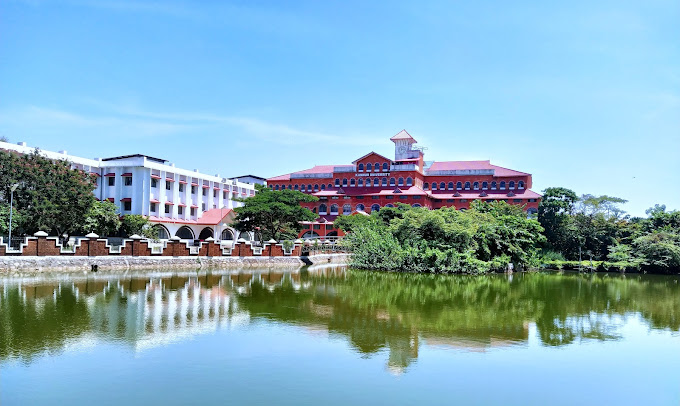


Muluppilagadu, India
Muluppilagadu is a town of 23,709 people in Kerala, India, founded in 1954.
Why visit Muluppilagadu
Townapedia lists 1 museum or landmark, 7 parks and trails, 9 places to eat, 10 places to stay and 2 attractions in and around town.
Highlights include Kannur University, Muzhappilangad Beach, Gundert Museum and Dharmadam Beach.
Weather in Muluppilagadu
Forecast from MET Norway (CC BY 4.0). Full forecast
About Muluppilagadu
Muzhappilangad (മുഴപ്പിലങ്ങാട്) is a coastal census town and grama panchayat in the Kannur district of the Indian state of Kerala. It is a suburb of Kannur city.
From the Wikipedia article Muzhappilangad (this version), under CC BY-SA 4.0.
Travel tips from other travellers: Muluppilagadu on Wikivoyage (CC BY-SA 4.0).
Things to do2
Kannur University
School · 1.8 km
State public university in Kannur, Kerala, India

Muzhappilangad Beach
Beach · 0.9 km
Beach in Kannur district, Keralam, India
Museums and landmarks1


Parks, trails and playgrounds7




Restaurants and cafes9

Shan Bakery
Bakery · 1.9 km
Kannur-Calicut-Valanchery Highway, Kannur
Mo-Sa 09:00-19:00



Where to stay10
Churches and places of worship22
Inderi Shiva Temple
Place of worship · Hindu · 2.3 km
Kannur-Calicut-Valanchery Highway, Kannur
ശ്രീ പൂത്രികോവിൽ ബാലഭദ്ര ക്ഷേത്രം
Place of worship · Hindu · 2.1 km
Kadambur-Kadachira road, kannur
Muzhapalangad Sree Bhaghavthy Temple
Place of worship · 0.9 km
4 ward New Street Muzhappilangad, Kannur
Shopping2
Schools, colleges and libraries37
DIET Lab School Palayad
School · 2.1 km
Chirakkuni-Station Road, Thalessery South ,Kannur
Kadambur English Medium School
School · 1.7 km
Edakkad-Kadambur Rd, Kannur South,Kannur
Angel Nursery And Upper Primary School
School
Kulam Bazar,Kadavu Road, Kannur South,Kannur
Kadambur Higher Secondary
School · 1.9 km
Edakkad-Kadambur Rd, Kannur South,Kannur
Kolad Junior Basic School Pinarayi
School · 2.8 km
Pinarayi, Thalassery North, Kannur
Maunathul Islam Lower Primary School
School · 2.1 km
Edakkad Beach Rd, Kannur South,Kannur
Healthcare8
Primary Health Centre Dharmadam
Hospital · 2.8 km
Dharmadam-Meloor-mamakunnu road
Map of Muluppilagadu
98 places. The map loads OpenStreetMap tiles when you open it.
Getting there and nearby towns
Kannur International Airport (CNN) is the nearest airport with scheduled flights listed in OpenStreetMap, 17 km away.
- Dharmadam 3 km southeast, about 3 min by car
- Tellicherry 7 km southeast, about 7 min by car
- Panoor 14 km east, about 14 min by car
- Pāppinisshēri 21 km northwest, about 21 min by car
- Irikkūr 24 km northeast, about 24 min by car
- Nādāpuram 26 km southeast, about 26 min by car
- Taliparamba 29 km north, about 29 min by car
- Nīlēshwar 62 km northwest, about 1 h by car
- Kanhangad 68 km northwest, about 1 h 15 min by car
- Kozhikode 71 km southeast, about 1 h 15 min by car
Drive times are estimates from straight-line distance, not routes.
Local news
Headlines from INDB.
Reviews, tips and questions
Loading what members have shared...
Sources and licences
- GeoNames (CC BY 4.0): population, coordinates, regions and time zone
- OpenStreetMap contributors (ODbL 1.0): places, airports, map data
- Wikidata (CC0 1.0): elevation, founding date, time zone, website, landmarks and historic places
- Wikimedia Commons (see each image): photos
- Wikipedia (CC BY-SA 4.0): overview and history text
Photo credits
- Hermann Gundert bungalow, Jameela P., CC BY-SA 4.0
- Muzhappilangad beach12, Ajeeshkumar4u, CC BY-SA 4.0
- Kannur Univerisity Thavakkara Campus, Rahul B Ashok, CC0
- Hoplobatrachus tigerinus 234692420, Vaishnav K V, CC BY 4.0
- Artocarpus altilis 3, Shagil Kannur, CC BY-SA 3.0
- 1 Nadan parippvada, kannur, kerala, Anjusha C, CC BY-SA 4.0
- A girl in the paddy field in Kerala, Shagil Kannur, CC BY-SA 4.0
- Sunset Muzhappilangad, Noushad naaz np, CC BY-SA 4.0
- Muzhappilangad Beach, Shagil Kannur, CC BY-SA 4.0
- Muzhappilangad Beach 3, Shagil Kannur, CC BY-SA 4.0
- Muzhappilangad beach (14), This photograph was taken by Rijin S and released under the license stated below. You are free to use it for any purpose as long as you credit the author ( Rijin S ), the Source (Wikimedia Commons)..., CC BY-SA 4.0
- A boat at Anjarakkandy river, Shagil Kannur, CC BY-SA 4.0
- Fishermen at work by Shagil Kannur, Shagil Kannur, CC BY-SA 4.0
- Lymantria ampla 336470924, Vaishnav K V, CC BY-SA 4.0
- Lymantria ampla 336470934, Vaishnav K V, CC BY-SA 4.0
- Lymantria ampla 336470944, Vaishnav K V, CC BY-SA 4.0
- Lymantria ampla 336470920, Vaishnav K V, CC BY-SA 4.0
- Moduza procris 333315247, Vaishnav K V, CC BY-SA 4.0
- Muzhappilangad beach (11), This photograph was taken by Rijin S and released under the license stated below. You are free to use it for any purpose as long as you credit the author ( Rijin S ), the Source (Wikimedia Commons)..., CC BY-SA 4.0
- Muzhappilangad beach (12), This photograph was taken by Rijin S and released under the license stated below. You are free to use it for any purpose as long as you credit the author ( Rijin S ), the Source (Wikimedia Commons)..., CC BY-SA 4.0
- Minervarya rufescens 326335380, Vaishnav K V, CC BY-SA 4.0
- Boats at Muzhappilangad Beach, Gnoeee, CC BY-SA 4.0
- Polypedates occidentalis 241064469, Vaishnav K V, CC BY 4.0
- Leptocoma zeylonica 234833215, Vaishnav K V, CC BY 4.0
- Plexippus paykulli 241727242, Vaishnav K V, CC BY-SA 4.0
- Hoplobatrachus tigerinus 234848825, Vaishnav K V, CC BY 4.0
- Hoplobatrachus tigerinus 234848842, Vaishnav K V, CC BY 4.0
- Flowers of Avicennia officinalis, Shagil Kannur, CC BY-SA 4.0
- Etakkot Railway Station, Gnoeee, CC BY-SA 4.0
- Polypedates occidentalis 250305386, Vaishnav K V, CC BY-SA 4.0
- Cnemaspis littoralis 249760535, Vaishnav K V, CC BY-SA 4.0
- Polypedates occidentalis 307771936, Vaishnav K V, CC BY-SA 4.0
- Hoplobatrachus tigerinus 250306936, Vaishnav K V, CC BY-SA 4.0
- Kinnara maculata 315681655, Vaishnav K V, CC BY-SA 4.0
- Vespa tropica 247481275, Vaishnav K V, CC BY-SA 4.0
- Oxyopes shweta 248002918, Vaishnav K V, CC BY-SA 4.0
- Polypedates occidentalis 248002809, Vaishnav K V, CC BY-SA 4.0
- Vespa tropica 247481285, Vaishnav K V, CC BY-SA 4.0
- Cnemaspis littoralis 249760756, Vaishnav K V, CC BY-SA 4.0
- Vespa tropica 247481265, Vaishnav K V, CC BY-SA 4.0


Page built November 3, 2026. Spotted a mistake? Tell us or suggest a place.