


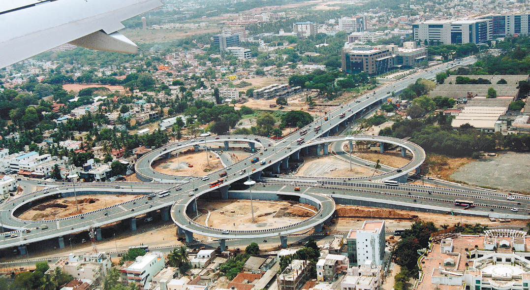


Why visit Manappakkam
Townapedia lists 7 museums and landmarks, 16 parks and trails, 38 places to eat, 9 places to stay and 3 attractions in and around town.
Highlights include Chennai Airport Flyover, Kathipara Junction, Chennai Trade Center and Babuji Memorial Ashram.
Weather in Manappakkam
Forecast from MET Norway (CC BY 4.0). Full forecast
About Manappakkam
Manapakkam is a neighborhood in Chennai in the Indian state of Tamil Nadu. A census town, Manapakkam is located along the Mount-Poonamallee Road in Chennai. It is now a home to many Core sector companies, like ABB, Hitachi Energy, DLF Cybercity Chennai and Larsen & Toubro.
From the Wikipedia article Manapakkam (this version), under CC BY-SA 4.0.
Things to do3

Museums and landmarks7

Parks, trails and playgrounds16

Ramasamy Nagar Children Park
Park · 2.0 km
Ramasamy Nagar Main Road, Chennai
sunrise-sunset


4 more on the map.
Restaurants and cafes38

Kilo Biriyani
Restaurant · Indian, Chinese, Arabic · 2.2 km
1/7 7th Cross Street, Venkateshwara Nagar, Ramapuram, Chennai, Tamil Nadu 600089, Chennai
Mo-Su 11:00-23:00
DA Brothers Restaurant
Restaurant · Indian · 1.7 km
2/239 Anna Main Road, Kolapakkam
Mo-Su 11:00-23:00

Siddhi Vinayaka Andhra Mess
Restaurant · 1.8 km
28/2 Mount Poonamallee Highway, Chennai
Sri Venkataramana Andhra Mess
Restaurant · 1.8 km
Mount Poonamallee Highway, Chennai
26 more on the map.
Where to stay9
Hotel Varsha
Motel and hotel · 1.7 km
45 Second main road, Sabari nagar, Porur, Chennai: 600 116
Les Crossants
Motel and hotel · 2.5 km
2 Bharathi Salai, Easwaran Nagar, Ramapuram, Chennai, Tamil Nadu 600089
Madharasi Womens Hostel
Motel and hotel · 2.5 km
2 Bharathi Salai,opposite to SRM college, Ramapuram. 600089
Suprabatham - Sweets and Veg. Restaurant
Motel and hotel · 2.8 km
No. 2, KPR Garden Thiruvalluvar Salai, Ramapuram
Churches and places of worship20
Karpaga Vinayagar Temple
Place of worship · 2.4 km
Madha Nagar Main Road, Chennai
Shopping12
Lokeshwari Maligai Store
Shopping center · 2.0 km
No: 2/3, Shanthi Nagar, Kanniappan Street, Shanthi Nagar Main Road, Park Dugar, Ramapuram, Chennai, Tamil Nadu 600089
Gas and EV charging8
Schools, colleges and libraries16
Hussainy Schools & Home for Children
School · Shia · 1.7 km
153 Mount - Poonamallee - Avadi Road, Chennai
St. Francis International School
School · 1.5 km
79 Anna Main Road, Kolapakkam, Gerugambakkam post, Chennai
R Square Academy for Tnpsc, Tnusrb SI, Tet, Police, Ssc, Rrb, Bank Exam Coaching Centre
School · 2.3 km
42-5 somasundaram Avenue, Mugalivakkam, Chennai, Tamil Nadu, porur
Lalaji Memorial Omega International School
School · 2.4 km
79 Pallavaram Road, Kolapakkam, Chennai
St. Christopher Nursery And Primary School
School · 1.1 km
Road in Mugalivakkam (to park and school), Mugalivakkam
Healthcare16
MIOT International
Hospital · 2.2 km
4/112, Mount Poonamalle High Rd, Sathya Nagar, Manapakkam, Chennai, Tamil Nadu 600089
Sri Nanthish Medicals
Clinic and pharmacy · 1.7 km
1 Sri Amman Nagar, Kolapakkam main road
Military Hospital
Hospital · 2.8 km
Mount Poonamalle High Rd, Seven Wells, St.Thomas Mount, Tamil Nadu 600016
Map of Manappakkam
145 places. The map loads OpenStreetMap tiles when you open it.
Getting there and nearby towns
Chennai International Airport (MAA) is the nearest airport with scheduled flights listed in OpenStreetMap, 2 km away.
- Mugalivakkam 1 km north, about 1 min by car
- Porur 3 km north, about 3 min by car
- Saint Thomas Mount 3 km east, about 3 min by car
- Pallāvaram 5 km southwest, about 5 min by car
- Madipakkam 6 km southeast, about 6 min by car
- Poonamalle 7 km northwest, about 7 min by car
- Nerkunram 7 km northeast, about 7 min by car
- Ambattur 10 km north, about 10 min by car
- Tambaram 11 km southwest, about 11 min by car
- Neelankarai 12 km southeast, about 12 min by car
Drive times are estimates from straight-line distance, not routes.
Local news
Headlines from INDB.
Reviews, tips and questions
Loading what members have shared...
Sources and licences
- GeoNames (CC BY 4.0): population, coordinates, regions and time zone
- OpenStreetMap contributors (ODbL 1.0): places, airports, map data
- Wikidata (CC0 1.0): elevation, founding date, time zone, website, landmarks and historic places
- Wikimedia Commons (see each image): photos
- Wikipedia (CC BY-SA 4.0): overview and history text
Photo credits
- Manapakkam signal, Ravichandar84, CC BY-SA 3.0
- Kathipara, Guru coolguy ( talk ), Public domain
- St. Thomas Garrison's church1, Ssriram mt, CC BY-SA 4.0
- St.Anne's Church OuterView, Mariya Ronald, CC0
- Aerial SE St Thomas Mount Chennai Jul25 R16 07931, Timothy A. Gonsalves, CC BY-SA 4.0
- Chennai Trade Centre, Tamilnadu Trade Promotion Organisation (Govt of Tamilnadu, India), CC BY-SA 4.0
- Side St Thomas Mount Church Chennai Aug22 A7C 02292, This Photo was taken by Timothy A. Gonsalves . Feel free to use my photos, but please mention me as the author. I would much appreciate if you send me an email [email protected] or write on my talk..., CC BY-SA 4.0
- RadissonBluChennai1, Rasnaboy, CC0
- Main Entrance St Thomas Mount Church Chennai Aug22 A7C 02249, This Photo was taken by Timothy A. Gonsalves . Feel free to use my photos, but please mention me as the author. I would much appreciate if you send me an email [email protected] or write on my talk..., CC BY-SA 4.0
- SotM 2025 Manila by Manoj Karingamadathil 02, Manojk, CC BY-SA 4.0
- SotM 2025 Manila by Manoj Karingamadathil 03, Manojk, CC BY-SA 4.0
- Varun Glitz, Joshuaink32, CC BY-SA 4.0
- Ola Case குட்டான், Paramatamil, CC BY-SA 4.0
- Town Bus Ticket of Pandiyan Roadways Corporation, Madurai (Late 70s or Early 80s), Paramatamil, CC BY-SA 4.0
- Antibiotic Refreshment Pot drink, Dharanyas, CC BY-SA 4.0
- Multigrain puttu with sprouts,nuts,veggies,fruits, Dharanyas, CC BY-SA 4.0
- L&T innovation campus under construction, VtTN, CC BY-SA 4.0
- California Burrito, VideshiBhaktNRI, CC0
- Multigrain Vermicelli with sprouts,nuts,vegies and fruits, Dharanyas, CC BY-SA 4.0
- Multigrain Dishes with Energizing drink, Dharanyas, CC BY-SA 4.0
- Dessert Works Bangalore, VideshiBhaktNRI, CC0
- DLF Cybercity Chennai, Hexatron93, CC BY-SA 4.0
- Seashore14, Surendranjr, CC BY-SA 4.0
- CJB 2, pravin.premkumar, CC BY 2.0
- Kanitamil conference wiki stall, சத்திரத்தான், CC BY-SA 4.0
- 25 Garuda seva, சத்திரத்தான், CC BY-SA 4.0
- Neechlkaran with visitors in Kanitamil conference, சத்திரத்தான், CC BY-SA 4.0
- Aazhi Senthilnathab, சத்திரத்தான், CC BY-SA 4.0
- Girija ragshavan, சத்திரத்தான், CC BY-SA 4.0
- It minister of Tamil Nadu PTR Palanivel Rajan, சத்திரத்தான், CC BY-SA 4.0
- ATR72 JetKonnect, arunpnair, CC BY-SA 2.0
- Chennai International Airport - 01, Oleg Yunakov, CC BY-SA 4.0
- Sun set 2, User:arundpt, CC BY-SA 3.0
- AirCosta 2, arunpnair, CC BY-SA 2.0
- Nagathamman koil, Iqsaja, CC BY-SA 3.0
- Chennai-International-Book̠Fair-Chennai-India, N. Vivekananthamoorthy, CC BY-SA 4.0
- Left Sri Lankan A330 4R-ALT Chennai Jul25 R16 07938, Timothy A. Gonsalves, CC BY-SA 4.0
- Right Sri Lankan A330 4R-ALT Chennai Jul25 R16 07944, Timothy A. Gonsalves, CC BY-SA 4.0
- Nagathamman Temple, Subashcm3087, CC BY-SA 4.0
- Periapalayathamman Meenambakkam, Subashcm3087, CC BY-SA 4.0


Page built November 3, 2026. Spotted a mistake? Tell us or suggest a place.