
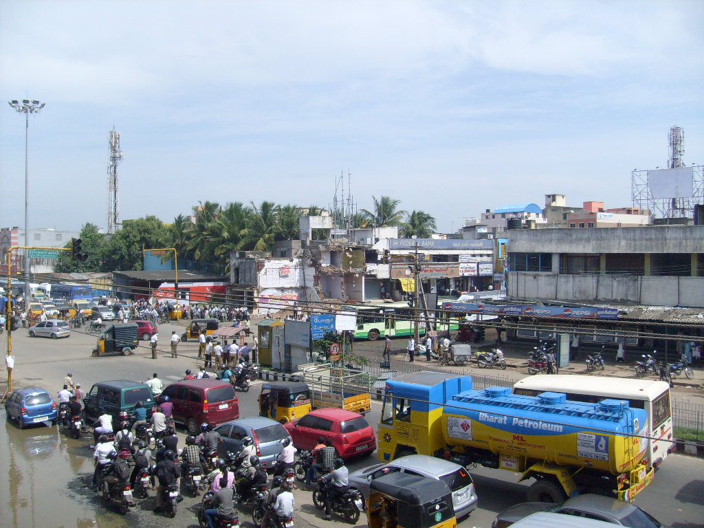


Why visit Porur
Townapedia lists 14 parks and trails, 25 places to eat, 7 places to stay and 1 attraction in and around town.
Highlights include Maduravoyal Junction, Dr. M.S. Swaminathan Wetland Eco Park and Ramasamy Nagar Children Park.
Weather in Porur
Forecast from MET Norway (CC BY 4.0). Full forecast
About Porur
Porur (Tamil: [poːɾuːɾ]) is a neighbourhood of the city of Chennai, India. It forms part of the Maduravoyal taluk of Chennai district. Situated about 17 kilometres (11 miles) by road from Chennai in the western part of the city, Porur is largely a residential neighbourhood with a significant portion devoted to commercial and industrial activities. Porur's ideal geographic position at the junction of the Mount-Poonamallee and Kundrathur roads at the western gates to Chennai city remains a major driver of economic growth.
From the Wikipedia article Porur (this version), under CC BY-SA 4.0.
Things to do1

Parks, trails and playgrounds14

Dr. M.S. Swaminathan Wetland Eco Park
Park · 1.4 km
Chettiyar Agaram Road, Chennai
Mo-Su 5:00-21:00
Ramasamy Nagar Children Park
Park · 1.1 km
Ramasamy Nagar Main Road, Chennai
sunrise-sunset

2 more on the map.
Restaurants and cafes25

Kilo Biriyani
Restaurant · Indian, Chinese, Arabic · 1.9 km
1/7 7th Cross Street, Venkateshwara Nagar, Ramapuram, Chennai, Tamil Nadu 600089, Chennai
Mo-Su 11:00-23:00


Siddhi Vinayaka Andhra Mess
Restaurant · 2.2 km
28/2 Mount Poonamallee Highway, Chennai
Sri Venkataramana Andhra Mess
Restaurant · 2.2 km
Mount Poonamallee Highway, Chennai
13 more on the map.
Where to stay7

Hotel Varsha
Motel and hotel · 1.7 km
Home food
45 Second main road, Sabari nagar, Porur, Chennai: 600 116
Mo-Su 10:00-22:00
Les Crossants
Motel and hotel · 2.1 km
Bakery and fast food
2 Bharathi Salai, Easwaran Nagar, Ramapuram, Chennai, Tamil Nadu 600089
Mo-Su 10:00-22:00
Madharasi Womens Hostel
Motel and hotel · 2.1 km
Girls Hostel
2 Bharathi Salai,opposite to SRM college, Ramapuram. 600089
History
The Ramanatheswarar Temple in Porur has an inscription of the Chola king Kulothunga I who reigned from 1070 CE to 1122 CE. Porur might have served as the administrative centre of the eponymous Perūr Nādū of the Chola province of Puliyur Kottam. The juridisction of Perur Nadu extended over a considerable area and included the surrounding neighbourhoods of Manapakkam and Kolapakkam as evidenced by inscriptions at the Agasteeswarar Temple in Kolapakkam.
The earliest modern references to Porur come from British maps and books of the late 18th century. In the early 19th century, the Kodambakkam-Kunrathur road and the St. Thomas Mount-Poonamallee Road were major trade and communication routes leading into Chennai city. However still, Porur was predominantly rural and sparsely populated till the 1960s, when the W. S. Insulators and the Moonlight factory were established with land and support from the Government of Tamil Nadu. The population grew from 1,938 in 1961 to 3,539 in 1971 and accelerated even further in the following decades achieving growth rates of 144 percent and 126 percent during 1971–1981 and 1981–1991 respectively.
From the History section of Porur on Wikipedia, under CC BY-SA 4.0.
Churches and places of worship9
Karpaga Vinayagar Temple
Place of worship · 2.2 km
Madha Nagar Main Road, Chennai
Shopping7
Lokeshwari Maligai Store
Shopping center · 2.3 km
No: 2/3, Shanthi Nagar, Kanniappan Street, Shanthi Nagar Main Road, Park Dugar, Ramapuram, Chennai, Tamil Nadu 600089
Gas and EV charging4
Schools, colleges and libraries13
Hussainy Schools & Home for Children
School · Shia · 1.8 km
153 Mount - Poonamallee - Avadi Road, Chennai
R Square Academy for Tnpsc, Tnusrb SI, Tet, Police, Ssc, Rrb, Bank Exam Coaching Centre
School · 0.8 km
42-5 somasundaram Avenue, Mugalivakkam, Chennai, Tamil Nadu, porur
Grace Matriculation Higher Secondary School
School · 0.7 km
4/17 , Kambar Street, Arunachalam Nagar, Karambakkam, Porur Kanchipuram, kanchipuram
Rajiv School of Excellence Matriculation & Higher Secondary
School · 0.6 km
5/516-B Sakthi sairam st, Ganapathy Nagar
St. Christopher Nursery And Primary School
School · 2.0 km
Road in Mugalivakkam (to park and school), Mugalivakkam
Healthcare20
Sri Ramachandra Institute of Higher Education and Research
Hospital · 1.8 km
Map of Porur
100 places. The map loads OpenStreetMap tiles when you open it.
Getting there and nearby towns
Chennai International Airport (MAA) is the nearest airport with scheduled flights listed in OpenStreetMap, 5 km away.
- Mugalivakkam 2 km southeast, about 2 min by car
- Poonamalle 5 km west, about 5 min by car
- Saint Thomas Mount 5 km southeast, about 5 min by car
- Ambattur 7 km north, about 7 min by car
- Pallāvaram 8 km south, about 8 min by car
- Avadi 10 km northwest, about 10 min by car
- Tambaram 13 km south, about 13 min by car
- Chennai 14 km northeast, about 14 min by car
- Vandalūr 18 km southwest, about 18 min by car
- Tiruvottiyūr 21 km northeast, about 21 min by car
Drive times are estimates from straight-line distance, not routes.
Local news
Headlines from INDB.
Reviews, tips and questions
Loading what members have shared...
Sources and licences
- GeoNames (CC BY 4.0): population, coordinates, regions and time zone
- OpenStreetMap contributors (ODbL 1.0): places, airports, map data
- Wikidata (CC0 1.0): elevation, founding date, time zone, website, landmarks and historic places
- Wikimedia Commons (see each image): photos
- Wikipedia (CC BY-SA 4.0): overview and history text
Photo credits
- Porur Junction, Ravichandar84, CC BY-SA 3.0
- St.Anne's Church OuterView, Mariya Ronald, CC0
- Sri Ramachandra Institute, Sriher, CC BY-SA 4.0
- Main Entrance St Thomas Mount Church Chennai Aug22 A7C 02249, This Photo was taken by Timothy A. Gonsalves . Feel free to use my photos, but please mention me as the author. I would much appreciate if you send me an email [email protected] or write on my talk..., CC BY-SA 4.0
Page built November 3, 2026. Spotted a mistake? Tell us or suggest a place.