


Why visit Mugalivakkam
Townapedia lists 2 museums and landmarks, 16 parks and trails, 31 places to eat, 8 places to stay and 3 attractions in and around town.
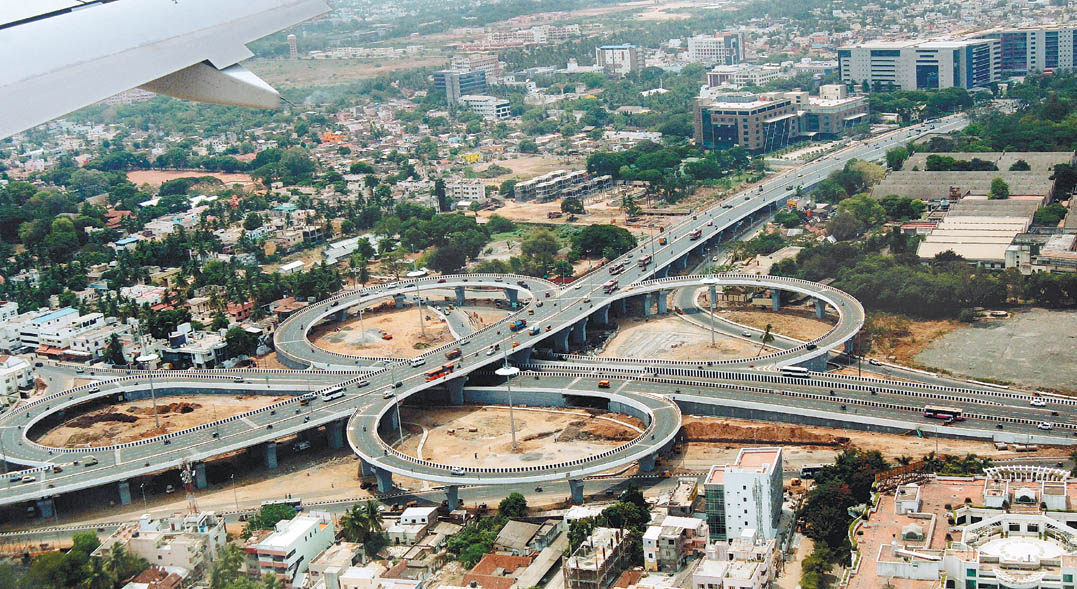
Highlights include Chennai Airport Flyover, Kathipara Junction, Babuji Memorial Ashram and Ramasamy Nagar Children Park.
Weather in Mugalivakkam
Forecast from MET Norway (CC BY 4.0). Full forecast
About Mugalivakkam
Mugalivakkam is a neighbourhood of Chennai. It is located in Sriperumbudur taluk of Kanchipuram district, in Tamil Nadu. It is situated 16 km south-west of Chennai on the Mount-Poonamallee Road. It is bounded by Porur on the north, Meenambakkam and Manapakkam on the south and south east, Madhanandhapuram, Kovur, Chennai and Gerugambakkam on the south west and Ramapuram on the north east.
From the Wikipedia article Mugalivakkam (this version), under CC BY-SA 4.0.
Things to do3

Museums and landmarks2

Parks, trails and playgrounds16

Ramasamy Nagar Children Park
Park · 0.9 km
Ramasamy Nagar Main Road, Chennai
sunrise-sunset

4 more on the map.
Restaurants and cafes31

Kilo Biriyani
Restaurant · Indian, Chinese, Arabic · 1.4 km
1/7 7th Cross Street, Venkateshwara Nagar, Ramapuram, Chennai, Tamil Nadu 600089, Chennai
Mo-Su 11:00-23:00
DA Brothers Restaurant
Restaurant · Indian · 1.7 km
2/239 Anna Main Road, Kolapakkam
Mo-Su 11:00-23:00

Siddhi Vinayaka Andhra Mess
Restaurant · 1.3 km
28/2 Mount Poonamallee Highway, Chennai
Sri Venkataramana Andhra Mess
Restaurant · 1.3 km
Mount Poonamallee Highway, Chennai
19 more on the map.
Where to stay8
Hotel Varsha
Motel and hotel · 0.7 km
45 Second main road, Sabari nagar, Porur, Chennai: 600 116
Les Crossants
Motel and hotel · 1.8 km
2 Bharathi Salai, Easwaran Nagar, Ramapuram, Chennai, Tamil Nadu 600089
Madharasi Womens Hostel
Motel and hotel · 1.8 km
2 Bharathi Salai,opposite to SRM college, Ramapuram. 600089
Suprabatham - Sweets and Veg. Restaurant
Motel and hotel · 2.3 km
No. 2, KPR Garden Thiruvalluvar Salai, Ramapuram
Churches and places of worship17
Karpaga Vinayagar Temple
Place of worship · 1.9 km
Madha Nagar Main Road, Chennai
Shopping12
Lokeshwari Maligai Store
Shopping center · 1.5 km
No: 2/3, Shanthi Nagar, Kanniappan Street, Shanthi Nagar Main Road, Park Dugar, Ramapuram, Chennai, Tamil Nadu 600089
Gas and EV charging5
Schools, colleges and libraries11
Hussainy Schools & Home for Children
School · Shia · 0.9 km
153 Mount - Poonamallee - Avadi Road, Chennai
St. Francis International School
School · 1.5 km
79 Anna Main Road, Kolapakkam, Gerugambakkam post, Chennai
R Square Academy for Tnpsc, Tnusrb SI, Tet, Police, Ssc, Rrb, Bank Exam Coaching Centre
School · 1.1 km
42-5 somasundaram Avenue, Mugalivakkam, Chennai, Tamil Nadu, porur
Grace Matriculation Higher Secondary School
School · 2.5 km
4/17 , Kambar Street, Arunachalam Nagar, Karambakkam, Porur Kanchipuram, kanchipuram
Rajiv School of Excellence Matriculation & Higher Secondary
School · 2.0 km
5/516-B Sakthi sairam st, Ganapathy Nagar
St. Christopher Nursery And Primary School
School
Road in Mugalivakkam (to park and school), Mugalivakkam
Healthcare22
MIOT International
Hospital · 2.2 km
4/112, Mount Poonamalle High Rd, Sathya Nagar, Manapakkam, Chennai, Tamil Nadu 600089
Sri Nanthish Medicals
Clinic and pharmacy · 1.7 km
1 Sri Amman Nagar, Kolapakkam main road
Map of Mugalivakkam
127 places. The map loads OpenStreetMap tiles when you open it.
Getting there and nearby towns
Chennai International Airport (MAA) is the nearest airport with scheduled flights listed in OpenStreetMap, 3 km away.
- Saint Thomas Mount 4 km southeast, about 4 min by car
- Pallāvaram 6 km south, about 6 min by car
- Poonamalle 6 km northwest, about 6 min by car
- Ambattur 9 km north, about 9 min by car
- Tambaram 11 km south, about 11 min by car
- Avadi 12 km northwest, about 12 min by car
- Chennai 14 km northeast, about 14 min by car
- Vandalūr 17 km southwest, about 17 min by car
- Tiruvottiyūr 21 km northeast, about 21 min by car
- Mahabalipuram 45 km south, about 45 min by car
Drive times are estimates from straight-line distance, not routes.
Local news
Headlines from INDB.
Reviews, tips and questions
Loading what members have shared...
Sources and licences
- GeoNames (CC BY 4.0): population, coordinates, regions and time zone
- OpenStreetMap contributors (ODbL 1.0): places, airports, map data
- Wikidata (CC0 1.0): elevation, founding date, time zone, website, landmarks and historic places
- Wikimedia Commons (see each image): photos
- Wikipedia (CC BY-SA 4.0): overview and history text
Photo credits
- Kathipara, Guru coolguy ( talk ), Public domain
- St. Thomas Garrison's church1, Ssriram mt, CC BY-SA 4.0
- St.Anne's Church OuterView, Mariya Ronald, CC0
- Main Entrance St Thomas Mount Church Chennai Aug22 A7C 02249, This Photo was taken by Timothy A. Gonsalves . Feel free to use my photos, but please mention me as the author. I would much appreciate if you send me an email [email protected] or write on my talk..., CC BY-SA 4.0
Page built November 3, 2026. Spotted a mistake? Tell us or suggest a place.