


Mibu, Japan
壬生町
Mibu is a town of 39,474 people in Tochigi, Japan, founded in April 1, 1889.
Why visit Mibu
Townapedia lists 31 museums and landmarks, 72 parks and trails, 132 places to eat, 4 places to stay and 11 attractions in and around town.
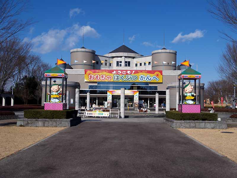
Highlights include Jichi Medical University, Dokkyo Medical University, Omochanomachi Bandai Museum and Mibumachi Toy Museum.
Weather in Mibu
Forecast from MET Norway (CC BY 4.0). Full forecast
About Mibu
Mibu (壬生町, Mibu-machi) is a town located in Tochigi Prefecture, Japan. As of 1 August 2020, the town had an estimated population of 39,158 in 16,149 households, and a population density of 640 persons per km2. The total area of the town is 61.06 square kilometres (23.58 sq mi).
From the Wikipedia article Mibu, Tochigi (this version), under CC BY-SA 4.0.
Things to do11

Jichi Medical University
School · 5.7 km
Higher education institution in Tochigi Prefecture, Japan

Dokkyo Medical University
School · 6.6 km
Higher education institution in Tochigi Prefecture, Japan



Museums and landmarks31


Kamikōnushi-Mobara Kanga ruins
Monument and historic site · 9.2 km
Ancient ruins in Utsunomiya, Kantō, Japan

The Site of Shimotsuke Provincial Government
Monument and historic site · 4.3 km
Historic site in Tochigi, Japan



19 more on the map.
Parks, trails and playgrounds72


60 more on the map.
Restaurants and cafes132



手造りうどん けやき
Restaurant · Japanese · 6.4 km
6
Tu-Su 11:00-14:00, 17:00-22:00
蕎麦 吉本店
Restaurant · Japanese · 6.1 km
2
We-Mo 11:00-14:00, 17:00-21:00
120 more on the map.
History
The remains of many burial mounds from the Kofun period can be found in Mibu. During the Edo period, the area was controlled by Mibu Domain under the Tokugawa shogunate. The jōkamachi which grew up around Mibu Castle was Mibu-shuku a post station on a branch the Nikkō Kaidō connecting Edo with the shrines at Nikkō. After the Meiji restoration, Mibu town and the villages of Inaba and Minami-Inukai were created within Shimotsuga District on April 1, 1889, with the creation of the modern municipalities system. Inaba merged with Mibu on November 3, 1954, followed by Minami-Inukai on July 28, 1955.
From the History section of Mibu, Tochigi on Wikipedia, under CC BY-SA 4.0.
Where to stay4
Churches and places of worship63
Shopping44
Gas and EV charging9
Schools, colleges and libraries38
Healthcare56
Map of Mibu
250 places. The map loads OpenStreetMap tiles when you open it.
Getting there and nearby towns
Ibaraki Airport (IBR) is the nearest airport with scheduled flights listed in OpenStreetMap, 61 km away.
- Tochigi 7 km southwest, about 7 min by car
- Oyama 13 km south, about 13 min by car
- Yūki 15 km southeast, about 15 min by car
- Chikusei 20 km southeast, about 20 min by car
- Shimodate 21 km southeast, about 21 min by car
- Sano 22 km southwest, about 22 min by car
- Koga 27 km south, about 27 min by car
- Iwase 28 km east, about 28 min by car
- Yachiyo 27 km south, about 27 min by car
- Tatebayashi 30 km southwest, about 30 min by car
Drive times are estimates from straight-line distance, not routes.
Local news
Headlines from INDB.
Reviews, tips and questions
Loading what members have shared...
Sources and licences
- GeoNames (CC BY 4.0): population, coordinates, regions and time zone
- OpenStreetMap contributors (ODbL 1.0): places, airports, map data
- Wikidata (CC0 1.0): elevation, founding date, time zone, website, landmarks and historic places
- Wikimedia Commons (see each image): photos
- Wikipedia (CC BY-SA 4.0): overview and history text
Photo credits
- Mibu town office, Altomarina, CC BY-SA 3.0
- Mibu Junior High School, Miyuki Meinaka, CC BY-SA 4.0
- Mibu Station - Nov 3 2020 - various 15 30 16 913000, Nesnad, CC BY 4.0
- Tobu-railway-TN33-Mibu-station-platform-20210803-083531, LERK, CC BY-SA 4.0
- Mibu Station - Nov 3 2020 - various 15 30 04 843000, Nesnad, CC BY 4.0
- Tobu-railway-TN33-Mibu-station-building-20210803-084007, LERK, CC BY-SA 4.0
- Mibu Station - Nov 3 2020 - various, Nesnad, CC BY 4.0
- Mibu Station - Nov 3 2020 - various 15 29 11 915000, Nesnad, CC BY 4.0
- Mibu Station - Nov 3 2020 - various 15 28 39 059000, Nesnad, CC BY 4.0
- Mibu Station - Nov 3 2020 - various 15 29 45 277000, Nesnad, CC BY 4.0
- Mibu Station - Nov 3 2020 - various 15 28 55 648000, Nesnad, CC BY 4.0
- Mibu JHS site, Miyuki Meinaka, CC BY-SA 4.0
- Tomb of Mibu clan, Joraku-ji temple, Miyuki Meinaka, CC BY-SA 4.0
- Mibu Temple Hondo, Miyuki Meinaka, CC BY-SA 4.0
- Ginkgo, Mibu Temple, Miyuki Meinaka, CC BY-SA 4.0
- Ubuyu, Mibu Temple, Miyuki Meinaka, CC BY-SA 4.0
- Mibu Town Office, Oct. 2022 1, Miyuki Meinaka, CC BY-SA 4.0
- Mibu Town Office, Oct. 2022 2, Miyuki Meinaka, CC BY-SA 4.0
- Historical Government Buildings Site of Kamikonushi & Mobara 02, Miyuki Meinaka, CC BY-SA 4.0
- Dokkyo Medical University2009, Miyuki Meinaka, Public domain
- Shimotsuke-kokubunji hondou, Saigen Jiro, CC0
- Mibu-toysmuseum, Comyu, CC BY-SA 3.0
- Oomiwa-jinja (tochigishi) torii, Saigen Jiro, Public domain
- Tsuga Junior Highschool, Asasa198 This photo was taken with Fujifilm FinePix AX300, CC BY-SA 4.0
- Ishibashi Highschool(Japan,Tochigi) East Ent, ほぶ, Public domain
- 獨協医科大学病院, 機竜, CC BY-SA 3.0
- Jichi Medical University2009, Miyuki Meinaka, Public domain
- Koganei Ichirizuka, Tochigi, ニンジンシチュー, CC0
- Jigen-ji temple, Shimotsuke, Miyuki Meinaka, CC BY-SA 4.0
- Kassemba elementary school, Tochigi, Miyuki Meinaka, CC BY-SA 4.0
- Jichi Med. Univ. Education & Research Center, Miyuki Meinaka, CC BY-SA 4.0
- Shimotsuke Kokucho Ruins maedono, Saigen Jiro, CC0
- Dokkyo Medical University, Building of Basic Medicine, Miyuki Meinaka, CC BY-SA 4.0
- Mibu Bandai Museum Appearance 1, 京浜にけ, CC BY-SA 3.0
- Kaminokawa High School, M yanagisawa, CC BY 3.0
- Tochigi Municipal Toyo Junior High School, 国鉄115系湘南色, CC BY 3.0
- Saizeriya Yoshikawa factory, Ebiebi2, CC BY-SA 3.0
- Tochigi city Tochigi east junior high school, うらにわ, CC BY-SA 4.0
- Tochigi city Kou-Kita Elementary School, 国鉄115系湘南色, Public domain
- Jichi Med. Univ. Hospital 2, Miyuki Meinaka, CC BY-SA 4.0
- 下野国分寺跡 伽藍, Saigen Jiro, Public domain


Page built November 5, 2026. Spotted a mistake? Tell us or suggest a place.