


Littleton Common, Massachusetts
Littleton Common is a community of 3,289 people in Middlesex County, Massachusetts.
Why visit Littleton Common
Townapedia lists 14 museums and landmarks, 45 parks and trails, 20 places to eat, 1 place to stay and 14 attractions in and around town.
Highlights include O'Neil Cinemas, Nashoba Valley Ski Area, Boxborough Old Town Center and Forge Village Historic District.
July is the warmest month, with average highs of 87°F; January lows average 15°F.
Weather in Littleton Common
Forecast from the National Weather Service. Full forecast
About Littleton Common
Littleton Common is a census-designated place (CDP) in the town of Littleton in Middlesex County, Massachusetts, United States. The population was 3,065 at the 2020 census, up from 2,789 in 2010.
From the Wikipedia article Littleton Common, Massachusetts (this version), under CC BY-SA 4.0.
Things to do14

O'Neil Cinemas
Cinema and theater · 1.2 mi
1208 Constitution Avenue, Littleton
Mo-Su 10:30-22:30



2 more on the map.
Museums and landmarks14

Boxborough Old Town Center
Monument and historic site · National Register of Historic Places · 3.8 mi
Boxborough, Massachusetts, listed on the NRHP in Massachusetts

Forge Village Historic District
Monument and historic site · National Register of Historic Places · 3.2 mi
Historic district in Massachusetts, United States
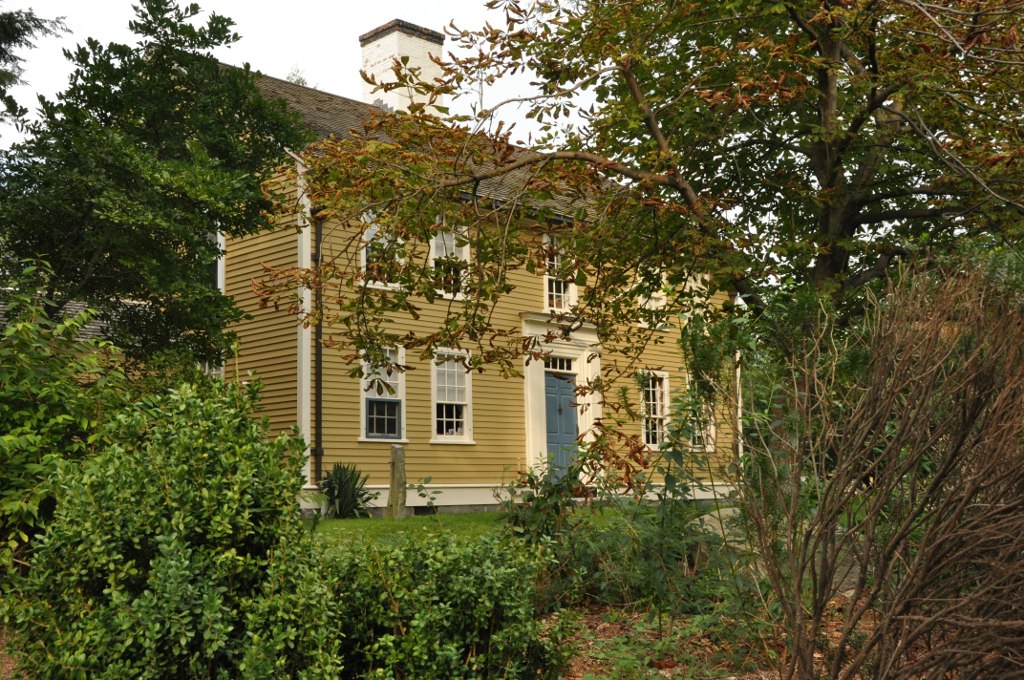
Henry Fletcher House
Monument and historic site · National Register of Historic Places · 2.5 mi
Building in Massachusetts, United States

Houghton Memorial Building
Monument and historic site · National Register of Historic Places · 0.7 mi
Building in Massachusetts, United States

John Proctor House
Monument and historic site · National Register of Historic Places · 2.5 mi
Listed on the National Register of Historic Places in Middlesex County, Massachusetts

North Acton Cemetery
Monument and historic site · National Register of Historic Places · 3.7 mi
Cemetery in North Acton, Middlesex County, Massachusetts, United States

Old Burying Ground
Monument and historic site · National Register of Historic Places · 0.8 mi
Cemetery in Littleton, Massachusetts

Parker Village Historic District
Monument and historic site · National Register of Historic Places · 3.0 mi
Historic district in Massachusetts, United States

Reed-Wood Place
Monument and historic site · National Register of Historic Places · 0.8 mi
Building in Massachusetts, United States

Russian Cemetery
Monument and historic site · National Register of Historic Places · 3.0 mi
Historic cemetery in Westford, Massachusetts, United States

Westford Center Historic District
Monument and historic site · National Register of Historic Places · 3.6 mi
Historic district in Massachusetts, United States


Westford Town Farm
Monument and historic site · National Register of Historic Places · 3.6 mi
Building in Massachusetts, United States
2 more on the map.
Parks, trails and playgrounds45





33 more on the map.
Restaurants and cafes20

Anthony's Coal Fired Pizza
Restaurant · Pizza, Wings · 1.2 mi
201 Constitution Avenue, Littleton
Mo-Th,Su 11:30-22:00; Fr-Sa 11:30-23:00
Great Road Kitchen
Restaurant · Regional · 1.2 mi
613 Constitution Avenue, Littleton
Tu-Th 11:30-21:00; Su 10:30-21:00; Mo 17:00-21:00; Fr-Sa 11:30-22:00
Il Forno
Restaurant · International, Italian · 0.9 mi
529 King Street, Littleton
Mo off; Tu-Th 11:00-20:00; Fr 11:00-21:00; Sa 16:00-21:00; Su 11:00-20:00
Masala Bay Indian Kitchen
Restaurant · Indian · 1.2 mi
501 Constitution Avenue, Littleton
11:30-15:00,17:00-22:00

Starbucks
Cafe · Coffee Shop · 1.2 mi
495 Constitution Avenue, Littleton
Mo-Th 04:30-21:00; Fr 04:30-21:30; Sa 05:30-21:30; Su 05:30-21:00
Taka
Restaurant · Asian, Chinese, Japanese · 1.2 mi
602 Constitution Avenue, Littleton
Mo-Th 11:30-22:00; Fr-Sa 11:30-23:00; Su 12:00-22:00

Tavern in the Square
Diner · American · 1.2 mi
810 Constitution Avenue, Littleton
Mo-We 11:30-24:00; Th-Sa 11:30-01:00; Su 10:00-24:00


8 more on the map.
Where to stay1
Churches and places of worship6
Shopping11
Gas and EV charging6
Schools, colleges and libraries26
Healthcare1
Map of Littleton Common
144 places. The map loads OpenStreetMap tiles when you open it.
Climate by month
Monthly table
| Month | High | Low | Rain |
|---|---|---|---|
| Jan | 37°F | 15°F | 3.6 in |
| Feb | 41°F | 16°F | 3.3 in |
| Mar | 48°F | 24°F | 4.6 in |
| Apr | 62°F | 34°F | 4.4 in |
| May | 73°F | 45°F | 3.7 in |
| Jun | 81°F | 55°F | 4.2 in |
| Jul | 87°F | 60°F | 4.0 in |
| Aug | 85°F | 58°F | 4.4 in |
| Sep | 78°F | 49°F | 3.9 in |
| Oct | 66°F | 38°F | 5.1 in |
| Nov | 54°F | 29°F | 3.8 in |
| Dec | 43°F | 21°F | 4.8 in |
U.S. Climate Normals 1991-2020 for Maynard 2 (7 mi away), NOAA NCEI.
People and cost of living
American Community Survey 5-year estimates, 2020-2024, U.S. Census Bureau. Estimates have margins of error, larger for small towns.
Disaster history
Middlesex County has had 26 federal disaster declarations since 2000, most often for severe storms.
- 2023-09-15: Hurricane Lee (Hurricane)
- 2020-03-27: Covid-19 Pandemic (Biological)
- 2020-03-13: Covid-19 (Biological)
- 2018-07-19: Severe Winter Storm And Snowstorm (Snowstorm)
- 2015-04-13: Severe Winter Storm, Snowstorm, And Flooding (Severe Storm)
- 2013-04-19: Severe Winter Storm, Snowstorm, And Flooding (Severe Storm)
OpenFEMA disaster declarations summaries.
Getting there and nearby towns
Minute Man Airfield (MMN) is the nearest airport with scheduled flights listed in OpenStreetMap, 6 miles away.
- Ayer 6 mi west, about 10 min by car
- Devens 7 mi west, about 12 min by car
- Groton 7 mi northwest, about 11 min by car
- Maynard 8 mi south, about 12 min by car
- East Pepperell 10 mi northwest, about 16 min by car
- Lowell 11 mi northeast, about 17 min by car
- Hudson 11 mi southwest, about 18 min by car
- Hanscom AFB 11 mi southeast, about 18 min by car
- Marlborough 13 mi south, about 21 min by car
- Lexington 14 mi southeast, about 22 min by car
Drive times are estimates from straight-line distance, not routes.
Local news
Headlines from INDB, the NEMICO news database.
Reviews, tips and questions
Loading what members have shared...
Sources and licences
- NCES EDGE (Public domain): public schools
- NOAA NCEI U.S. Climate Normals 1991-2020 (Public domain): climate by month
- OpenFEMA (Public domain): disaster declarations
- OpenStreetMap contributors (ODbL 1.0): places, airports, map data
- U.S. Census Bureau (Public domain): population, income, housing, education, commute
- Wikidata (CC0 1.0): elevation, founding date, time zone, website, landmarks and historic places
- Wikimedia Commons (see each image): photos
- Wikipedia (CC BY-SA 4.0): overview and history text
Photo credits
- Reed-Wood Place, Littleton Common MA, John Phelan, CC BY-SA 4.0
- Houghton Memorial Building, Littleton MA, John Phelan, CC BY 3.0
- Fletcher House c1843, Westford Center, MA, John Phelan, CC BY 3.0
- Old Burying Ground, Littleton MA, John Phelan, CC BY 3.0
- Parkerville Schoolhouse 1880, Parker Village, MA, John Phelan, CC BY 3.0
- North Cemetery, Boxborough MA, John Phelan, CC BY 3.0
- WestfordMA WestlawnCemetery, User:Magicpiano, CC BY-SA 4.0
- Abbott Worsted Company 1910, Forge Village, MA, John Phelan, CC BY 3.0
- WestfordMA HenryFletcherHouse, User:Magicpiano, CC BY-SA 4.0
- Russian Cemetery, Westford MA, John Phelan, CC BY 3.0
- ActonMA NorthActonCemetery, Magicpiano, CC BY-SA 4.0
- Westford Town Farm, MA, John Phelan, CC BY 3.0
- WestfordMA JohnProctorHouse, User:Magicpiano, CC BY-SA 4.0
- Reed-Wood Place, Littleton MA, John Phelan, CC BY 3.0
- Nashoba Valley Ski Area, Westford MA, John Phelan, CC BY-SA 3.0
- Postcard of Panevezys, Unknown author Unknown author, Public domain
- Atari Video Music output, Victor Grigas, CC BY-SA 4.0
- Red Coleman cooler, Victor Grigas, CC BY-SA 4.0
- Paddy Bauler circa 1926, Republican Booster Club of Chicago, Public domain
- Haymarket square 1880s, Strohmeyer & Wyman, Public domain
- Dvi eia- 861, Victor Grigas, CC BY-SA 4.0
- Shorty in a turn - Flickr - Jelly Dude, Jelly Dude, CC BY 2.0
- Aubuchon Hardware (53001019149), Todd Van Hoosear, CC BY-SA 2.0
- Littleton, Massachusetts (5240025828), Doug Kerr from Albany, NY, United States, CC BY-SA 2.0
- Littleton, Massachusetts (5239429251), Doug Kerr from Albany, NY, United States, CC BY-SA 2.0
- Littleton, Massachusetts (5240025284), Doug Kerr from Albany, NY, United States, CC BY-SA 2.0
- Littleton, Massachusetts (5240024604), Doug Kerr from Albany, NY, United States, CC BY-SA 2.0
- Littleton, Massachusetts (5239428259), Doug Kerr from Albany, NY, United States, CC BY-SA 2.0
- Littleton, Massachusetts (5240028740), Doug Kerr from Albany, NY, United States, CC BY-SA 2.0
- Littleton, Massachusetts (5240028000), Doug Kerr from Albany, NY, United States, CC BY-SA 2.0
- Littleton, Massachusetts (5239428861), Doug Kerr from Albany, NY, United States, CC BY-SA 2.0
- Littleton, Massachusetts (5240029398), Doug Kerr from Albany, NY, United States, CC BY-SA 2.0
- Boston Metrowest Bible Church, Littleton MA, John Phelan, CC BY-SA 4.0
- Littleton Massachusetts Haze July 26 2021, Victor Grigas, CC BY-SA 4.0
- Trail Marker In Woods, Littleton, MA1970 (6329948532), inkknife_2000 (7.5 million views +), CC BY-SA 2.0
- Lake In Woods, Littleton, MA 1970 (6323211223), inkknife_2000 (7.5 million views +), CC BY-SA 2.0
- Old Barn, Acton, MA 1972 (6378912597), inkknife_2000 (7.5 million views +), CC BY-SA 2.0
- Decomposed Car In Woods, Littleton, MA 1970 (6323212083), inkknife_2000 (7.5 million views +), CC BY-SA 2.0
- Littleton station construction November 2012, Pi.1415926535, CC BY-SA 3.0
- Littleton station with train November 22 2012, Pi.1415926535, CC BY-SA 3.0


Page built October 30, 2026. Spotted a mistake? Tell us or suggest a place.