


Why visit Rahway
Townapedia lists 7 museums and landmarks, 25 parks and trails, 48 places to eat, 14 places to stay and 2 attractions in and around town.
Highlights include Union County Performing Arts Center, Rahway River Bridge, Barron Library and Crane-Phillips House.
July is the warmest month, with average highs of 86°F; January lows average 25°F, and about 26 inches of snow fall in a normal year.
Weather in Rahway
Forecast from the National Weather Service. Full forecast
About Rahway
Rahway () is a city in southern Union County, in the U.S. state of New Jersey. A bedroom community of New York City, it is centrally located in the Rahway Valley region, in the New York metropolitan area. The city is 15 miles (24 km) southwest of Manhattan and 5 miles (8.0 km) west of Staten Island.
From the Wikipedia article Rahway, New Jersey (this version), under CC BY-SA 4.0.
Things to do2

Union County Performing Arts Center
Cinema and theater · National Register of Historic Places
Theater and former movie theater in Rahway, New Jersey, United States

Rahway River Bridge
Bridge · 0.4 mi
Bridge in Union County, New Jersey
Museums and landmarks7
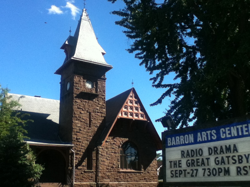
Barron Library
Monument and historic site · National Register of Historic Places · 3.2 mi
Historic building in Woodbridge, New Jersey

Crane-Phillips House
Monument and historic site · National Register of Historic Places · 3.5 mi
House in Cranford, New Jersey

Homestead Farm at Oak Ridge
Monument and historic site · National Register of Historic Places · 3.4 mi
Historic house at Oak Ridge Park, New Jersey

John De Camp House
Monument and historic site · National Register of Historic Places · 3.5 mi
Historic house in New Jersey, United States

Merchants and Drovers Tavern
Monument and historic site · National Register of Historic Places · 0.7 mi
Historic building in Union County, New Jersey

Robinson Plantation House
Monument and historic site · National Register of Historic Places · 1.6 mi
Historic house in New Jersey, United States


Droeschers Mill
Monument and historic site · National Register of Historic Places · 3.2 mi
Parks, trails and playgrounds25


General Casimir Pulaski Memorial Park
Park · 2.0 mi
301 West Munsell Avenue, Linden

13 more on the map.
Restaurants and cafes48


Copacabana Coffee & Bagles
Cafe · Bagel, Coffee Shop
77 East Milton Avenue, Rahway
Mo-Fr 06:00-16:00; Sa-Su 07:00-16:00
CubaNu Restaurant & Lounge
Restaurant · Cuban · 0.4 mi
1467 Main Street, Rahway
Su,Mo 14:00-22:00, Tu,We 11:00-23:30, Th 11:00-24:00, Fr...
Luciano's Ristorante
Restaurant · Italian, American · 0.4 mi
1579 Main Street, Rahway
We,Th 15:30-21:00; Fr 11:30-22:00; Sa 15:30-22:00; Su 15:30-21:00;...
Michelino's Pizzaria
Restaurant · Pizza
79 East Milton Avenue, Rahway
Mo-Th 10:00-22:00; Fr-Sa 10:00-23:00; Su 11:00-22:00
Nancy's Townehouse
Restaurant · Italian, Pizza · 0.4 mi
1453 Main Street, Rahway
Tu-Th 12:00-21:00; Fr 12:00-22:00; Sa 16:00-22:00; Su 16:00-21:00;...
il a forno a legna
Restaurant · Pizza, Italian
1464 Main Street, Rahway
Mo-Tu 11:00-21:00; We-Sa 11:00-22:00; Su 11:00-21:00
Espressito Cafe
Cafe · 1.2 mi
60 Westfield Avenue, Clark
Mo-Fr 07:00-16:00; Sa 08:00-16:00; Su 09:00-14:00

Flynn's Pub House
Bar and pub
1482 Main Street, Rahway
Mo closed; Tu-Th 16:00-24:00; Fr-Sa 11:00-25:00, Su 09:00-20:00
The Waiting Room
Restaurant
66 East Cherry Street, Rahway
Mo-Th 11:00-24:00; Fr 11:00-25:00, Sa 11:00-26:00; Su 11:00-24:00
Wet Ticket Brewery
Bar and pub · 0.4 mi
1435 Main Street, Rahway
We 17:00-21:00; Th 16:00-21:00; Fr 16:00-22:00; Sa 12:00-22:00; Su...
36 more on the map.
Where to stay14
Churches and places of worship22
First Presbyterian Church
Church · National Register of Historic Places · 3.2 mi
Trinity Episcopal Church
Church · National Register of Historic Places · 3.2 mi
Second Presbyterian Church
Church · Presbyterian · 0.4 mi
1221 New Brunswick Avenue, Rahway
Shopping11
Gas and EV charging14
Schools, colleges and libraries56
Academy For Urban Leadership Charter School
School · 6.0 mi
612 Amboy Ave, Perth Amboy
Admiral William F. Halsey Jr. Health & Public Safety Academy
School · 5.1 mi
641 South Street, Elizabeth
Healthcare3
Passport Health Clark Travel Clinic
Clinic and pharmacy · 1.7 mi
57 Brant Avenue, Clark
Map of Rahway
202 places. The map loads OpenStreetMap tiles when you open it.
Climate by month
Monthly table
| Month | High | Low | Rain | Snow |
|---|---|---|---|---|
| Jan | 40°F | 25°F | 3.7 in | 7.0 in |
| Feb | 43°F | 27°F | 3.3 in | 8.2 in |
| Mar | 51°F | 33°F | 4.4 in | 5.0 in |
| Apr | 62°F | 43°F | 4.0 in | 0.3 in |
| May | 72°F | 52°F | 4.2 in | 0.0 in |
| Jun | 81°F | 62°F | 4.5 in | 0.0 in |
| Jul | 86°F | 68°F | 5.3 in | 0.0 in |
| Aug | 84°F | 66°F | 4.1 in | 0.0 in |
| Sep | 77°F | 59°F | 4.2 in | 0.0 in |
| Oct | 66°F | 47°F | 4.4 in | 0.0 in |
| Nov | 55°F | 38°F | 3.6 in | 0.1 in |
| Dec | 45°F | 30°F | 4.5 in | 5.7 in |
U.S. Climate Normals 1991-2020 for Cranford (5 mi away), NOAA NCEI.
People and cost of living
American Community Survey 5-year estimates, 2020-2024, U.S. Census Bureau. Estimates have margins of error, larger for small towns.
Disaster history
Union County has had 18 federal disaster declarations since 2000, most often for hurricanes.
- 2021-09-05: Remnants Of Hurricane Ida (Hurricane)
- 2021-09-02: Remnants Of Hurricane Ida (Hurricane)
- 2020-03-25: Covid-19 Pandemic (Biological)
- 2020-03-13: Covid-19 (Biological)
- 2016-03-14: Severe Winter Storm And Snowstorm (Severe Storm)
- 2012-10-30: Hurricane Sandy (Hurricane)
OpenFEMA disaster declarations summaries.
Getting there and nearby towns
Linden Airport (LDJ) is the nearest airport with scheduled flights listed in OpenStreetMap, 2 miles away.
- Avenel 2 mi south, about 3 min by car
- Colonia 2 mi southwest, about 3 min by car
- Linden 3 mi northeast, about 4 min by car
- Carteret 3 mi southeast, about 5 min by car
- Iselin 3 mi southwest, about 5 min by car
- Roselle Park 4 mi north, about 7 min by car
- Fords 5 mi south, about 8 min by car
- Elizabeth 6 mi northeast, about 10 min by car
- Perth Amboy 6 mi south, about 10 min by car
- Metuchen 6 mi southwest, about 10 min by car
Drive times are estimates from straight-line distance, not routes.
Local news
Headlines from INDB, the NEMICO news database.
Reviews, tips and questions
Loading what members have shared...
Sources and licences
- NCES EDGE (Public domain): public schools
- NOAA NCEI U.S. Climate Normals 1991-2020 (Public domain): climate by month
- OpenFEMA (Public domain): disaster declarations
- OpenStreetMap contributors (ODbL 1.0): places, airports, map data
- U.S. Census Bureau (Public domain): population, income, housing, education, commute
- Wikidata (CC0 1.0): elevation, founding date, time zone, website, landmarks and historic places
- Wikimedia Commons (see each image): photos
- Wikipedia (CC BY-SA 4.0): overview and history text
Photo credits
- MerchantsAndDrovers, KForce at en.wikipedia, CC BY-SA 3.0
- NJT North Jersey Coast Line train 7249 approaching Rahway station July 2026, 4300streetcar, CC BY 4.0
- Rahway theatre, PeterMac13, CC BY-SA 3.0
- Rahway Wikivoyage banner, Ray Mtz, CC BY-SA 3.0
- Rahway, NJ City Hall, Nov. 2025, Mr. Matté (if there is an issue with this image, contact me using this image's Commons talk page , my Commons user talk page , or my English Wikipedia user talk page ; I'll know about it a lot faster), CC BY-SA 4.0
- Greetings from Rahway, New Jersey - Large Letter Postcard (8207137782), Steve Shook from Moscow, Idaho, USA, CC BY 2.0
- Rahway, NJ Fire Headquarters, Nov. 2025, Mr. Matté (if there is an issue with this image, contact me using this image's Commons talk page , my Commons user talk page , or my English Wikipedia user talk page ; I'll know about it a lot faster), CC BY-SA 4.0
- 2021-09-20 11 44 14 View east along Union County Route 514 (Grand Avenue) from the overpass for the rail line between Bridge Street and Elizabeth Avenue in Rahway, Union County, New Jersey, Famartin, CC BY-SA 4.0
- 2021-09-20 11 35 15 View west along Union County Route 514 (Grand Avenue) from the overpass for the rail line between Bridge Street and Elizabeth Avenue in Rahway, Union County, New Jersey, Famartin, CC BY-SA 4.0
- 2018-06-20 09 52 05 View east along Union County Route 514 (Elizabeth Avenue) between Union County Route 613 (Grand Avenue) and Jackson Avenue in Rahway, Union County, New Jersey, Famartin, CC BY-SA 4.0
- 2018-06-20 10 31 38 View west along Union County Route 514 (Grand Avenue) at Bridge Street in Rahway, Union County, New Jersey, Famartin, CC BY-SA 4.0
- 2018-06-20 09 47 31 View east along Union County Route 514 (Grand Avenue) just east of Lawrence Street in Rahway, Union County, New Jersey, Famartin, CC BY-SA 4.0
- 2018-06-20 10 36 17 View west along Union County Route 514 (Lawrence Street) just west of Union County Route 613 (Grand Avenue) in Rahway, Union County, New Jersey, Famartin, CC BY-SA 4.0
- NJ Route 27 sb at West Meadow Avenue, Rahway, Oct. 2026, Mr. Matté (if there is an issue with this image, contact me using this image's Commons talk page , my Commons user talk page , or my English Wikipedia user talk page ; I'll know about it a lot faster), CC BY-SA 4.0
- Second Baptist Church, Rahway, NJ, Dec. 2024, Mr. Matté (if there is an issue with this image, contact me using this image's Commons talk page , my Commons user talk page , or my English Wikipedia user talk page ; I'll know about it a lot faster), CC BY-SA 4.0
- 2018-06-20 18 30 36 View south along New Jersey State Route 27 (Saint Georges Avenue) just south of Union County Route 613 (Westfield Avenue-Grand Avenue) in Rahway, Union County, New Jersey, Famartin, CC BY-SA 4.0
- 2018-06-20 10 29 27 View west along Union County Route 514 (Elizabeth Avenue) between Union County Route 652 (Scott Avenue) and Jackson Avenue in Rahway, Union County, New Jersey, Famartin, CC BY-SA 4.0
- Rahway, NJ 07065, USA - panoramio, Ray Mtz, CC BY-SA 3.0
- 2018-06-20 09 41 06 View east along Union County Route 514 (Lawrence Street) at Hancock Street in Rahway, Union County, New Jersey, Famartin, CC BY-SA 4.0
- Tavern Rahway, Jared Kofsky/Placenj.com, CC BY-SA 3.0
- River Road wb, Rahway, NJ, Dec. 2024, Mr. Matté (if there is an issue with this image, contact me using this image's Commons talk page , my Commons user talk page , or my English Wikipedia user talk page ; I'll know about it a lot faster), CC BY-SA 4.0
- 2021-09-20 11 11 26 View west along Union County Route 514 (Lawrence Street) from the overpass for U.S. Route 1 and U.S. Route 9 in Rahway, Union County, New Jersey, Famartin, CC BY-SA 4.0
- 2021-09-20 11 19 47 View east along Union County Route 514 (Lawrence Street) from the overpass for U.S. Route 1 and U.S. Route 9 in Rahway, Union County, New Jersey, Famartin, CC BY-SA 4.0
- 2018-06-20 14 00 01 View north along New Jersey State Route 27 (Saint Georges Avenue) at Orchard Street in Rahway, Union County, New Jersey, Famartin, CC BY-SA 4.0
- 2021-05-26 11 26 27 View along the ramp connecting U.S. Route 1-U.S. Route 9 southbound to Union County Route 514 (Lawrence Street) in Rahway, Union County, New Jersey, Famartin, CC BY-SA 4.0
- 2020-07-24 09 23 16 View south along U.S. Route 1 and U.S. Route 9 at the exit for Union County Route 514 (Rahway, Woodbridge) in Rahway, Middlesex County, New Jersey, Famartin, CC BY-SA 4.0
- 2018-06-20 13 31 57 View north along U.S. Route 1 and U.S. Route 9 (Edgar Road) just north of Randolph Avenue in Rahway, Union County, New Jersey, Famartin, CC BY-SA 4.0
- 2016-03-12 15 29 21 View east along East Milton Avenue from U.S. Route 1 and U.S. Route 9 (U.S. Route 1&9) in Rahway, New Jersey, Famartin, CC BY-SA 4.0
- 2018-06-20 13 27 45 View south along U.S. Route 1 and U.S. Route 9 (Edgar Road) between Union County Route 613 (Grand Avenue) and Union County Route 608 (Milton Avenue) in Rahway, Union County, New..., Famartin, CC BY-SA 4.0
- Rahway River Park, NJ, Dec. 2024, Mr. Matté (if there is an issue with this image, contact me using this image's Commons talk page , my Commons user talk page , or my English Wikipedia user talk page ; I'll know about it a lot faster), CC BY-SA 4.0
- Crane-PhilipsHouse, KForce at English Wikipedia, CC BY-SA 3.0
- WilliamRobinsonPlantationHouse, KForce at en.wikipedia, CC BY-SA 3.0
- First Presbyterian Church of Woodbridge, Perrycart, CC BY-SA 3.0
- Trinity Episcopal Church, Woodbridge, NJ - south west view, Zeete, CC BY-SA 4.0
- HOMESTEAD FARM AT OAK RIDGE, MIDDLESEX COUNTY, NJ, Jerrye & Roy Klotz, MD, CC BY-SA 4.0
- Barron Arts Center-Barron Library, Perrycart, CC BY-SA 3.0
- JOHN DeCAMP HOUSE, UNION COUNTY, NJ, JERRYE & ROY KLOTZ MD, CC BY-SA 4.0
- DROESCHERS MILL, CRANFORD, UNION COUNTY, JERRYE & ROY KLOTZ MD, CC BY-SA 4.0
- Sabu January 2015, https://www.flickr.com/photos/10542402@N06/, CC BY-SA 2.0
- Trent Barretta Januay 2015, https://www.flickr.com/photos/10542402@N06/, CC BY-SA 2.0


Page built October 30, 2026. Spotted a mistake? Tell us or suggest a place.