
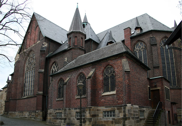


Why visit Waltrop
Townapedia lists 78 museums and landmarks, 36 parks and trails, 184 places to eat, 10 places to stay and 22 attractions in and around town.
Highlights include Halde Brockenscheidt, Spurwerkturm, Altes Schiffshebewerk and LWL-Industriemuseum Schiffshebewerk Henrichenburg.
Weather in Waltrop
Forecast from MET Norway (CC BY 4.0). Full forecast
About Waltrop
Waltrop (German pronunciation: [ˈvaltʁɔp] ) is a town in the district of Recklinghausen, in North Rhine-Westphalia, Germany. It is situated on the Datteln-Hamm Canal, approximately 15 km east of Recklinghausen and 15 km north-west of Dortmund.
From the Wikipedia article Waltrop (this version), under CC BY-SA 4.0.
Travel tips from other travellers: Waltrop on Wikivoyage (CC BY-SA 4.0).
Photos of Waltrop


Things to do22



Wulhorst
Farm and orchard · 2.3 km
184 Tinkhofstraße, Waltrop
Tu-Fr 08:30-18:30; Sa 08:00-17:00; Su 10:00-12:00

Westfälisches Landestheater
Cinema and theater · 8.8 km
Theater in Germany
Wulhorst
Farm and orchard · 2.6 km
3 Unterlippe, Waltrop
Mo-Fr 09:00-12:00, 14:00-17:00; Sa 09:00-13:00; Su 10:00-12:00

10 more on the map.
Museums and landmarks78

Altes Schiffshebewerk
Monument and historic site · 5.3 km
Hebewerk mit Trog ca. 70x9x2.5m, Hubhöhe 14m (ab den 1950 Jahren 13.50m)
5 Am Hebewerk, Waltrop
LWL-Industriemuseum Schiffshebewerk Henrichenburg
Museum · 5.3 km
26 Am Hebewerk, Waltrop
Tu-Su 10:00-18:00; PH 10:00-18:00
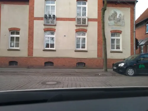
Bergarbeiter-Wohnmuseum
Museum · 4.2 km
10 Rudolfstraße, Lünen
Th 17:00-19:00; Tu,Su 15:00-17:00


Colani-Ufo
Monument and historic site · 3.9 km
17 Am Brambusch, Lünen

ehem. Flak-Stellung
Monument and historic site · 5.3 km
Ehemalige Flakstellung in Lünen-Alstedde während des 2. Weltkriegs zum Schutz der nahegelegenen Industrieanlagen: Lippewerk, Kraftwerke...

Schiffshebewerk Henrichenburg
Monument and historic site · 4.7 km
Ausgelegt für Europaschiffe mit 85m Länge, 11.4m Breite und 2.5m Tiefgang


Bunkermuseum unter der Halde Emscher Lippe
Museum · 4.9 km
26 Heibeckstraße, Datteln
Tu,Th 15:00-17:00
Ausstellungshalle Wasserstraßen u. Schifffahrt
Museum · 4.9 km
1 Zum Neuen Hebewerk
Tu-Sa 10:00-14:00; Su,PH 14:00-18:00
66 more on the map.
Parks, trails and playgrounds36




Yachtclub Hebewerk Henrichenburg
Marina and boat launch · 5.6 km
24 more on the map.
Restaurants and cafes184
Hafen Restaurant
Restaurant · Regional · 4.9 km
129 Hafenstraße
We-Sa 11:30-14:30, 17:30-22:00; Su 11:30-22:00
Piccola Enzo
Restaurant · Pizza · 5.8 km
17 Siegburgstraße, Dortmund
Mo-Sa 12:00-22:00; Su,PH 13:00-22:00

Johnny Canone - Mexican Cantina & Cocktailbar
Restaurant · Mexican · 5.4 km
5 Hohe Straße, Datteln
Mo-Sa 17:00+; Su 15:00+
Am Pütt
Restaurant · 1.1 km
58 Tinkhofstraße, Waltrop
We, Th 16:00-22:00; Fr, Sa 16:00-23:00; Su 12:00-21:00

Landgasthaus Klaukenhof
Restaurant · German · 5.8 km
Innenbereich teilweise barrierefrei, ebenerdiger Zugang
51 Pelkumer Weg, Datteln
172 more on the map.
History
The village developed around the parish church of St. Peter which was built in the 9th/10th century.
It is known that in 1432 Waltrop was a part of the county Dortmund. After the Soest Feud, the archbishops of Cologne could intervene against the counts of Mark, so that Waltrop became a part of Vest Recklinghausen.
The production of coal in the mine started in 1905. As a consequence, Waltrop grew larger and became an industrial town. One coal mine was closed down in 1979, the other closed in 1992.
From the History section of Waltrop on Wikipedia, under CC BY-SA 4.0.
Notable people from Waltrop
 Alexander BaumjohannGerman footballerPhoto: DerHans04, CC BY-SA 3.0
 Frank SchwabeGerman politicianPhoto: Foto-AG Gymnasium Melle, CC BY 3.0
- Sylvia DördelmannGerman rower
- Christoph KorteGerman rower
- Michel LewandowskiFrench and Polish association football player (1914-1990)
Born in Waltrop, according to Wikidata (CC0). Each name links to its Wikipedia article.
Where to stay10
Churches and places of worship28
St. Antonius
Church · Roman Catholic · 5.4 km
66 Ickerner Straße, Castrop-Rauxel
Evangelische St. Remigius-Kirche Mengede
Church · Protestant · 5.3 km
Shopping56
Gas and EV charging25
Schools, colleges and libraries37
Overberg Grundschule (kath.)
School · Roman Catholic · 5.6 km
5 Am Hohen Teich, Dortmund
Healthcare26
Map of Waltrop
250 places. The map loads OpenStreetMap tiles when you open it.
Getting there and nearby towns
Dortmund Airport (DTM) is the nearest airport with scheduled flights listed in OpenStreetMap, 19 km away.
- Datteln 6 km northwest, about 6 min by car
- Mengede 6 km south, about 6 min by car
- Brechten 7 km southeast, about 7 min by car
- Oestrich 7 km south, about 7 min by car
- Lünen 9 km east, about 9 min by car
- Westerfilde 9 km south, about 9 min by car
- Castrop-Rauxel 10 km southwest, about 10 min by car
- Selm 10 km northeast, about 10 min by car
- Lindenhorst 9 km south, about 9 min by car
- Oer-Erkenschwick 10 km west, about 10 min by car
Drive times are estimates from straight-line distance, not routes.
Towns near Waltrop


Keep exploring
Local news
Headlines from INDB.
Reviews, tips and questions
Loading what members have shared...
Sources and licences
- GeoNames (CC BY 4.0): population, coordinates, regions and time zone
- Mapillary (see each image): photos
- OpenStreetMap contributors (ODbL 1.0): places, airports, map data
- Wikidata (CC0 1.0): elevation, founding date, time zone, website, landmarks and historic places
- Wikimedia Commons (see each image): photos
- Wikipedia (CC BY-SA 4.0): overview and history text
Photo credits
- 04 2006 Waltrop st Peter, Lutz Mischa Heitmüller, Bonn, Germany, Attribution
- Stolperstein Waltrop Dortmunder Straße 33 Bertha Rosenthal, Gmbo 2013, CC0
- Stolperstein Waltrop Dortmunder Straße 54 Bertha Rosenblum, Gmbo 2013, CC0
- Stolpersteine Waltrop Dortmunder Straße 54, Gmbo 2013, CC0
- Stolpersteine Waltrop vor Dortmunder Straße 54, Gmbo 2013, CC0
- Stolperstein Waltrop Dortmunder Straße 54 Leo Rosenblum, Gmbo 2013, CC0
- Waltrop Monument 32 Bauernhaus Dortmunder Str 55 2019-09-21, W.Strickling, CC BY-SA 4.0
- Stolpersteinlage Waltrop Dortmunder Straße 54, Gmbo 2013, CC0
- Waltrop Monument 34 Arztvilla Dortmunder Str 50 2019-09-21, W.Strickling, CC BY-SA 4.0
- Stolpersteine Waltrop vor Dortmunder Straße 33, Gmbo 2013, CC0
- Stolpersteinlage Waltrop Dortmunder Straße 33, Gmbo 2013, CC0
- Stolperstein Waltrop Dortmunder Straße 33 Ruth Rosenthal, Gmbo 2013, CC0
- Stolperstein Waltrop Dortmunder Straße 33 Ingeborg Rosenthal, Gmbo 2013, CC0
- Stolperstein Waltrop Dortmunder Straße 33 Meta Rosenthal, Gmbo 2013, CC0
- Stolperstein Waltrop Dortmunder Straße 33 Josef Rosenthal, Gmbo 2013, CC0
- Stolperstein Waltrop Dortmunder Straße 33 Willi Rosenthal, Gmbo 2013, CC0
- Stolpersteine Waltrop Dortmunder Straße 33, Gmbo 2013, CC0
- Waltrop Monument 11 Kornbrennerei 2019-09-21, W.Strickling, CC BY-SA 4.0
- Waltrop Kiepenkerl, Arnoldius, CC BY-SA 4.0
- Stolpersteine Waltrop Rösterstraße 2, Gmbo 2013, CC0
- Stolpersteine Waltrop vor Rösterstraße 2, Gmbo 2013, CC0
- Stolperstein Waltrop Rösterstraße 2 Helmut Baum, Gmbo 2013, CC0
- Stolperstein Waltrop Rösterstraße 2 Marta Baum, Gmbo 2013, CC0
- Stolperstein Waltrop Rösterstraße 2 Jakob Baum, Gmbo 2013, CC0
- Stolperstein Waltrop Rösterstraße 2 Werner Baum, Gmbo 2013, CC0
- Stolperstein Waltrop Rösterstraße 2 Günter Baum, Gmbo 2013, CC0
- Stolpersteinlage Waltrop Rösterstraße 2, Gmbo 2013, CC0
- Waltrop Monument 03 Bissenkamp 23 2019-09-21, W.Strickling, CC BY-SA 4.0
- Waltrop Monument 02 Tempel Kirchplatz 5 2019-09-21, W.Strickling, CC BY-SA 4.0
- Waltrop Monument 05 Bissenamp 21 2019-09-21, W.Strickling, CC BY-SA 4.0
- Waltrop Monument 10 Bissenkamp 19 2019-09-21, W.Strickling, CC BY-SA 4.0
- Uhrwerk St Peter 2019-09-21 Waltrop-0924, Dr. W. Strickling, CC BY-SA 4.0
- Waltrop Monument 12 St Peter Suedseite 2019-09-21, W.Strickling, CC BY-SA 4.0
- Waltrop Monument 15 Bissenkamp 14 2019-09-21, W.Strickling, CC BY-SA 4.0
- Waltrop Monument 09 Bissenkamp 17 2019-09-21, W.Strickling, CC BY-SA 4.0
- Waltrop Monument 06 Gasthof Burbaum 2019-09-21, W.Strickling, CC BY-SA 4.0
- Waltrop Petrusbrunnen, Arnoldius, CC BY-SA 4.0
- Waltrop St Peter tower, Arnoldius, CC BY-SA 4.0
- Waltrop Monument 12 St Peter Werktagskapelle 2019-09-21, W.Strickling, CC BY-SA 4.0
- Waltrop Monument 12 St Peter Marienkapelle 2019-09-21, W.Strickling, CC BY-SA 4.0
- Henrichenburg, Nordrhein-Westfalen - Schiffshebewerk (2) (Zeno Ansichtskarten), Cramers Kunstanstalt, Dortmund, Public domain
- Forum BK Ostvest, Bkostvest, CC BY-SA 3.0
- Luenen Colani UFO, Wolfgang Hunscher, Dortmund, CC BY-SA 3.0
- Dortmund Remigiuskirche, A.Savin, CC BY-SA 3.0
- Waltrop - Landabsatz - Halde Brockenscheidt 07 ies, Frank Vincentz, CC BY-SA 3.0
- Datteln Museum, Stahlkocher, CC BY-SA 3.0
- Ickern Kath.Kirche St.Antonius, ludger1961 ( talk · contribs ), CC BY-SA 3.0
- Dortmund Volksgarten Mengede 1, User:Stahlkocher, CC BY-SA 3.0
- Flakvierling-38-20mm-hatzerim-1, No machine-readable author provided. Bukvoed assumed (based on copyright claims)., CC BY 2.5
- Coal mine Waltrop Spurwerkturm 1, Arnoldius, CC BY-SA 3.0
- Evangelische Lutherkirche Datteln 2019-09-21, Dr. W. Strickling, CC BY-SA 4.0
- St. Remigius Mengede Dortmund-1720, User:Creosoph, CC BY-SA 4.0
- Neues Schiffshebewerk Henrichenburg, Raimond Spekking, CC BY-SA 4.0
- Datteln Monument Friedenskirche Provinzialstrasse, W.Strickling, CC BY-SA 4.0
- Naturschutzgebiet Groppenbruch 001, Itti, CC BY-SA 3.0
- Naturschutzgebiet Herrentheyer Wald (Holzkamp) 002, Itti, CC BY-SA 3.0
- Dortmund Im Siesack DO 013 -0001, Kramernyc, CC BY-SA 4.0
- Leveringhauser Vogelteich, Tbachner, CC BY-SA 3.0
- LippePanorama, Wolfgang Armbrüster , Solingen, CC BY-SA 2.0 de
- Naturschutzgebiet Mengeder Heide 005, Itti, CC BY-SA 3.0
- Street-level photo, saschahaberkorn, CC BY-SA 4.0
- Street-level photo, m1map, CC BY-SA 4.0
- Street-level photo, awaya, CC BY-SA 4.0
- Street-level photo, poxonline, CC BY-SA 4.0
- Street-level photo, mfa, CC BY-SA 4.0
- Street-level photo, poxonline, CC BY-SA 4.0
- Street-level photo, changchun1, CC BY-SA 4.0
- Street-level photo, descilla, CC BY-SA 4.0
- Street-level photo, chateaureblaus, CC BY-SA 4.0
- Street-level photo, chateaureblaus, CC BY-SA 4.0
- Street-level photo, m1map, CC BY-SA 4.0
- Street-level photo, bct, CC BY-SA 4.0
- Street-level photo, saschahaberkorn, CC BY-SA 4.0
- Street-level photo, saschahaberkorn, CC BY-SA 4.0
- Street-level photo, awaya, CC BY-SA 4.0
- Street-level photo, changchun1, CC BY-SA 4.0
- Street-level photo, poxonline, CC BY-SA 4.0
- Street-level photo, changchun1, CC BY-SA 4.0
- Street-level photo, saschahaberkorn, CC BY-SA 4.0
- Street-level photo, mapnrw, CC BY-SA 4.0
- Street-level photo, poxonline, CC BY-SA 4.0
- Street-level photo, descilla, CC BY-SA 4.0
- Street-level photo, mapnrw, CC BY-SA 4.0
- Street-level photo, poxonline, CC BY-SA 4.0
- Street-level photo, changchun1, CC BY-SA 4.0
- Street-level photo, awaya, CC BY-SA 4.0


Page built November 9, 2026. Spotted a mistake? Tell us or suggest a place.