


Why visit Belford
Townapedia lists 3 museums and landmarks, 2 parks and trails, 4 places to eat, 8 places to stay and 2 attractions in and around town.
Highlights include Belford War Memorial.
Weather in Belford
Forecast from MET Norway (CC BY 4.0). Full forecast
About Belford
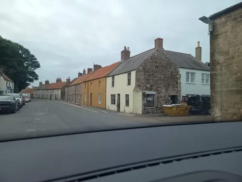
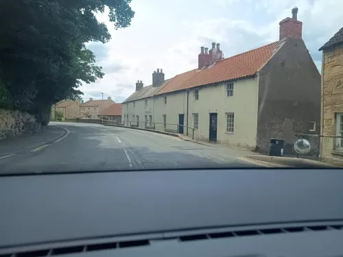
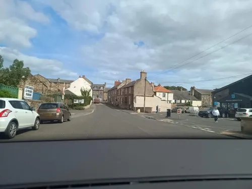
Belford is a village and civil parish in Northumberland, England, about halfway between Alnwick and Berwick-upon-Tweed, around 4 km inland from the east coast and just off the Great North Road, the A1. At the 2001 census it had a population of 1,055, increasing to 1,258 at the 2011 Census.
From the Wikipedia article Belford, Northumberland (this version), under CC BY-SA 4.0.
Things to do2

Museums and landmarks3

Parks, trails and playgrounds2

Restaurants and cafes4
Black Swan
Bar and pub
Church Street, Belford
Mo-Th 15:00-22:00+; Fr 15:00-23:00+; Sa,Su 12:00-23:00+
The John Dory Fish & Chip Shop
Fast food · Fish And Chips
8 West Street, Belford
Th 17:00-20:00, Fr 12:00-02:00,17:00-20:00, Sa 17:00-20:00
History
For much of the Middle Ages, Belford was at the forefront of the ongoing border conflict between the Scots and the English and it is believed that only Well House escaped damage or destruction at the hands of Scottish raiders. In 1272 it is recorded that Walter de Huntercombe, the Lord of the Manor, was charged with 'assisting pirates'. They had seized, by force, goods belonging to some wealthy Spanish merchants and landed with their booty on Holy Island.
In 1726, A wealthy city merchant, Abraham Dixon bought the Belford Estate. He made improvements which enhanced the fortunes of its inhabitants significantly including purchasing a licence in 1742 allowing him to hold a weekly market and two annual fairs at Belford. His son continued improvements after his death in 1746 and by 1770, a visitor was able to report the existence of a woollen mill, a tannery, collieries and a 'large lime kiln'. Improvements to hygiene were also imposed upon the inhabitants with the forced removal of muck heaps from the houses and the banning of swine.
Larger market towns have gradually replaced Belford in importance and the location of the station outside of the town itself did nothing to halt a gradual decline in its fortunes since the end of the 19th century. Many of the features of its heyday have been retained however.
From the History section of Belford, Northumberland on Wikipedia, under CC BY-SA 4.0.
More about Belford
Education
St Mary's Church of England Voluntary Aided Middle School in Williams Way, Belford provides mainstream education for just under 100 boys and girls aged from nine to thirteen.
From the Wikipedia article Belford, Northumberland, under CC BY-SA 4.0.
Notable people from Belford
- William ColdstreamBritish painter and teacher (1908-1987)
- Michael ClarkCanadian politician
- Arthur Cuthbertson(1901-1979)
Born in Belford, according to Wikidata (CC0). Each name links to its Wikipedia article.
Where to stay8
Churches and places of worship1
Shopping5
Schools, colleges and libraries1
Healthcare1
Map of Belford
27 places. The map loads OpenStreetMap tiles when you open it.
Getting there and nearby towns
Newcastle International Airport (NCL) is the nearest airport with scheduled flights listed in OpenStreetMap, 39 miles away.
- North Sunderland 7 mi east, about 11 min by car
- Berwick-Upon-Tweed 13 mi northwest, about 22 min by car
- Longhoughton 14 mi southeast, about 23 min by car
- Lesbury 16 mi southeast, about 26 min by car
- Shilbottle 17 mi south, about 27 min by car
- Warkworth 19 mi southeast, about 31 min by car
- East Chevington 24 mi southeast, about 39 min by car
- Morpeth 30 mi south, about 49 min by car
- Ashington 31 mi south, about 50 min by car
- Blyth 35 mi south, about 56 min by car
Drive times are estimates from straight-line distance, not routes.
Towns near Belford


Keep exploring
Local news
Headlines from INDB.
Reviews, tips and questions
Loading what members have shared...
Sources and licences
- GeoNames (CC BY 4.0): population, coordinates, regions and time zone
- Mapillary (see each image): photos
- OpenStreetMap contributors (ODbL 1.0): places, airports, map data
- Wikidata (CC0 1.0): elevation, founding date, time zone, website
- Wikimedia Commons (see each image): photos
- Wikipedia (CC BY-SA 4.0): overview and history text
Photo credits
- Middleton Hall Northumberland, Zjdalton, CC BY-SA 3.0
- Market Cross In Front Of Blue Bell Hotel Belford, Outwivcamera, CC BY-SA 4.0
- Street-level photo, zuse, CC BY-SA 4.0
- Street-level photo, zuse, CC BY-SA 4.0
- Street-level photo, zuse, CC BY-SA 4.0
- Street-level photo, zuse, CC BY-SA 4.0
- Street-level photo, zuse, CC BY-SA 4.0
- Street-level photo, zuse, CC BY-SA 4.0
- Street-level photo, zuse, CC BY-SA 4.0
- Street-level photo, zuse, CC BY-SA 4.0
- Street-level photo, zuse, CC BY-SA 4.0
- Street-level photo, zuse, CC BY-SA 4.0
- Street-level photo, zuse, CC BY-SA 4.0
- Street-level photo, zuse, CC BY-SA 4.0
- Street-level photo, zuse, CC BY-SA 4.0
- Street-level photo, zuse, CC BY-SA 4.0
- Street-level photo, zuse, CC BY-SA 4.0
- Street-level photo, zuse, CC BY-SA 4.0
Page built November 10, 2026. Spotted a mistake? Tell us or suggest a place.