


Lostwithiel, United Kingdom
Lostwithiel is a town of 2,659 people in England, United Kingdom.
Why visit Lostwithiel
Townapedia lists 10 museums and landmarks, 5 parks and trails, 14 places to eat, 2 places to stay and 1 attraction in and around town.
Highlights include Respryn Bridge, Restormel Castle, Lanhydrock House and Red Moor nature reserve.
Weather in Lostwithiel
Forecast from MET Norway (CC BY 4.0). Full forecast
About Lostwithiel
Lostwithiel (; Cornish: Lostwydhyel [lɔstˈwɪðjɛl] , meaning wooded tail) is a town and civil parish in Cornwall, England, United Kingdom. It stands at the head of the estuary of the River Fowey. At the 2021 census, the population of the parish was 3,070. The name Lostwithiel comes from the Cornish "lostwydhyel" which means "tail of a wooded area".
From the Wikipedia article Lostwithiel (this version), under CC BY-SA 4.0.
Travel tips from other travellers: Lostwithiel on Wikivoyage (CC BY-SA 4.0).
Photos of Lostwithiel


Things to do1
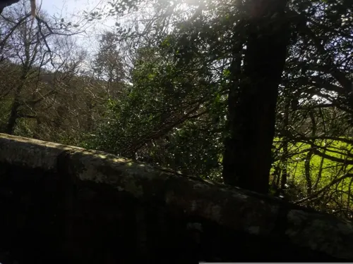
Respryn Bridge
Bridge · 2.3 mi
15th century bridge over the River Fowey in Cornwall, England, UK
Museums and landmarks10

Restormel Castle
Monument and historic site · 1.0 mi
Castle, now ruinous, north of Lostwithiel, Cornwall, England, UK

Lanhydrock House
Museum · 2.6 mi
Country house in Lanhydrock, Cornwall, England, UK



Lesquite Quoit
Monument and historic site · 2.7 mi
Portal dolmen in Lanivet, Cornwall, England, UK
Parks, trails and playgrounds5

Red Moor nature reserve
Park · 2.1 mi
Nature reserve near Lanlivery in mid Cornwall, England, UK


Restaurants and cafes14

Earl of Chatham
Bar and pub
39 Grenville Road, Lostwithiel
Mo-Tu 15:00-23:00; We-Th 12:00-23:00; Fr-Sa 09:00-23:00; Su 12:00-21:00
Q Street Coffee
Cafe · Sandwich
22 Queen Street
Mo-Fr 09:30-16:00; Sa 09:30-15:00; Su 09:30-14:00


Moonlight Tandoori Indian Restaurant
Restaurant · Indian, Tandoori
35 Fore Street, Lostwithiel

2 more on the map.
History
Lostwithiel was founded in the 12th century by Norman lords who built the nearby Restormel Castle. Lostwithiel received its town charter in 1189. It was initially laid out as a pair of adjoining boroughs: Penknight or Penkneth to the south of South Street, which was founded by Robert de Cardinham as lord of the manor, and Lostwithiel to the north of South Street, founded by the Earls of Cornwall. Lostwithiel formally absorbed Penkneth in 1268. In the late 13th century, Edmund, 2nd Earl of Cornwall oversaw the building of the Stannary Palace, the bridge and the square church tower.
The Battle of Lostwithiel, an important battle in the First English Civil War, took place near Lostwithiel in 1644. In it Parliamentarian forces were defeated by the Royalists. The Parliamentarians would go on to win the war but Cornwall remained under Royalist control until 1646.
Jaques Bagratuni, a prince and ambassador of Armenia to Britain, died in Lostwithiel on 23 December 1943 but was buried at Brompton Cemetery in London.
Read more of the history
The Trinity Iron Mine was founded in the 1790s to mine haematite iron ore. In 1797 Philip Rashleigh found a sample of goethite here. Following a visit by Queen Victoria and Prince Albert it was renamed to the Royal Restormel Iron Mine in 1846. A horse-drawn tramway ran from the mine, to the old cattle market in the centre of town and on to the Town Quay on the River Fowey. Up to 120 people were employed in the mine and it produced 4,500 tons of ore annually. The mine closed in 1883.
From the History section of Lostwithiel on Wikipedia, under CC BY-SA 4.0.
More about Lostwithiel
Geography
The town is situated in the Fowey river valley, positioned between the A390 road from Tavistock to Truro and the upper tidal reaches of the river.
Lostwithiel railway station is on the Cornish Main Line from Plymouth to Penzance. It is situated on the south side of the town, just across the medieval bridge. The line was originally built for the Cornwall Railway which built its main workshops here, but the surviving workshop buildings were transformed into apartments in 2004. A branch line takes china clay trains to Fowey.
The town contains the suburbs of Bridgend to the east and Rosehill and Victoria to the west of the River Fowey.
To the south of the town is the Shirehall Moor nature reserve which follows the course of the River Fowey and opens out to a wide salt marsh. The reserve is a haven for birdlife including swans, ducks, egrets, herons, kingfishers and Canada geese.
Arts and culture
The town has a playing field known as King George V Playing Field. Lostwithiel has several large parks including Coulson Park which was named after Nathaniel Coulson (the San Francisco property magnate) who was raised in Lostwithiel after being abandoned by his father.
The town is host to a number of annual cultural activities including an arts and crafts festival, a beer festival, a week-long carnival in the summer, food and cider festivals in October, and a Dickensian evening in December.
Education
There are two primary schools in Lostwithiel: St Winnow C E School and Lostwithiel Primary School. Both schools are academies. Lostwithiel Primary School is part of the Peninsula Learning Trust Multi Academy Trust and St Winnow C E School is part of The Saints Way Multi Academy Trust. The majority of children aged between 11 and 16 attend Fowey River Academy or Bodmin College.
Lostwithiel Educational Trust is a local charity which makes "grants to local schools and churches, as well as to individuals, for educational purposes"
From the Wikipedia article Lostwithiel, under CC BY-SA 4.0.
Notable people from Lostwithiel
 Andy MackayBritish musicianPhoto: Raph_PH, CC BY 2.0
- Arthur Moyle, Baron MoyleBritish politician (1894-1974)
- Charles HerleEnglish theologian
- Stephen VarcoeEnglish bass-baritone
- Frances Margery HextBritish historian
- Kate JacksonBritish mixed martial arts (MMA) fighter
- Charles Staniforth HextBritish military officer and artist
Born in Lostwithiel, according to Wikidata (CC0). Each name links to its Wikipedia article.
Where to stay2
Churches and places of worship9
Shopping13
Schools, colleges and libraries4
Healthcare1
Map of Lostwithiel
59 places. The map loads OpenStreetMap tiles when you open it.
Getting there and nearby towns
Cornwall Airport Newquay (NQY) is the nearest airport with scheduled flights listed in OpenStreetMap, 14 miles away.
- Bodmin 5 mi northwest, about 8 min by car
- Fowey 5 mi south, about 8 min by car
- St Austell 6 mi southwest, about 10 min by car
- Roche 7 mi west, about 12 min by car
- Polperro 8 mi southeast, about 14 min by car
- Mevagissey 11 mi southwest, about 17 min by car
- Saint Stephen 11 mi southwest, about 18 min by car
- Pensilva 13 mi northeast, about 21 min by car
- Camelford 15 mi north, about 24 min by car
- Padstow 15 mi northwest, about 24 min by car
Drive times are estimates from straight-line distance, not routes.
Towns near Lostwithiel


Keep exploring
Local news
Headlines from INDB.
Reviews, tips and questions
Loading what members have shared...
Sources and licences
- GeoNames (CC BY 4.0): population, coordinates, regions and time zone
- Mapillary (see each image): photos
- OpenStreetMap contributors (ODbL 1.0): places, airports, map data
- Wikidata (CC0 1.0): elevation, founding date, time zone, website, landmarks and historic places
- Wikimedia Commons (see each image): photos
- Wikipedia (CC BY-SA 4.0): overview and history text
Photo credits
- Lostwithiel, Matnkat, CC BY 3.0
- Golden Dynasty chinese takeaway shopfront, Lostwithiel, Cornwall - May 2024, Mutney, CC0
- Queen Street, Lostwithiel, Cornwall - February 2026 (1), Mutney, CC BY 4.0
- Golden Dynasty chinese takeaway, Lostwithiel, Cornwall - May 2024 (1), Mutney, CC0
- 12 Queen Street, Lostwithiel, Cornwall - February 2026, Mutney, CC BY 4.0
- The Coronet hairdressers, Queen Street, Lostwithiel, Cornwall - February 2026, Mutney, CC BY 4.0
- Lostwithiel (2021-09-05) 43, Simon Cobb, CC0
- Lostwithiel (2021-09-05) 45, Simon Cobb, CC0
- Lostwithiel (2021-09-05) 44, Simon Cobb, CC0
- Lostwithiel (2021-09-05) 46, Simon Cobb, CC0
- Lostwithiel (2021-09-05) 42, Simon Cobb, CC0
- 16 North Street, Lostwithiel, Cornwall - February 2026, Mutney, CC BY 4.0
- Golden Dynasty chinese takeaway, Lostwithiel, Cornwall - May 2024 (2), Mutney, CC0
- Duke Street, Lostwithiel, Cornwall - February 2026, Mutney, CC BY 4.0
- Plaque on house on North Street, Lostwithiel, Cornwall - May 2024, Mutney, CC0
- Lostwithiel (2021-09-05) 49, Simon Cobb, CC0
- North Street, Lostwithiel, Cornwall - February 2026 (8), Mutney, CC BY 4.0
- Tudor Bridge (Ancient Bridge) in Lostwithiel, Cornwall – Photo by Ben Hawkins, BenHawkinsPhotography, CC BY-SA 4.0
- 17 North Street, Lostwithiel, Cornwall - February 2026, Mutney, CC BY 4.0
- 18 North Street, Lostwithiel, Cornwall - February 2026 (1), Mutney, CC BY 4.0
- Lostwithiel (2021-09-05) 48, Simon Cobb, CC0
- Lostwithiel (2021-09-05) 47, Simon Cobb, CC0
- Lostwithiel (2021-09-05) 37, Simon Cobb, CC0
- Lostwithiel (2021-09-05) 38, Simon Cobb, CC0
- Lostwithiel (2021-09-05) 39, Simon Cobb, CC0
- Lostwithiel (2021-09-05) 40, Simon Cobb, CC0
- Lostwithiel (2021-09-05) 41, Simon Cobb, CC0
- Buildings in North Street, Lostwithiel, Cornwall - February 2026, Mutney, CC BY 4.0
- Buildings on Queen Street, Lostwithiel, Cornwall - May 2024, Mutney, CC0
- Lostwithiel (2021-09-05) 31, Simon Cobb, CC0
- RestormelCastle, Zaian at English Wikipedia, Public domain
- Lanhydrock (2759114593), Tony Hisgett from Birmingham, UK, CC BY 2.0
- St Winnow Parish Church, Keithpoole at English Wikipedia, Public domain
- Lostwithiel (2021-09-04) 19, Simon Cobb, CC0
- St Nectan's Chapel, DuncanHill, CC BY-SA 4.0
- The Earl of Chatham pub, Grenville Road, Lostwithiel, Cornwall - February 2026, Mutney, CC BY 4.0
- Street-level photo, WaggyDog, CC BY-SA 4.0
- Street-level photo, WaggyDog, CC BY-SA 4.0
- Street-level photo, WaggyDog, CC BY-SA 4.0
- Street-level photo, WaggyDog, CC BY-SA 4.0
- Street-level photo, WaggyDog, CC BY-SA 4.0
- Street-level photo, WaggyDog, CC BY-SA 4.0
- Street-level photo, WaggyDog, CC BY-SA 4.0
- Street-level photo, WaggyDog, CC BY-SA 4.0
- Street-level photo, WaggyDog, CC BY-SA 4.0
- Street-level photo, WaggyDog, CC BY-SA 4.0
- Street-level photo, WaggyDog, CC BY-SA 4.0
- Street-level photo, WaggyDog, CC BY-SA 4.0
- Street-level photo, WaggyDog, CC BY-SA 4.0
- Street-level photo, WaggyDog, CC BY-SA 4.0
- Street-level photo, WaggyDog, CC BY-SA 4.0
- Street-level photo, WaggyDog, CC BY-SA 4.0
- Street-level photo, WaggyDog, CC BY-SA 4.0
- Street-level photo, WaggyDog, CC BY-SA 4.0


Page built November 10, 2026. Spotted a mistake? Tell us or suggest a place.