


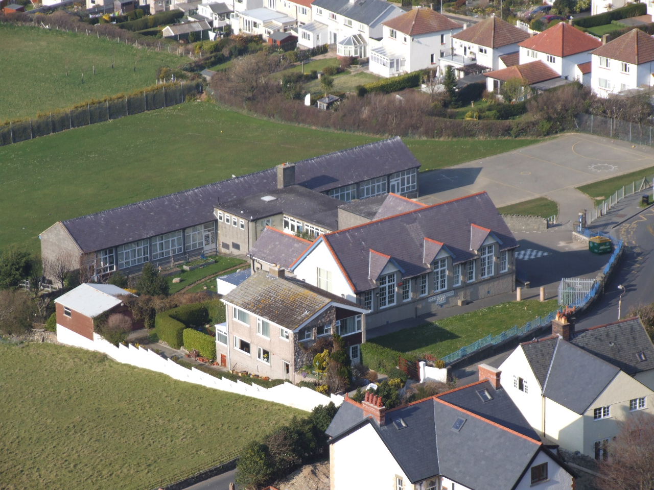


Penmaenmawr, United Kingdom
Penmaenmawr is a town of 2,535 people in Wales, United Kingdom.
Why visit Penmaenmawr
Townapedia lists 10 museums and landmarks, 7 parks and trails, 25 places to eat, 9 places to stay and 11 attractions in and around town.
Highlights include Foel Lus, Foel Lwyd, Braich-y-Ddinas and Maen Penddu.
Weather in Penmaenmawr
Forecast from MET Norway (CC BY 4.0). Full forecast
About Penmaenmawr
Penmaenmawr (, Welsh: [ˈpɛnmaːɨnmaur] ) is a town and community in Conwy County Borough, Wales, which was formerly in the parish of Dwygyfylchi and the traditional county of Caernarfonshire. It is on the North Wales coast between Conwy and Llanfairfechan and was an important quarrying town, though quarrying is no longer a major employer. The population of the community was 4,353 in 2011, including Dwygyfylchi and Capelulo. The town itself having a population of 2,868 (2011).
From the Wikipedia article Penmaenmawr (this version), under CC BY-SA 4.0.
Things to do11



Museums and landmarks10

Braich-y-Ddinas
Monument and historic site · 0.8 mi
Destroyed large hillfort above Penmaenmawr, Conwy Burough Council, Wales


Parks, trails and playgrounds7




Restaurants and cafes25

Beach Cafe
Cafe · Regional, Sandwich, Coffee Shop · 0.5 mi
Promenade, Penmaenmawr
Mo-Su 10:00-17:00

Llanfairfechan Sailing Club
Bar and pub · 2.0 mi
Promenade, Llanfairfechan
Tu-Th,Su 17:00-22:00; Fr 17:00-24:00; Sa 17:00-23:00
13 more on the map.
History
The uplands above the town have many prehistoric remains, including the site of prehistoric polished stone axe factories on the west slopes of Cwm Graiglwyd near the top of Penmaen-mawr. This was once one of the most important stone axe manufacturing sites in Europe, together with the Langdale axe industry in the Lake District, Tievebulliagh in County Antrim and other sites across Britain.
There is evidence that axes from Graiglwyd were exported widely 5,000 years ago, examples having been found as far afield as Cornwall and south-east England. The nearby Meini Hirion, known in English as Druid's Circle, is a prehistoric stone circle. Archaeological excavations have discovered the cremated remains of children at the site. A prehistoric trackway from Bwlch-y-ddeufaen to Conwy runs by the circle. The summit of Penmaen-mawr, from which the town takes its name, was 1,500 feet (460 m) above sea level until reduced by modern quarrying. The summit area was crowned by Braich-y-Dinas, one of the largest Iron Age hillforts in Europe, comparable with Tre'r Ceiri near Trefor on the Llŷn peninsula. However, nothing remains today; the last remnants were obliterated by quarrying in the 1920s.
Read more of the history
According to tradition, the 5th or 6th century saint Seiriol, after whom Ynys Seiriol, the Welsh name for Puffin Island or Priestholme, is named, had a hermit's cell in Cwm Graiglwyd. A declivity, Clipyn Seiriol, above the modern road tunnel through Penmaenmawr, also bears his name, as does the modern church of St Seiriol's near the town centre. The older church of St Gwynin's in Dwygyfylchi is the parish church today. Penmaenmawr is also associated with Saint Ulo, Capelulo being at the foot of Sychnant and reputedly the site of an early medieval chapel.
From the early Middle Ages onwards the parish has been part of Arllechwedd Uchaf, and this ancient Welsh cwmwd (English: commote), which together with neighbouring Arllechwedd Isaf makes up the cantref (hundred) of Arllechwedd, is still used by the church as an administrative unit today.
The industrial quarrying of igneous rock (diorite) at Penmaenan began in 1830 with the opening of the Penmaen Quarry and the subsequent, competing Graiglwyd and "Old" quarries which were amalgamated by 1888 under Colonel Darbishire. Most of the production in these early years was of setts and paving, but from 1881 the advantage of crushed rock for railway ballast was demonstrated and new crushing mills were built to provide for that market. In 1911 Darbishire merged these operations with the quarries of Trefor to form the Penmaenmawr & Welsh Granite Co. As the industry grew, workers and their families flocked to Penmaenmawr from all over north-west Wales and beyond. The link was especially strong with Trefor, the home of Trefor granite quarry on the slopes of Yr Eifl. The community which sprang up in the present-day wards of Penmaenan and Pant-yr-afon was close-knit and almost entirely Welsh-speaking. By the early years of the 20th century about 1,000 men worked in the quarry and its associated workshops. Neighbouring Llanfairfechan was an integral part of this process.
The quarried stone was lowered by self-acting inclines to the 3-foot (910 mm) gauge tramway which ran to jetties from where the setts were loaded into ships. After 1848 the majority of the quarry output was sent by main-line rail, although the quarry and its internal narrow gauge railway continued to operate through the 19th century.
Life was not easy for the quarrymen, especially those who worked on the higher slopes. They were expected to walk up to the summit area in all weathers and faced losing pay if unable to reach the top. A strong spirit of camaraderie developed and was reflected in the town's chapels, pubs and cultural societies. Products were exported by rail to ports such as Liverpool and the cities of England and by sea from the two quarrying jetties to Liverpool and also to a number of European ports such as Hamburg. Ships continued to load cargoes from the Darbishire jetty until 1976, although sea trade had been sparse since the famous stranding of the Rethi Muller in 1967. Railway ballast continued to move in quantity from the sidings near the station, but all the original infrastructure was swept away by the building of the new A55 Expressway in the late 1980s. A new rail-loading facility was constructed and the original sidings space used for the new road. In 2008 the contract for the supply of railway ballast to Network Rail was lost, and since that time there have only been limited movements by rail – such as for construction of the Manchester Metrolink extensions. This quarrying over time removed the whole top of Penmaenmawr mountain, which was once much higher with a rounded top, with an old hill-fort.
The town grew in popularity as a seaside resort for the well-to-do in the second half of the 19th century, in part due to the enthusiasm shown by statesman and Prime Minister William Ewart Gladstone who holidayed eleven times in Penmaenmawr between 1855 and 1896. Since then the A55 has separated the seaside from the town and the population and tourism have declined.
From the History section of Penmaenmawr on Wikipedia, under CC BY-SA 4.0.
More about Penmaenmawr
Geography
The villages that make up Penmaenmawr are Penmaenan and Pant Yr Afon on the west and Dwygyfylchi and Capelulo on the east. They are on a small coastal plain about 2 miles (3.2 km) long and half a mile deep facing Conwy Bay and the Irish Sea to the north. The bay is sheltered by the south-east tip of Anglesey and Puffin Island to the north-west and the limestone headland of Pen-y-Gogarth (the Great Orme) to the north-east. The sea is shallow here between Traeth Lafan and the Conwy estuary. The beach is extensive, consisting of smooth pebbles and a wide expanse of sand; it was awarded a Blue Flag for five years running.
Two headlands separate Penmaenmawr from its neighbours. In the west, the bulk of Penmaen Mawr lies between the town neighbouring Llanfairfechan and the wider coastal plain extending to Bangor. To the east, the smaller but no less rugged headland of Penmaen Bach divides Dwygyfylchi from Conwy Morfa.
Education
Ysgol Pencae provides Welsh-medium primary education to the village and the surrounding area. As of 2025, there were 155 pupils enrolled at the school. A third of pupils speak Welsh at home.
From the Wikipedia article Penmaenmawr, under CC BY-SA 4.0.
Notable people from Penmaenmawr
 Matthew Hughesbadminton playerPhoto: Peter Saxon, CC BY-SA 4.0
- Gareth RobertsBritish physicist (1940-2007)
- Innes LloydBritish television producer (1925-1991)
Born in Penmaenmawr, according to Wikidata (CC0). Each name links to its Wikipedia article.
Where to stay9
Churches and places of worship10
Shopping6
Gas and EV charging1
Schools, colleges and libraries6
Healthcare3
Map of Penmaenmawr
88 places. The map loads OpenStreetMap tiles when you open it.
Getting there and nearby towns
RAF Valley - Anglesey Airport (VLY) is the nearest airport with scheduled flights listed in OpenStreetMap, 25 miles away.
- Llandudno 6 mi northeast, about 9 min by car
- Tregarth 8 mi southwest, about 13 min by car
- Colwyn Bay 9 mi east, about 14 min by car
- Bangor 9 mi west, about 14 min by car
- Abergele 15 mi east, about 23 min by car
- Rhyl 19 mi east, about 30 min by car
- Rhuddlan 19 mi east, about 31 min by car
- Saint Asaph 20 mi east, about 32 min by car
- Penygroes 21 mi southwest, about 33 min by car
- Prestatyn 22 mi east, about 36 min by car
Drive times are estimates from straight-line distance, not routes.
Towns near Penmaenmawr


Keep exploring
Local news
Headlines from INDB.
Reviews, tips and questions
Loading what members have shared...
Sources and licences
- GeoNames (CC BY 4.0): population, coordinates, regions and time zone
- Mapillary (see each image): photos
- OpenStreetMap contributors (ODbL 1.0): places, airports, map data
- Wikidata (CC0 1.0): elevation, founding date, time zone, website, landmarks and historic places
- Wikimedia Commons (see each image): photos
- Wikipedia (CC BY-SA 4.0): overview and history text
Photo credits
- Chapel (Reused) Penmaenmawr (25194760735), grassrootsgroundswell, CC BY 2.0
- Braich-y-Dinas (sgan o hen lun yn 'Archaeologia Cambrensis', 1877) destroyed hillfort in Wales, Unknown author Unknown author, Public domain
- Ysgol Capelulo 01, User:Anatiomaros, Public domain
- Maen Penddu a'r ardal gerllaw - Maen Penddu and surrounding area, nr Henryd, Dyffryn Conwy, Cymru (Wales) 21, Llywelyn2000, CC BY-SA 4.0
- Moel Llys, Penmaenmawr, Sears Bros, CC0
- Moelfre hill - N-E of the Carneddau, Wales 44, Llywelyn2000, CC BY-SA 4.0
- Mynydd y Foel Lwyd, ger Penmaenmawr o'r Gog-Orll, Sir Conwy 04, Llywelyn2000, CC BY-SA 4.0
- Clip yr Orsedd (429m) overlooking Penmaenmawr quarries, from the S - Sir Conwy county, Wales 05, Llywelyn2000, CC BY-SA 4.0
- Street-level photo, santon, CC BY-SA 4.0
- Street-level photo, trigpoint, CC BY-SA 4.0
- Street-level photo, malenki, CC BY-SA 4.0
- Street-level photo, santon, CC BY-SA 4.0
- Street-level photo, santon, CC BY-SA 4.0
- Street-level photo, santon, CC BY-SA 4.0
- Street-level photo, malenki, CC BY-SA 4.0
- Street-level photo, malenki, CC BY-SA 4.0
- Street-level photo, malenki, CC BY-SA 4.0
Page built November 10, 2026. Spotted a mistake? Tell us or suggest a place.