




Why visit Ryhope
Townapedia lists 10 museums and landmarks, 15 parks and trails, 23 places to eat and 9 attractions in and around town.
Highlights include Wearmouth Bridge, Monkwearmouth Bridge, National Glass Centre and Sunderland Museum and Winter Gardens.
Weather in Ryhope
Forecast from MET Norway (CC BY 4.0). Full forecast
About Ryhope
Ryhope is a coastal village along the southern boundary of the City of Sunderland, in Tyne and Wear, England. With a population of approximately 14,000, measured at 10.484 in the 2011 census, Ryhope is 2.9 miles to the centre of Sunderland, 2.8 miles to the centre of Seaham, and 1.2 miles from the main A19.
From the Wikipedia article Ryhope (this version), under CC BY-SA 4.0.
Photos of Ryhope

Things to do9

Wearmouth Bridge
Bridge · 2.7 mi
Grade II listed through arch bridge in Sunderland, Tyne and Wear, England, UK


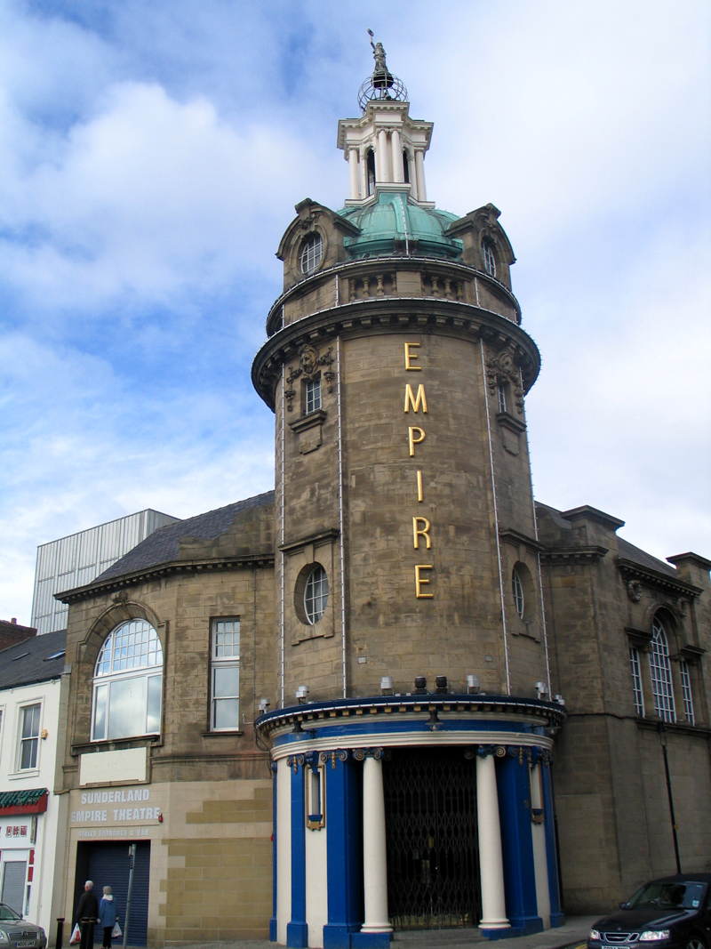
Sunderland Empire Theatre
Cinema and theater · 2.5 mi
Theatre in Sunderland, England

Museums and landmarks10

National Glass Centre
Museum · 2.9 mi
Glass museum in Sunderland, Tyne and Wear

Sunderland Museum and Winter Gardens
Museum · 2.3 mi
Museum in Sunderland, Tyne and Wear, United Kingdom



Dalden Tower
Monument and historic site · 2.9 mi
Tower in Seaham, County Durham, England, UK
Northern Gallery for Contemporary Art
Museum · 2.8 mi
Building in England, UK
Parks, trails and playgrounds15

Tunstall Hills
Park · 1.2 mi
Urban open space and nature reserve in Sunderland, Tyne and Wear, England, UK



Doxford International Business Park
Park · 2.6 mi
Business park in the UK
Town Moor, Sunderland
Park · 2.5 mi
Park in Sunderland, United Kingdom



3 more on the map.
Restaurants and cafes23



11 more on the map.
History
Ryhope (from the Old English reof hoppas, meaning "rough valley") is first mentioned in 930 AD when king Athelstan granted the land of Bishopwearmouth (including the township of Ryhope) to the Bishop of Chester-le-Street. The land had been reclaimed from the Vikings who had captured it in 918 AD.
Ryhope has a strong history of farming; in 1183 there were 22 recorded villeins who provided the landowner with cattle and crops. In 1380 the population had swelled to approximately 150. In 1860 common grazing land was split into plots, which radiated out in strips from the village green. Ryhope's proximity to the sea has allowed it to serve as a seaside destination for centuries. The beach is said to have been a favourite sea-bathing spot for the Bishop of Durham.
Read more of the history
Located on the Durham coalfield, Ryhope followed the path of many other villages in the area, and abandoned agriculture as the main employer in favour of coal. In 1859 a colliery was opened, causing huge changes in the geography of the village. The settlement of Ryhope extended west toward the area of Tunstall, creating two distinct areas of Ryhope; the 'Village' and the 'Colliery' (the post-World War II, council-built estate of 'Hollycarrside' forms a third section.) Railway lines were introduced to the area, linking Ryhope to Sunderland, Seaham and other Durham Coalfield mining villages. Now only a single railway line runs through the village, and there is no longer a station. The colliery was closed in 1966.
A bronze statue of a pit pony was erected on a plinth on the Stockton Road entrance to Ryhope in 2009 by the Ryhope Development Trust. The statue was stolen for a second time in October 2021; its subsequently replacement with toys, teddy bears and rocking horses gained viral popularity online in 2023. In August 2024, a second, separate metal statue of a pit pony was also stolen.
In March 1944 Ryhope was the scene of the conclusion of the epic last flight of the Handley Page Halifax bomber LK797 from RAF Bomber Command's raid on Nuremberg, which crash-landed in Ryhope, resulting in Pilot Officer Cyril Barton being posthumously awarded the Victoria Cross.
From the History section of Ryhope on Wikipedia, under CC BY-SA 4.0.
More about Ryhope
Geography
The A1018 'Southern Radial Route', which opened in 2008, bypasses Ryhope along the clifftops and takes traffic toward the Port of Sunderland in Hendon and other routes to the centre and north of Sunderland.
The B1287 Sea View Road links Ryhope with the town of Seaham to the south.
Ryhope is surrounded by farmland meaning it is a relatively isolated suburb of Sunderland. A number of cycle routes run through the village, including the National Cycle Network Route number 1 which is looked after by a local team of Sustrans Rangers.
Located to the south-west of the village is Cherry Knowle Hospital which is part of the South of Tyne and Wearside Mental Health NHS Trust. It has long been the main mental health services complex for the Wearside area. The Ryhope Engines Museum is also located in this area.
Ryhope was part of the Houghton and Washington East constituency until its abolition at the 2010 general election. Since then, it has formed part of the Sunderland Central constituency.
Ryhope was formerly a township and chapelry in the parish of Bishop-Wearmouth, in 1866 Ryhope became a separate civil parish, on 1 April 1967 the parish was abolished and merged with Sunderland and Seaham. In 1961 the parish had a population of 9796.
Arts and culture
Ryhope Engines Museum, which is based on the Ryhope Pumping Station, was built in 1868 to supply water to the Sunderland area.
Among natural features, Ryhope adjoins Tunstall Hills which have views of the city of Sunderland and beyond (on a clear day, down the coast almost to Whitby). The Tunstall Hills are located on the southern outskirts of Sunderland between (New) Silksworth and Ryhope. The disused quarries and cuttings at Tunstall Hills provide exposure through part of the Magnesian Limestone succession of Permian age. The slopes on the "Maiden Paps" section support species such as blue moor-grass, common rock-rose, perennial flax and locally uncommon plants such as Frog Orchid, Autumn Gentian and Purple Milk-Vetch. These areas have been designated a "site of special scientific interest" (SSSI).
Ryhope is also home to the world's first (and so far only) listed Pigeon Cree.
From the Wikipedia article Ryhope, under CC BY-SA 4.0.
Notable people from Ryhope
- Billy DownEnglish footballer (1898-1977)
- Owen WilliamsEnglish footballer (1896-1960)
- Harry Cockerillassociation football player (1894-1960)
- Joe RobsonFootballer born 1899
- Ronald RaddBritish actor (1929–1976)
- Thomas BarrowCanadian politician (1916-1982)
- George Goodchildassociation football player (1875-1927)
- Joe NicholsonEnglish footballer (1898-1974)
- Allan Grahamassociation football player
- Richie Pittprofessional footballer (born 1951)
- Bobby MaltEnglish footballer (born 1951)
- Tommy MycockFootballer (1923-1988)
Born in Ryhope, according to Wikidata (CC0). Each name links to its Wikipedia article.
Churches and places of worship14
St Leonard's RC
Church · Roman Catholic · 1.1 mi
Tunstall Village Road, Sunderland
Shopping3
Gas and EV charging1
Schools, colleges and libraries14
St Leonard's Catholic Primary School
School · Roman Catholic · 1.1 mi
Tunstall Village Road, Sunderland
Healthcare3
St. Benedict’s Hospice and Centre for Specialist Palliative Care
Hospital · 0.6 mi
St. Benedict's Way, Ryhope
Map of Ryhope
92 places. The map loads OpenStreetMap tiles when you open it.
Getting there and nearby towns
Newcastle International Airport (NCL) is the nearest airport with scheduled flights listed in OpenStreetMap, 17 miles away.
- Sunderland 2 mi north, about 4 min by car
- Seaham 2 mi southeast, about 4 min by car
- Murton 4 mi south, about 6 min by car
- Newcastle upon Tyne 12 mi northwest, about 19 min by car
- Whickham 13 mi northwest, about 21 min by car
- Spennymoor 15 mi southwest, about 24 min by car
- Middlesbrough 21 mi south, about 34 min by car
- Thornaby-on-Tees 24 mi south, about 38 min by car
- Yarm 25 mi south, about 41 min by car
- Whitby 40 mi southeast, about 1 h by car
Drive times are estimates from straight-line distance, not routes.
Towns near Ryhope


Keep exploring
Local news
Headlines from INDB.
Reviews, tips and questions
Loading what members have shared...
Sources and licences
- GeoNames (CC BY 4.0): population, coordinates, regions and time zone
- OpenStreetMap contributors (ODbL 1.0): places, airports, map data
- Wikidata (CC0 1.0): elevation, founding date, time zone, website, landmarks and historic places
- Wikimedia Commons (see each image): photos
- Wikipedia (CC BY-SA 4.0): overview and history text
Photo credits
- NCN Millennium Milepost MP191 Ryhope Sunderland, Richard Webb, CC BY-SA 2.0
- Pont ferroviaire Wear Sunderland 6, Chabe01, CC BY-SA 4.0
- Queen Alexandra Bridge, John-Paul Stephenson, CC BY-SA 3.0
- Sunderland Empire, Unknown author, Public domain
- National Glass Centre, aariops, CC BY-SA 2.0
- SunderlandWinterGardens, Sterock85 https://www.flickr.com/photos/35000357@N07/, CC BY 3.0
- BarnesPark, Sunderland Renaissance, CC BY-SA 4.0
- Bandstand - Mowbray Park, Craigy144 at English Wikipedia, CC BY-SA 3.0
- St' George's Church - panoramio, somaliayaswan, CC BY 3.0
- St Mary's Church, Sunderland, Tom Bastin, CC BY 2.0
- St Peter's Church-Monkwearmouth, R J McNaughton, CC BY-SA 2.0
- Ryhope, Elysium 73 at English Wikipedia, Public domain
- Rocky Hill, Tunstall, Craigy ( talk ), CC BY-SA 3.0
- 1995 Rover 114 GTa, E11.13ga, CC BY 4.0
- Wearmouth Bridge, Sunderland, Sandra, CC BY 2.0


Page built November 10, 2026. Spotted a mistake? Tell us or suggest a place.