
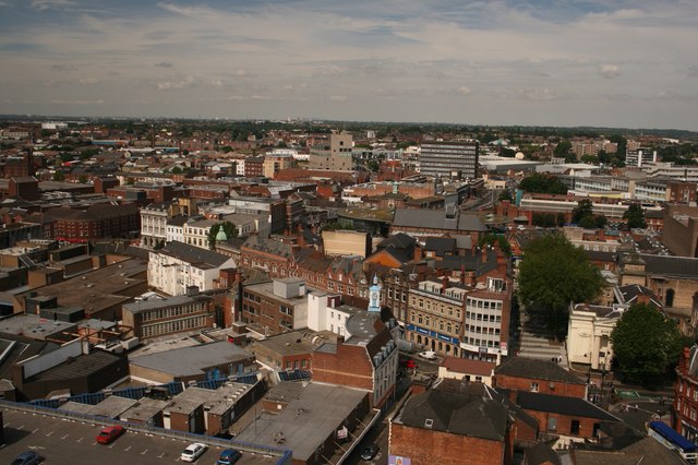


Why visit Walsall
Townapedia lists 30 museums and landmarks, 32 parks and trails, 161 places to eat, 10 places to stay and 4 attractions in and around town.
Highlights include The Light, Bishop Asbury Cottage, The New Art Gallery and Walsall Arboretum.
Weather in Walsall
Forecast from MET Norway (CC BY 4.0). Full forecast
About Walsall
Walsall (, locally ) is a market town and administrative centre of the Metropolitan Borough of Walsall, part of the Black Country in the West Midlands, England. Historically part of Staffordshire, it is located 9 miles (14 km) north-west of Birmingham, 7 miles (11 km) east of Wolverhampton and 9 miles (14 km) south-west of Lichfield.
From the Wikipedia article Walsall (this version), under CC BY-SA 4.0.
Travel tips from other travellers: Walsall on Wikivoyage (CC BY-SA 4.0).
Photos of Walsall


Things to do4


Museums and landmarks30
Bishop Asbury Cottage
Museum · 3.2 mi
Cottage in Sandwell, West Midlands, England, UK


The New Art Gallery Walsall
Museum
Modern and contemporary art gallery in Walsall, England, United Kingdom

Walsall Leather Museum
Museum
Municipal museum in Walsall, England, United Kingdom

Wednesbury Museum and Art Gallery
Museum · 2.9 mi
Art museum in Sandwell, West Midlands, United Kingdom



Locksmith's House
Museum · 3.2 mi
Museum in Willenhall, Staffordshire, England, United Kingdom

Walsall Castle
Monument and historic site · 0.7 mi
Manor house in Walsall, West Midlands, England
18 more on the map.
Parks, trails and playgrounds32

Walsall Arboretum
Park · 0.7 mi
Victorian public park located close to Walsall town centre in the West Midlands of England

Pallet-Track Bescot Stadium
Sports field and stadium · 1.4 mi
Bescot Crescent, Walsall

Brunswick Park
Park · 2.2 mi
Public park in Wednesbury, West Midlands, England, UK

Red House Park
Park · 3.2 mi
Public park in Great Barr, Sandwell, England
The Jane Lane History & Sensory Garden
Park · 1.4 mi
Garden and trail reflecting Jane Lane’s flight as she aided the escape of Charles II in the 1640′s. Totem poles have terracotta plaques...

20 more on the map.
Restaurants and cafes161


Kabel's Steakhouse
Cafe · Steak House
Tu-Fr 17:00-22:00; Sa 12:00-22:00; Su 12:00-17:00

149 more on the map.
History
The name Walsall is derived from "Walh halh", meaning "valley of the Welsh", referring to the Celtic Britons who first lived in the area. Later, it is believed that a manor was held here by William Fitz-Ansculf, who held numerous manors in the Midlands. By the first part of the 13th century, Walsall was a small market town with a manor house, Walsall Castle; the weekly market was introduced in 1220 and held on Tuesdays. The mayor of Walsall was created as a political position in the 14th century.
The Manor of Walsall was held by the Crown and given as a reward to royal proteges. In 1525, it was given to the King's illegitimate son, Henry Duke of Richmond, and in 1541 to the courtier Sir John Dudley, later Duke of Northumberland. It was seized by Queen Mary in 1553, after Northumberland had been found guilty of treason.
Queen Mary's Grammar School was founded in 1554 and the school carries the queen's personal badge as its emblem: the Tudor Rose and the sheaf of arrows of Mary's mother Catherine of Aragon tied with a Stafford knot.
The town was visited by Queen Elizabeth I, when it was known as 'Walshale'. It was also visited by Henrietta Maria in 1643. She stayed in the town for one night at a building named the 'White Hart' in the area of Caldmore.
Read more of the history
The Manor of Walsall was later sold to the Wilbraham and Newport families, and passed by inheritance to the Earls of Bradford. On the death of the fourth Earl in 1762, the estate was transferred to his sister Diana, Countess of Mountrath and then reverted to the Earls of Bradford until the estates were sold after World War II. The family's connection with Walsall is reflected in local placenames, including Bridgeman Street, Bradford Lane, Bradford Street and Mountrath Street.
The Industrial Revolution changed Walsall from a village of 2,000 people in the 16th century to a town of over 86,000 in approximately 200 years. The town manufactured a wide range of products including saddles, chains, buckles and plated ware. Nearby, limestone quarrying provided the town with much prosperity.
In 1824, the Walsall Corporation received an Act of Parliament to improve the town by providing lighting and a gasworks. The gasworks was built in 1826 at a cost of £4,000. In 1825, the corporation built eleven tiled, brick almshouses for poor women. They were known to the area as 'Molesley's Almshouses'.
The 'Walsall Improvement and Market Act' was passed in 1848 and amended in 1850. The Act provided facilities for the poor, improving and extending the sewerage system and giving the commissioners the powers to construct a new gas works. On 10 October 1847, a gas explosion killed one person and destroyed the west window of St Matthew's Church.
Walsall received a railway line in 1847, 48 years after canals reached the town, Bescot having been served since 1838 by the Grand Junction Railway. In 1855, Walsall's first newspaper, the Walsall Courier and South Staffordshire Gazette, was published.
The Whittimere Street drill hall was completed in 1866. The Victorian Arcade in the town centre, originally named the Digbeth Arcade, was completed in 1897.
Over 2,000 men from Walsall were killed in fighting during the First World War. They are commemorated by the town's cenotaph, which is located on the site of a bomb which was dropped by Zeppelin 'L 21', killing the town's mayoress and two others. Damage from the Zeppelin can still be seen on what is now a club on the corner of the main road, just opposite a furniture shop. A plaque commemorates the incident. The town also has a memorial to local VC recipient, John Henry Carless and decorated air ace Frederick Gibbs.
Walsall's first cinema opened in the town centre in 1908; however, the post-World War II decline in cinema attendances brought on by the rise in television ownership resulted in that and all of Walsall's other cinemas eventually being closed. The first Wurlitzer theatre organ in Great Britain was installed in the New Picture House cinema in Lower Bridge Street in the town centre. It was later renamed the Gaumont then Odeon.
Slum clearance began after the end of World War I, with thousands of 19th century buildings around the town centre being demolished as the 20th century wore on; new estates were built away from the town centre during the 1920s and 1930s. These were concentrated in areas to the north of the town centre such as Coal Pool, Blakenall Heath (where Walsall's first council houses were built in 1920), Goscote and Harden. after the end of World War II, Beechdale.
Significant developments also took place nearer to the town centre, particularly during the 1960s when a host of tower blocks were built around the town centre; however, most of these had been demolished by 2010.
The Memorial Gardens opened in 1952, in honour of the town's fallen combatants of the two world wars. The Old Square Shopping Centre, a modern indoor shopping complex featuring many big retail names, opened in 1969.
Much of the reconstruction of the post-war period was quickly reconsidered as ugly and having blighted the town. In 1959, John Betjeman advised that with sensitive restoration the old buildings of the High Street could become "one of the most attractive streets in England." Instead, almost every building was demolished.
The County Borough of Walsall, which was established at Walsall Council House and originally consisted of Walsall and Bloxwich, was expanded in 1966 to incorporate most of Darlaston and Willenhall, as well as small parts of Bilston and Wednesbury. The current Metropolitan Borough of Walsall was formed in 1974 when Aldridge-Brownhills Urban District was incorporated into Walsall. At the same time, Walsall was transferred from the historic county of Staffordshire to become part of the new West Midlands county.
From the History section of Walsall on Wikipedia, under CC BY-SA 4.0.
More about Walsall
Geography
A local landmark is Barr Beacon, which is reportedly the highest point following its latitude eastwards until the Ural Mountains in Russia. The soil of Walsall consists mainly of clay with areas of limestone, which were quarried during the Industrial Revolution.
Economy
Walsall has had many industries, from coal mining to metal working. In the late 19th century, the coal mines ran dry, and Walsall became internationally famous for its leather trade. Walsall manufactured Queen Elizabeth II handbags, saddles for the royal family and leather goods for King Charles III as Prince of Wales. Walsall is the traditional home of the English saddle manufacturing industry, hence the nickname of Walsall Football Club, "the Saddlers". Apart from leather goods, other industries in Walsall include iron and brass founding, limestone quarrying, small hardware, plastics, electronics, chemicals and aircraft parts.
Walsall's location in Central England and the fact that the M6 runs through the Metropolitan Borough of Walsall has increased its investment appeal. The main RAC control centre is located in Walsall close by J9 of the M6 and there are now plans to redevelop derelict land in nearby Darlaston and turn it into a state-of-the-art regional centre. Between Bloxwich and Walsall there is a business corridor where TK Maxx has recently opened a regional depot. Currently established businesses include Homeserve plc and South Staffordshire Water.
Arts and culture
Walsall Arboretum was officially opened on 4 May 1874 by the wealthy Hatherton family. It was hoped that the park would provide "a healthy change from dogfights, bull-baiting and cockfights"; however, the 2d (old pence) admission was not popular with the public and within seven years the council took over ownership to provide free admission. Among the attractions available were two boating lakes on the sites of former quarries, tennis courts, an outdoor swimming pool and later – in the extension – a children's play area and paddling pool.
Education
Walsall is home to the University of Wolverhampton's Sports and Art Campus and School of Education, all part of the Walsall Campus in Gorway Road, which includes a student village. Walsall College provides further education, and is based around three sites across Walsall. There are ten secular junior schools and three religious junior schools near the town centre. Walsall also houses many secondary schools, including comprehensives, academies, private and state grammar schools (Namely Queen Mary's Grammar School and Queen Mary's High School).
The age of transfer to secondary school throughout the borough is 11 years, although the Aldridge-Brownhills area of the borough had a system of 5–9 first, 9–13 middle and 13–18 secondary schools until 1986, as the former urban district council of this area had adopted the three-tier system in 1972.
Schools within the borough are administered by Walsall MBC.SERCO Archived 26 November 2011 at the Wayback Machine.
From the Wikipedia article Walsall, under CC BY-SA 4.0.
Notable people from Walsall
 Jorja SmithBritish singer, songwriter and musicianPhoto: Justin Higuchi from Los Angeles, CA, USA, CC BY 2.0
 Martin FowlerBritish programmerPhoto: Webysther Nunes, CC BY-SA 4.0
 John Byrneauthor and artist of comic booksPhoto: Luigi Novi, CC BY 4.0
 Noddy HolderEnglish musician and actor, songwriterPhoto: Andrew King, CC BY-SA 2.0
 Andrew ParrottBritish conductorPhoto: Wasily, Public domain
 Andy CEnglish musicianPhoto: Stephen West, CC BY 2.0
 Rachel UnittEnglish association football player (born 1982)Photo: Katie Chan, CC BY-SA 4.0
- Jerome K. JeromeEnglish humorist (1859-1927)
- John Edward GrayBritish zoologist (1800–1875)
- Michael FitzgeraldBritish Catholic cardinal (born 1937)
- GoldieBritish DJ and producer
- Arthur RussellBritish athlete (1886-1972)
Born in Walsall, according to Wikidata (CC0). Each name links to its Wikipedia article.
Where to stay10
Churches and places of worship73
The Crossing at Saint Paul's Church, Limited
Church · Anglican
Darwall Street, Walsall
Shopping34
Gas and EV charging6
Wolverhampton University Walsall Campus Electric Charge Point
EV charging · 1.1 mi
Schools, colleges and libraries44
St Thomas of Canterbury Catholic Primary School
School · Roman Catholic · 1.3 mi
Dartmouth Avenue, Walsall
Healthcare30
Map of Walsall
250 places. The map loads OpenStreetMap tiles when you open it.
Getting there and nearby towns
Birmingham Airport (BHX) is the nearest airport with scheduled flights listed in OpenStreetMap, 14 miles away.
- Bloxwich 2 mi north, about 4 min by car
- Darlaston 2 mi southwest, about 4 min by car
- Wednesbury 3 mi southwest, about 5 min by car
- Willenhall 3 mi west, about 5 min by car
- Aldridge 3 mi northeast, about 5 min by car
- Pelsall 3 mi north, about 5 min by car
- West Bromwich 5 mi south, about 7 min by car
- Wolverhampton 6 mi west, about 9 min by car
- Birmingham 8 mi southeast, about 13 min by car
- Worcester 29 mi south, about 47 min by car
Drive times are estimates from straight-line distance, not routes.
Towns near Walsall


Keep exploring
Local news
Headlines from INDB.
Reviews, tips and questions
Loading what members have shared...
Sources and licences
- GeoNames (CC BY 4.0): population, coordinates, regions and time zone
- Mapillary (see each image): photos
- OpenStreetMap contributors (ODbL 1.0): places, airports, map data
- Wikidata (CC0 1.0): elevation, founding date, time zone, website, landmarks and historic places
- Wikimedia Commons (see each image): photos
- Wikipedia (CC BY-SA 4.0): overview and history text
Photo credits
- Walsall in 2007, Derek Bennett, CC BY-SA 2.0
- Class 25 at Walsall, Tutenkhamun Sleeping, CC BY 2.0
- 44 + 46 Park Street, Walsall - 2002-10-04 - Andy Mabbett - 05, Andy Mabbett, CC BY-SA 4.0
- 44 + 46 Park Street, Walsall - 2002-10-04 - Andy Mabbett - 01, Andy Mabbett, CC BY-SA 4.0
- 44 + 46 Park Street, Walsall - 2002-10-04 - Andy Mabbett - 04, Andy Mabbett, CC BY-SA 4.0
- 44 + 46 Park Street, Walsall - 2002-10-04 - Andy Mabbett - 03, Andy Mabbett, CC BY-SA 4.0
- 44 + 46 Park Street, Walsall - 2002-10-04 - Andy Mabbett - 06, Andy Mabbett, CC BY-SA 4.0
- 44 + 46 Park Street, Walsall - 2002-10-04 - Andy Mabbett - 02, Andy Mabbett, CC BY-SA 4.0
- 44 + 46 Park Street, Walsall - 2002-10-04 - Andy Mabbett - 07, Andy Mabbett, CC BY-SA 4.0
- DR98924 at Walsall, Tutenkhamun Sleeping, CC BY 2.0
- 66091 at Walsall - 5326087351, Tutenkhamun Sleeping, CC BY 2.0
- Walsall railway station.p10, Ryan kirk, CC BY-SA 3.0
- All Saints Bloxwich, Martin Neylon, CC BY-SA 4.0
- St Bartholomew's Wednesbury, Brianboru100, CC BY-SA 3.0
- Walsall Leather Museum, Brianboru100, CC BY-SA 3.0
- WalsallF2Go, MikeMetaled at English Wikipedia, Public domain
- John Henry Carless VC - bust, Andy Mabbett, CC BY-SA 3.0
- Walsall Market Cross ASDA, Brianboru100, CC BY-SA 3.0
- Walsall vs Carlisle 02.01.2021, Khatton00, CC BY-SA 4.0
- Holbrook ,Walsall Arboretum - panoramio, shakestd, CC BY 3.0
- Walsall - Leather Museum, David Barnes, CC BY-SA 2.0
- New Art Gallery (34038621056), Alex Liivet from Chester, United Kingdom, CC0
- New Art Gallery Walsall - interior 11 - barrier tape, Andy Mabbett, CC BY-SA 3.0
- Wednesbury Museum and Art Gallery - Holyhead Road, Wednesbury (38535690832), Elliott Brown from Birmingham, United Kingdom, CC BY-SA 2.0
- Street-level photo, 4004, CC BY-SA 4.0
- Street-level photo, techie2000, CC BY-SA 4.0
- Street-level photo, techie2000, CC BY-SA 4.0
- Street-level photo, southglos, CC BY-SA 4.0
- Street-level photo, adam2, CC BY-SA 4.0
- Street-level photo, adam2, CC BY-SA 4.0
- Street-level photo, techie2000, CC BY-SA 4.0


Page built November 10, 2026. Spotted a mistake? Tell us or suggest a place.