


Westoning, United Kingdom
Westoning is a town of 2,147 people in England, United Kingdom.
Why visit Westoning
Townapedia lists 4 museums and landmarks, 5 parks and trails, 20 places to eat, 1 place to stay and 1 attraction in and around town.
Highlights include De Grey Mausoleum, Ruxox Cell, Fancott Woods and Meadows and Flitwick Moor.
Weather in Westoning
Forecast from MET Norway (CC BY 4.0). Full forecast
About Westoning
Westoning () is a village and civil parish in Bedfordshire, England. It is located around 0.5 miles (0.8 km) south of the town of Flitwick. The River Flit flows behind the Westoning stud farm.
From the Wikipedia article Westoning (this version), under CC BY-SA 4.0.
Things to do1

Museums and landmarks4

De Grey Mausoleum
Monument and historic site · 2.6 mi
Grade I listed building in Flitton, Central Bedfordshire, England, UK

Ruxox Cell
Monument and historic site · 2.3 mi
Moated site in Flitwick, Bedfordshire, England, UK

Parks, trails and playgrounds5

Fancott Woods and Meadows
Park · 3.1 mi
Nature reserve in the United Kingdom



Cooper's Hill
Park · 3.2 mi
Nature reserve in Bedfordshire, England, UK
Restaurants and cafes20

The Bell Inn
Restaurant · Thai
Pub and a thai resteraunt in the bell
High Street, Bedford
Cravin Coffee
Cafe · Coffee Shop · 1.5 mi
Mo-Fr 05:45-13:00; Sa 08:00-14:00; Su 07:00-13:00


The Hub & Spoke Café
Cafe · Coffee Shop, Pizza, Cake · 1.2 mi
6 Lincoln Way, Dunstable
Tu-Sa 09:00-17:00

8 more on the map.
History
The village is mentioned in the Domesday Book of 1086; men in the village (as heads of household or serfs) numbered 16 villagers (villeins), 3 smallholders and 4 slaves (serfs). Cultivated land amounted to 14 ploughlands (land for) two lord's plough teams, five men's plough teams. Other resources were 2.0 ploughs of lord's lands (private parkland), seven ploughs of meadow and woodland worth 400 pigs (annual turnover of swine livestock). The head manor was Hitchin, which was owned by the King.
Alternative names of the village in this period were Weston (11th century), Weston Tregoz (early 14th century) and Weston Inge (14th century); these are documented in such documents as Patent Rolls of the King's letters patent. The spelling Weston Hyng may be a further alternative, used in 1396.
Read more of the history
The manor first left complete royal demesne, with the unfettered right to appoint mesne lords, in 1173 when the King granted the estate worth £15 per year to Roger de Sanford who three years later owed 5 marks for default (of the annual knight's fee) to the King. His executors negotiated a notified Release of it to William de Buckland who paid £100 to effectively be seized of the whole village, save the churchlands; in 1216 his son-in-law, Robert de Ferrar, inherited. His son-in-law was to receive it by a family settlement yet this man named William d'Avrenches died before 1230 and his son before 1235, thus the lands descended to Hamon de Crevecœur via a daughter, followed by his son William and his widow Mabel who later married John Tregoz (before her death in 1297).
Three co-heirs followed, the family of William de Crevecœur's three sisters (Agnes, Isolda and Eleanor). Agnes's share descended to Juliana de Weylondon, the other two-thirds were purchased by 1299 by an acquisitive William Inge. He enhanced his portion of the manor by gaining in 1303 a Royal Licence on his portion to hold a weekly market and annual fair. Five years later Inge acquired the remaining third of the Weston Manor.
Inge was Chief Justice of the King's Bench in the reign of Edward II, and in 1310 received a grant of 100 marks as recompense for wages and horses lost by him in his Scottish war.
By 1371 the lands (and the manorial rights) passed to William la Zouche, son of Joan, daughter and heir of William Inge, Lords of the Manor of Eaton Bray; this line ran both estates until 1525–26 when a later William la Zouche died during the Wars of the Roses.
John Aynell held this manor directly of the King in the mid-fourteenth century. By 1418 it was held by John Shathewell of Priestley and Isabel his wife and in 1480 descended from Thomas Rufford to his son, and then in turn, his son, who in 1541 released all of the rights and land to Gonville and Caius College, Cambridge. This land in 1543 was described as "a messuage with certain lands called Aynells, on which was a charge of 10s. payable to Westoning Chantry", which had been endowed with land by a prominent lord of the main manor in 1314, William Inge. In 1708 the college paid "An outrent to the king, 10s." The last item represents the 10s. formerly paid to Westoning chantry before its dissolution. The Dissolution of the Chantries took place in 1549, at which time the priest of the chantry in the church was described as 'but meanly [averagely] learned, not able to serve a cure [of souls] and hath no other living but this chantry.'
The rectory of Westoning was transferred by the Crown from the Nunnery at Elstow Abbey to Thomas Hungate and Simon Aynesworth in 1550. Until the beginning of the 19th century the rectory shared the history of Westoning Manor, when Francis Penyston was impropriator of the rectorial tithes (and thus liability) and they passed to his daughter, who held them in 1836 and in 1912 they were vested in the Penyston trustees.
Younges Manor, mostly in Westoning, is recorded for the first time in 1682, when it was held by Henrietta Wentworth, 6th Baroness Wentworth with her manor of Toddington. These lands descended with Toddington up to the beginning of the 19th century but all trace of it is lost after 1803.
At the time of the dissolution, Woburn Abbey held lands in Westoning with an annual value of £2 18s. 2½d., but no further mention of this property has been found.
Mention occurs of a water mill in an extent (survey document of the extent) of Westoning Manor made in 1297, and in 1322 two mills are found attached to the manor. Another extent dated fifty years later again mentions one mill, then worth nothing, and reference is found to it in a document as late as 1615. However no mills were in the parish in 1912.
Henry VIII summoned a later La Zouche as lord of the manor in 1533 to show on what (e.g. annual) service his ancestors held the manor. He proved that the manor was and always had been held of the king by great serjeanty, accordingly paid £4 for relief from the next services due. In 1542 the la Zouche family surrendered the estate to the Crown in exchange for a Royal one in Derbyshire and Henry had it attached to the Royal Honor of Ampthill.
Around 1555 Mary I granted Westoning Manor to Mary Curzon. She married Sir George Fermor, and the manor descended in their family to Sir Hatton Fermor and then Sir William Fermor, colonel of horse for the King in the Civil War. On the restoration his title was restored, afterwards succeeded by his son who represented Northampton and became Baron Leominster, in turn whose son inherited Westoning in 1711 and became Earl of Pomfret or Pontefract in 1722.
In the 17th century Westoning was inhabited by the wandering religious man, and an early Baptist forefather John Bunyan, who wrote The Pilgrim's Progress; he was arrested on 12 November 1660 shortly after the restricted religious rights introduced on the Restoration of the Monarchy for preaching privately in Lower Samsell in the village.
From the History section of Westoning on Wikipedia, under CC BY-SA 4.0.
More about Westoning
Arts and culture
In the high street is the small joint Post Office and newsagent with a traditional village butcher's shop opposite. A children's park is fenced off from the rest of the recreation ground which provides various playground apparatus for young children.
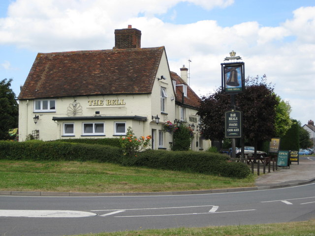
The village has two public houses and a social club, Westoning Recreation Club (situated at the recreation ground on Greenfield Road). The pubs are The Chequers, a half-timber and thatch building of 18th-century date, and The Bell, an 18th-century brick and tile house that had its sign displayed from an old oak standing by the roadside. On Park Road and Greenfield Road respectively. At the top of Sampshill Road, Billington's Car Company have their storage area for stock. Flitvale Garden Centre is located just within the boundary on the road to Flitwick.
The recreational facilities include Westoning Football Club, Westoning Tennis Club and the club holds a regular village tournament between its members.
Westoning Village Hall is situated in Church Road and stages regular productions by the village's amateur dramatic society, the Westoning Players. The building dates back to the 1840s and has a long and colourful history of village life. The village hall also runs a pre-school service.
From the Wikipedia article Westoning, under CC BY-SA 4.0.
Notable people from Westoning
- Steve LinsdellBritish motorcycle racer
Born in Westoning, according to Wikidata (CC0). Each name links to its Wikipedia article.
Where to stay1
Churches and places of worship13
Church of Saint Mary the Virgin, Harlington, Bedfordshire
Church · 1.2 mi
Shopping1
Gas and EV charging1
Schools, colleges and libraries6
Healthcare1
Map of Westoning
53 places. The map loads OpenStreetMap tiles when you open it.
Getting there and nearby towns
London Luton Airport (LTN) is the nearest airport with scheduled flights listed in OpenStreetMap, 9 miles away.
- Flitwick 2 mi north, about 2 min by car
- Greenfield 2 mi northeast, about 3 min by car
- Ampthill 3 mi north, about 5 min by car
- Silsoe 4 mi northeast, about 6 min by car
- Lidlington 5 mi northwest, about 8 min by car
- Houghton Conquest 6 mi north, about 9 min by car
- Shillington 6 mi east, about 9 min by car
- Stewartby 6 mi north, about 10 min by car
- Dunstable 7 mi south, about 11 min by car
- Luton 8 mi southeast, about 13 min by car
Drive times are estimates from straight-line distance, not routes.
Towns near Westoning


Keep exploring
Local news
Headlines from INDB.
Reviews, tips and questions
Loading what members have shared...
Sources and licences
- GeoNames (CC BY 4.0): population, coordinates, regions and time zone
- Mapillary (see each image): photos
- OpenStreetMap contributors (ODbL 1.0): places, airports, map data
- Wikidata (CC0 1.0): elevation, founding date, time zone, website, landmarks and historic places
- Wikimedia Commons (see each image): photos
- Wikipedia (CC BY-SA 4.0): overview and history text
Photo credits
- Bell-Westoning, Nigel Cox, CC BY-SA 2.0
- De Grey M, Tatraplan at English Wikipedia, Public domain
- Ruxox Farm moated site 15, Simon Burchell, CC BY-SA 4.0
- Cows in Fancott Woods and Meadows, Dudley Miles, CC BY-SA 4.0
- River Flit in Flitwick Moor 3, Dudley Miles, CC BY-SA 4.0
- St Marys C of E Church Harlington, Alex, CC BY-SA 4.0
- Street-level photo, zymurgic, CC BY-SA 4.0
- Street-level photo, ris, CC BY-SA 4.0
- Street-level photo, sk53, CC BY-SA 4.0
- Street-level photo, ris, CC BY-SA 4.0
- Street-level photo, ris, CC BY-SA 4.0
- Street-level photo, Lapscle, CC BY-SA 4.0
- Street-level photo, ris, CC BY-SA 4.0
- Street-level photo, ris, CC BY-SA 4.0
Page built November 10, 2026. Spotted a mistake? Tell us or suggest a place.