


Why visit Cheruthazham
Townapedia lists 8 parks and trails, 20 places to eat, 6 places to stay and 2 attractions in and around town.
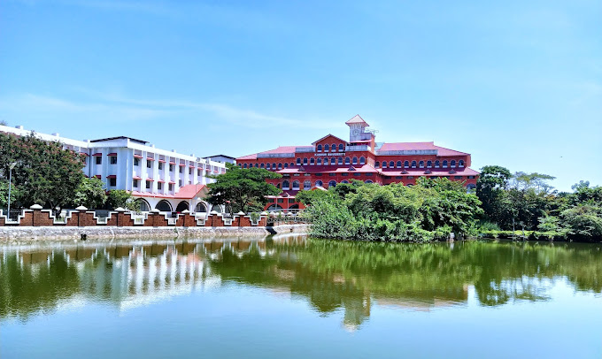
Highlights include Kannur University.
Weather in Cheruthazham
Forecast from MET Norway (CC BY 4.0). Full forecast
Things to do2
Kannur University
School · 3.9 km
State public university in Kannur, Kerala, India

Parks, trails and playgrounds8



Restaurants and cafes20



8 more on the map.
Where to stay6

Churches and places of worship30
Masjidu Rahma,Chumaduthangi
Place of worship · 1.2 km
Pilathara - Pazhayangadi - Pappinisseri Road
Shopping18
Gas and EV charging4
Schools, colleges and libraries34
Krishna pilla smaraka vayanashala, Periyat
Library · 1.3 km
Periyat, Cheruthazham
Payyaratta Raman smaraka mandiram, Periyat
Library · 0.7 km
Periyattambalam Road, cheruthazham
Healthcare9
Homeo Clinic
Clinic and pharmacy · 1.3 km
Pilathara - Pazhayangadi - Pappinisseri Road
Vachana jyothi De addiction center
Clinic and pharmacy · 0.7 km
Kasargod-Kannur-Calicut Highway
Vaidyanilayam, Pilathara
Hospital · 0.6 km
Pilathara - Mathamangalam, Cheruthazahm
Map of Cheruthazham
131 places. The map loads OpenStreetMap tiles when you open it.
Getting there and nearby towns
Kannur International Airport (CNN) is the nearest airport with scheduled flights listed in OpenStreetMap, 36 km away.
- Taliparamba 11 km southeast, about 11 min by car
- Pāppinisshēri 16 km southeast, about 16 min by car
- Nīlēshwar 24 km northwest, about 24 min by car
- Kannur 26 km southeast, about 26 min by car
- Kanhangad 30 km northwest, about 30 min by car
- Thottada 32 km southeast, about 32 min by car
- Irikkūr 33 km east, about 33 min by car
- Mattanur 38 km southeast, about 38 min by car
- Muluppilagadu 38 km southeast, about 38 min by car
- Dharmadam 40 km southeast, about 40 min by car
Drive times are estimates from straight-line distance, not routes.
Local news
Headlines from INDB.
Reviews, tips and questions
Loading what members have shared...
Sources and licences
- GeoNames (CC BY 4.0): population, coordinates, regions and time zone
- OpenStreetMap contributors (ODbL 1.0): places, airports, map data
- Wikidata (CC0 1.0): elevation, founding date, time zone, website, landmarks and historic places
- Wikimedia Commons (see each image): photos
Photo credits
- Kannur Univerisity Thavakkara Campus, Rahul B Ashok, CC0
- Govt Central UP School Kunhimangalam, Vijayanrajapuram, CC BY-SA 3.0
- Papilio demoleus at ezhilod, Nativeplants garden, CC BY-SA 4.0
- September Flowers at Aduppoottipara 20230929 151724 07, Deepa Chandran2014, CC BY-SA 4.0
- September Flowers at Aduppoottipara 20230929 151724 06, Deepa Chandran2014, CC BY-SA 4.0
- September Flowers at Aduppoottipara 20230929 151724 08, Deepa Chandran2014, CC BY-SA 4.0
- Historical reunion of Ezhilod, Aduppoottipara 2, Nativeplants garden, CC BY-SA 4.0
- September Flowers at Aduppoottipara 20230929 151724 09, Deepa Chandran2014, CC BY-SA 4.0
- September Flowers at Aduppoottipara 20230929 151724 10, Deepa Chandran2014, CC BY-SA 4.0
- September Flowers at Aduppoottipara 20230929 151724 02, Deepa Chandran2014, CC BY-SA 4.0
- September Flowers at Aduppoottipara 20230929 151724 03, Deepa Chandran2014, CC BY-SA 4.0
- September Flowers at Aduppoottipara 20230929 151724 05, Deepa Chandran2014, CC BY-SA 4.0
- Hyptis Flowers at Aduppoottipara 20230929 151724 04, Deepa Chandran2014, CC BY-SA 4.0
- Palott Kavu, Kunhimangalam (4601223552), Shareef Taliparamba, CC BY-SA 2.0
- Aduppootti Para @,Ezhilode 02, Sindhu Haridas, CC BY-SA 4.0
- Historical reunion of Ezhilod, Aduppoottipara, Nativeplants garden, CC BY-SA 4.0
- September Flowers at Aduppoottipara 20230929 151724 01, Deepa Chandran2014, CC BY-SA 4.0
- Aduppootti Para @,Ezhilode 01, Sindhu Haridas, CC BY-SA 4.0
- അടുപ്പൂട്ടിപ്പാറ, George Muttathil Pulikurumba, CC BY-SA 4.0
- Genus Clerodendrum, George Muttathil Pulikurumba, CC BY-SA 4.0
- Nerium oleander 4, George Muttathil Pulikurumba, CC BY-SA 4.0
- Evolvulus alsinoides 3, George Muttathil Pulikurumba, CC BY-SA 4.0
- Eclipta prostrata 2, George Muttathil Pulikurumba, CC BY-SA 4.0
- Chrysopogon zizanioides, George Muttathil Pulikurumba, CC BY-SA 4.0
- Nerium oleander 5, George Muttathil Pulikurumba, CC BY-SA 4.0
- കച്ചോലം @ കുഞ്ഞിമംഗലം IMG 20240710 093113, Sindhu Haridas, CC BY-SA 4.0
- Muntingia calabura L., George Muttathil Pulikurumba, CC BY-SA 4.0
- Flower at Madayipara 20230924 104832 10, Deepa Chandran2014, CC BY-SA 4.0


Page built November 3, 2026. Spotted a mistake? Tell us or suggest a place.