


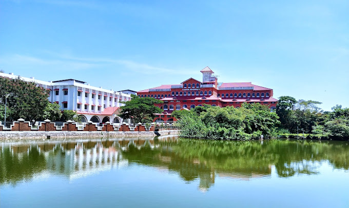


Why visit Nīlēshwar
Townapedia lists 4 museums and landmarks, 17 parks and trails, 14 places to eat, 1 place to stay and 2 attractions in and around town.
Highlights include Kannur University.
Weather in Nīlēshwar
Forecast from MET Norway (CC BY 4.0). Full forecast
About Nīlēshwar
Nileshwaram or Nileshwar or Neeleshwaram is a municipality and a major town in Kasaragod District, state of Kerala, India. It is one of the three municipalities in Kasaragod district; the others are Kasaragod and Kanhangad. Nileshwaram is located on the estuary of Kavvayi Backwaters and Neeleshwaram River. Nileshwaram is referred to as the cultural capital of Kasaragod, the northernmost district of Kerala.
From the Wikipedia article Nileshwaram (this version), under CC BY-SA 4.0.
Travel tips from other travellers: Nīlēshwar on Wikivoyage (CC BY-SA 4.0).
Things to do2
Kannur University
School · 3.8 km
State public university in Kannur, Kerala, India

Museums and landmarks4

Parks, trails and playgrounds17

C H Muhammed Koya Smaraka Government Vocational Higher Secondary School Kottapuram
Playground · 2.3 km



5 more on the map.
Restaurants and cafes14

Safe Cafe Restaurant
Restaurant · Regional · 1.5 km
Kasargod-Kannur-Calicut Highway, NILESHWAR




2 more on the map.
History
Neeleswaram, or Nileswaram, is the abbreviated form of Neelakanteshweram. The Kolathiri Dominion emerged into independent 10 principalities in the late medieval period, i.e., Kadathanadu (Vadakara), Randathara or Poyanad (Dharmadom), Kottayam (Thalassery), Nileshwaram, Iruvazhinadu (Panoor), Kurumbranad etc., under separate royal chieftains due to the outcome of internal dissensions. Many portions of the present-day Hosdurg taluk (Kanhangad) and Vellarikundu were parts of the Nileshwaram dynasty, who were relatives to both Kolathunadu as well as Zamorin of Calicut, in the early medieval period. Nileshwaram was historically the seat of the Neeleswaram Rajahs, who belonged to the clans of the Kolathiri and Zamorins. The Nileshwar Rajahs and the Bednore Nayaks battled in this area.
The grand finale of the annual temple festival season takes place in this area, which is known for its "kavus", or sacred groves. The most famous of the sacred groves is the Mannampurathu Kavu. The town is also known for Theyyam, the ritualistic art forms. Also Nileshwar is the first town in Kerala famous for cultivating 'Chengthengu' (red dwarf coconut).
From the History section of Nileshwaram on Wikipedia, under CC BY-SA 4.0.
Where to stay1
Grand View Residency
Motel and hotel · 0.8 km
Main bazar Nileshwar , Near Krishibhavan, Nileshwar , Kasargod dst.
Churches and places of worship33
Kottam Sri Vettaikkorumakan Temple
Place of worship · 0.9 km
Padinhattam Kozhuval
shree kazhakam bakavathi kshethram
Place of worship · 4.6 km
Cheruvathur-Achanthuruthu
Ankakkalari Vettakkorumakan Kottaram Padarkulangara Bhagavathi Temple
Place of worship · 3.2 km
Shopping2
Gas and EV charging2
Schools, colleges and libraries72
Government Higher Secondary School, Kakkat
School · 2.9 km
Neeleswaram-Chayyoth-Arayi
Roulathul Uloom English Medium High School Thuruthi
School · 4.7 km
Cheruvathur-Achanthuruthu
Healthcare12
Government Ayurveda Hospital
Hospital · 4.1 km
Checkpost Mundakandam Road, cheruvathur
Thejaswini Co-Operative Hospital & Medical Research Center Ltd.
Hospital · 1.6 km
Map of Nīlēshwar
159 places. The map loads OpenStreetMap tiles when you open it.
Getting there and nearby towns
Kannur International Airport (CNN) is the nearest airport with scheduled flights listed in OpenStreetMap, 59 km away.
- Perole 1 km southeast, about 1 min by car
- Kanhangad 6 km northwest, about 6 min by car
- Pilikōdu 8 km southeast, about 8 min by car
- Ajānūr 10 km northwest, about 10 min by car
- Taliparamba 34 km southeast, about 34 min by car
- Pāppinisshēri 40 km southeast, about 40 min by car
- Irikkūr 54 km southeast, about 54 min by car
- Tellicherry 69 km southeast, about 1 h 15 min by car
- Panoor 74 km southeast, about 1 h 15 min by car
- Mangaluru 79 km north, about 1 h 15 min by car
Drive times are estimates from straight-line distance, not routes.
Local news
Headlines from INDB.
Reviews, tips and questions
Loading what members have shared...
Sources and licences
- GeoNames (CC BY 4.0): population, coordinates, regions and time zone
- OpenStreetMap contributors (ODbL 1.0): places, airports, map data
- Wikidata (CC0 1.0): elevation, founding date, time zone, website, landmarks and historic places
- Wikimedia Commons (see each image): photos
- Wikipedia (CC BY-SA 4.0): overview and history text
Photo credits
- NAS College Kanhangad, Padannakkad, ranjithsiji, CC BY-SA 4.0
- Kannur Univerisity Thavakkara Campus, Rahul B Ashok, CC0
- Rajahs High School Nileshwar, Ajeeshkumar4u, CC BY-SA 4.0
- Nileshwar palace building -May 2023, Ajeeshkumar4u, CC BY-SA 4.0
- Sree mannanpurathukav, nileshwar 2024, Ajeeshkumar4u, CC BY-SA 4.0
- Sree mannanpurathukav, nileshwar 2024 2, Ajeeshkumar4u, CC BY-SA 4.0
- Mannampurathu kavu 08, Vijayanrajapuram, CC BY-SA 4.0
- Mannampurathu kavu 04, Vijayanrajapuram, CC BY-SA 4.0
- Mannampurathu kavu 01, Vijayanrajapuram, CC BY-SA 4.0
- Mannampurathu kavu 07, Vijayanrajapuram, CC BY-SA 4.0
- Mannampurathu kavu 03, Vijayanrajapuram, CC BY-SA 4.0
- Mannampurathu kavu 06, Vijayanrajapuram, CC BY-SA 4.0
- Mannampurathu kavu 05, Vijayanrajapuram, CC BY-SA 4.0
- Mannampurathu kavu 02, Vijayanrajapuram, CC BY-SA 4.0
- Sree mannanpurathukav, nileshwar 2024 3, Ajeeshkumar4u, CC BY-SA 4.0
- Sree mannanpurathukav, nileshwar 2024 4, Ajeeshkumar4u, CC BY-SA 4.0
- Soman Annur, Vijayanrajapuram, CC BY-SA 4.0
- Mariyattam3, Vijayanrajapuram, CC BY-SA 4.0
- Bhaskaran Annur, Vijayanrajapuram, CC BY-SA 4.0
- Kannur to Udupi views from train - vrvbsatara102k23pxl (111), Vinayaraj, CC BY-SA 4.0
- Kannur to Udupi views from train - vrvbsatara102k23pxl (113), Vinayaraj, CC BY-SA 4.0
- Kannur to Udupi views from train - vrvbsatara102k23pxl (114), Vinayaraj, CC BY-SA 4.0
- Kannur to Udupi views from train - vrvbsatara102k23pxl (117), Vinayaraj, CC BY-SA 4.0
- Kannur to Udupi views from train - vrvbsatara102k23pxl (109), Vinayaraj, CC BY-SA 4.0
- Kannur to Udupi views from train - vrvbsatara102k23pxl (108), Vinayaraj, CC BY-SA 4.0
- Kannur to Udupi views from train - vrvbsatara102k23pxl (115), Vinayaraj, CC BY-SA 4.0
- Kannur to Udupi views from train - vrvbsatara102k23pxl (105), Vinayaraj, CC BY-SA 4.0
- Kannur to Udupi views from train - vrvbsatara102k23pxl (106), Vinayaraj, CC BY-SA 4.0
- Kannur to Udupi views from train - vrvbsatara102k23pxl (112), Vinayaraj, CC BY-SA 4.0
- Kannur to Udupi views from train - vrvbsatara102k23pxl (110), Vinayaraj, CC BY-SA 4.0
- Kannur to Udupi views from train - vrvbsatara102k23pxl (116), Vinayaraj, CC BY-SA 4.0
- Kannur to Udupi views from train - vrvbsatara102k23pxl (107), Vinayaraj, CC BY-SA 4.0
- Soman Annur Kurathiyattam, Vijayanrajapuram, CC BY-SA 4.0
- Rajahs High School Nileshwar (28121), Ajeeshkumar4u, CC BY-SA 4.0
- Mariyattam1, Vijayanrajapuram, CC BY-SA 4.0
- Kannur to Udupi views from train - vrvbsatara102k23pxl (118), Vinayaraj, CC BY-SA 4.0
- Kannur to Udupi views from train - vrvbsatara102k23pxl (104), Vinayaraj, CC BY-SA 4.0
- Kannur to Udupi views from train - vrvbsatara102k23pxl (101), Vinayaraj, CC BY-SA 4.0
- Kannur to Udupi views from train - vrvbsatara102k23pxl (98), Vinayaraj, CC BY-SA 4.0
- Kannur to Udupi views from train - vrvbsatara102k23pxl (100), Vinayaraj, CC BY-SA 4.0


Page built November 3, 2026. Spotted a mistake? Tell us or suggest a place.