



Why visit Kāsaragod
Townapedia lists 3 museums and landmarks, 15 parks and trails, 135 places to eat, 41 places to stay and 7 attractions in and around town.
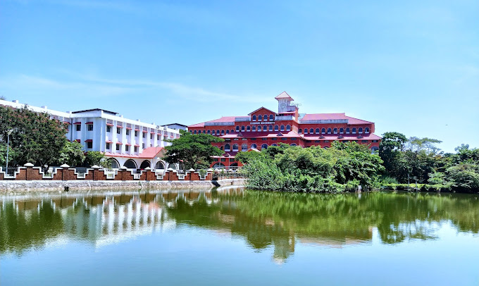
Highlights include Kannur University, Kasaragod Lighthouse, Chandragiri fort and SEA VIEW PARK.
Weather in Kāsaragod
Forecast from MET Norway (CC BY 4.0). Full forecast
About Kāsaragod
Kasaragod (Malayalam: [kaːsɐrɐɡoːɖɨ̆] ) is a municipal town and the administrative headquarters of the Kasaragod district in the state of Kerala, India. Established in 1966, Kasaragod was the first municipal town in the district. It is the northernmost district of Kerala and is also known as Sapta Bhasha Sangama Bhumi ('The Land of Seven Languages').
From the Wikipedia article Kasaragod (this version), under CC BY-SA 4.0.
Travel tips from other travellers: Kāsaragod on Wikivoyage (CC BY-SA 4.0).
Things to do7
Kannur University
School · 3.2 km
State public university in Kannur, Kerala, India



Museums and landmarks3

Parks, trails and playgrounds15


SEA VIEW PARK
Park · 0.7 km
OLD RAILWAY STATION ROAD THAYLANGADI KASARAGOD THAYALANGADI, Kasargod
Mo-Su 09:00-19:00

Kasaragod Muncipal Stadium
Sports field and stadium · 4.0 km
Madhur -Vidyanagara - Kasaragod Road, Kasargod

POYKARA ABDURAHMAN HAJI PARK
Park · 0.8 km
RAILWAY STATION ROAD THAYLANGADI KASARAGOD Railway Station Road, Kasaragod

3 more on the map.
Restaurants and cafes135

Golden Bakery
Restaurant · Burger, Coffee Shop, Chicken, American, Sandwich, Indian, Seafood, Kebab, Ice Cream, Pizza, Barbecue, Juice, Chocolate · 3.7 km
Kasaragod - Kanhangad state highway, melparamba
Mo-Su 09:00-23:00
AFC
Restaurant · Burger, Fries, Fried Chicken, Fried Food · 4.0 km
Mo-Su 03:00-23:00
Parche Cafe
Restaurant · Chicken, Chinese, Coffee Shop, Deli, Diner, Local, Noodles · 0.9 km
Mo-Su 12:30-00:00


COCHIN BAKERY
Bakery · 2.3 km
Kasargod-Kannur-Calicut Highway, Kasargod
HOTEL KAVERI
Restaurant · 3.7 km
industrial estate road, vidyanagar
HOTEL LIFE LINE
Restaurant · 3.6 km
industrial estate road, vidyanagar
123 more on the map.
Where to stay41
GIRLS HOSTEL
Motel and hotel · 1.6 km
Malik deenar nagar thalangara kasargod pin 671122 Railway Station Road, Kasargod
HOTEL TAJ RECEPTION
Motel and hotel · 1.2 km
Kasargod-Kannur-Calicut Highway, Kasaragod
railway quarters
Motel and hotel · 0.8 km
OLD RAILWAY STATION ROAD THAYLANGADI KASARAGOD old Railway Station Road, KASARAGOD
Churches and places of worship59
Shivamangalam Sadashiva Temple
Place of worship · 3.7 km
Gopalakrishna Temple road, kasaragod
HYDROS JUMA MASJID
Place of worship · 0.7 km
Pallam - Nellikkunnu - Kadappuram Road, Kasargod
Shopping55
BHARATH MACHINE TOOLS
Hardware store · 1.2 km
Kasargod-Kannur-Calicut Highway, Kasaragod
NAVA BHARATH MACHINE TOOLS
Hardware store · 1.3 km
Kasargod-Kannur-Calicut Highway, Kasaragod
Gas and EV charging8
Schools, colleges and libraries53
Sri Gopalakrishna High School Kudlu
School · 2.9 km
Madhur -Kasaragod Road, kudlu
Government Lower Primary School Kudlu
School · 2.3 km
GLPS Kudlu Madhur -Kasaragod Road, Meepuguri
Healthcare72
APPLE DENTAL CLINIC
Clinic and pharmacy · 1.2 km
Kasargod-Kannur-Calicut Highway, Kasaragod
Ayurvedic Government hospital
Clinic and pharmacy · 3.0 km
Madhur -Kasaragod Road, KUDLU, KASARAGOD
BHATS CLINIC AND LABORAORY
Clinic and pharmacy · 1.3 km
Kasargod-Kannur-Calicut Highway, Kasaragod
Darul Hijama
Clinic and pharmacy
fish market,fort road Railway Station Road, Kasaragod
Map of Kāsaragod
250 places. The map loads OpenStreetMap tiles when you open it.
Getting there and nearby towns
Mangalore International Airport (IXE) is the nearest airport with scheduled flights listed in OpenStreetMap, 52 km away.
- Chammanād 3 km southeast, about 3 min by car
- Kūdlu 4 km north, about 4 min by car
- Madhūru 5 km northeast, about 5 min by car
- Kanhangad 25 km southeast, about 25 min by car
- Nīlēshwar 31 km southeast, about 31 min by car
- Mangaluru 49 km north, about 49 min by car
- Taliparamba 65 km southeast, about 1 h by car
- Pāppinisshēri 71 km southeast, about 1 h 15 min by car
- Irikkūr 83 km southeast, about 1 h 30 min by car
- Mattanur 89 km southeast, about 1 h 30 min by car
Drive times are estimates from straight-line distance, not routes.
Local news
Headlines from INDB.
Reviews, tips and questions
Loading what members have shared...
Sources and licences
- GeoNames (CC BY 4.0): population, coordinates, regions and time zone
- OpenStreetMap contributors (ODbL 1.0): places, airports, map data
- Wikidata (CC0 1.0): elevation, founding date, time zone, website, landmarks and historic places
- Wikimedia Commons (see each image): photos
- Wikipedia (CC BY-SA 4.0): overview and history text
Photo credits
- Kasaragod town view, ARUNKUMAR P.R, CC BY-SA 3.0
- Chandragiri Fort, Kerala, Hafeezkv, CC BY-SA 4.0
- Government college kasaragod 03, Vijayanrajapuram, CC BY-SA 4.0
- Kasargod Light 03, Dr. Ajay Balachandran, CC BY-SA 4.0
- Kannur Univerisity Thavakkara Campus, Rahul B Ashok, CC0
- Chandrigiri Fort -Kasaragod -Kerala -file 1001, Maqsood Poovadka, CC BY-SA 4.0
- Kite fest at Bekal Pallikkara Beach of Kasaragod dist 13, Vijayanrajapuram, CC BY-SA 4.0
- Cartoon P V krishnan 01, Vijayanrajapuram, CC BY-SA 4.0
- Mallikarjuna Temple Kasaragod 02, Vijayanrajapuram, CC BY-SA 4.0
- Mallikarjuna Temple Kasaragod 05, Vijayanrajapuram, CC BY-SA 4.0
- Mallikarjuna Temple Kasaragod 04, Vijayanrajapuram, CC BY-SA 4.0
- Mallikarjuna Temple Kasaragod 03, Vijayanrajapuram, CC BY-SA 4.0
- Mallikarjuna Temple Kasaragod 01, Vijayanrajapuram, CC BY-SA 4.0
- Pookkalam@ bemhs.kasaragod 02, Roshniprakashk, CC BY-SA 4.0
- Pookkalam@ bemhs.kasaragod 01, Roshniprakashk, CC BY-SA 4.0
- Thayalangadi Temple Kasaragod, Prof tpms, CC BY-SA 4.0
- Wind seed dispresal, Vijayanrajapuram, CC BY-SA 4.0
- Kasaragod-ksrtc-bus-stand, rajeshodayanchal, CC BY 3.0
- Coconut palm art2, Vijayanrajapuram, CC BY-SA 4.0
- 11473 AUPSMADONAKASARAGOD ENTRANCE, Midhunnileshwar, CC BY-SA 4.0
- V.V.Temple Thayalangadi, Prof tpms, CC0
- 11473 AUPSMADONAKASARAGOD ARTWORK 02, Midhunnileshwar, CC BY-SA 4.0
- 11473 AUPSMADONAKASARAGOD PLAYGROUND, Midhunnileshwar, CC BY-SA 4.0
- P V krishnan Cartoonist, Vijayanrajapuram, CC BY-SA 4.0
- 11473 AUPSMADONAKASARAGOD SCHOOLBUILDING 04, Midhunnileshwar, CC BY-SA 4.0
- 11473 AUPSMADONAKASARAGOD SCHOOLBUILDING 07, Midhunnileshwar, CC BY-SA 4.0
- 11473 AUPSMADONAKASARAGOD SCHOOLBUILDING 03, Midhunnileshwar, CC BY-SA 4.0
- Madonna Convent area in Thayalangadi (1), Prof tpms, CC0
- 11473 AUPSMADONAKASARAGOD SCHOOLBUILDING 02, Midhunnileshwar, CC BY-SA 4.0
- 11473 AUPSMADONAKASARAGOD SCHOOLBUILDING 01, Midhunnileshwar, CC BY-SA 4.0
- Chillis Supermarket Kasaragod, Prof tpms, CC0
- Madonna Convent area in Thayalangadi (2), Prof tpms, CC0
- Restaurants near Kasaragod Railway Station (2), Prof tpms, CC0
- Kasaragod Railway station, Manukrishnan80, CC BY-SA 3.0
- Restaurants near Kasaragod Railway Station (1), Prof tpms, CC0
- Open Air Auditorium at Pulikkunnu, Prof tpms, CC BY-SA 4.0
- Sea View park Kasaragod, Prof tpms, CC BY-SA 4.0
- Seaview park Kasaragod RS, Prof tpms, CC BY-SA 4.0
- Kasaragod Railway Station (4601247110), Shareef Taliparamba, CC BY-SA 2.0
- Kasaragod Railway Station 2026 (1), Prof tpms, CC0
- Sea View Park, Kasaragod. (4635013584), Shareef Taliparamba, CC BY-SA 2.0


Page built November 3, 2026. Spotted a mistake? Tell us or suggest a place.