


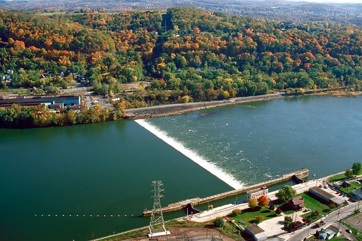


Tarentum, Pennsylvania
Tarentum is a borough of 4,249 people in Allegheny County, Pennsylvania, founded in March 7, 1842.
Why visit Tarentum
Townapedia lists 6 museums and landmarks, 3 parks and trails, 17 places to eat, 1 place to stay and 2 attractions in and around town.
Highlights include C. L. Schmitt Bridge, George D. Stuart Bridge, Allegheny River Lock and Dam No. 4 and Burtner House.
July is the warmest month, with average highs of 83°F; January lows average 20°F.
Weather in Tarentum
Forecast from the National Weather Service. Full forecast
About Tarentum
Tarentum is a borough in Allegheny County, Pennsylvania, approximately 22 miles northeast of Pittsburgh, located along the Allegheny River. Incorporated in 1842 and founded by Henry Brackenridge, the borough historically served as an industrial center for glass, paper, steel, and brick manufacturing. The borough is connected to New Kensington via the George D. Stuart Bridge and is served by the Highlands School District.
From the Wikipedia article Tarentum, Pennsylvania (this version), under CC BY-SA 4.0.
Things to do2

C. L. Schmitt Bridge
Bridge · 3.0 mi
Bridge in Pennsylvania, United States

George D. Stuart Bridge
Bridge · 0.8 mi
Bridge over the Allegheny River in Pennsylvania
Museums and landmarks6
Allegheny River Lock and Dam No. 4
Monument and historic site · National Register of Historic Places · 2.3 mi
Gravity dam and lock in Harrison Township, Pennsylvania

Burtner House
Monument and historic site · National Register of Historic Places · 2.3 mi
Historic house in Pennsylvania, United States


New Kensington Downtown Historic District
Monument and historic site · National Register of Historic Places · 2.9 mi
Historic district in New Kensington, Pennsylvania
New Kensington Production Works Historic District
Monument and historic site · National Register of Historic Places · 2.9 mi
Historic district in Pennsylvania, United States
Pennsalt Historic District
Monument and historic site · National Register of Historic Places · 2.1 mi
Historic district in Pennsylvania, United States
Parks, trails and playgrounds3


Restaurants and cafes17

Maddio's Pizza and Subs
Restaurant · Pizza, Sandwich · 1.0 mi
1000 Broadview Boulevard, Brackenridge
Mo-We 11:00-21:00, Th-Sa 11:00-23:00; Su 12:00-21:00





5 more on the map.
History
In the 1750s a Shawnee trader named Peter Chartier had briefly operated a trading post in this area.
The area that would become Tarentum was first settled in 1796 and formally laid out in 1829 by Henry Marie Brackenridge, son of Pittsburgh pioneer Hugh Henry Brackenridge. The borough was incorporated on March 7, 1842.
During the nineteenth and early twentieth centuries, Tarentum developed as an industrial hub along the Allegheny River. Local manufacturers produced plate glass, bottles, bricks, steel, lumber, and paper, and the surrounding hills were mined for coal and iron ore. The borough’s location on the Pennsylvania Railroad and later streetcar lines supported its growth as a working-class river community.
By the early twentieth century, Tarentum was home to several thousand residents and a mix of immigrant communities who came to work in the mills and factories. Industrial decline in the latter half of the century led to population loss and economic transition, but the borough has continued to serve as a residential and commercial center for the Alle-Kiski Valley.
From the History section of Tarentum, Pennsylvania on Wikipedia, under CC BY-SA 4.0.
Where to stay1
Churches and places of worship12
Mount St. Peter Church
Church · National Register of Historic Places · 3.1 mi
Shopping5
Gas and EV charging4
Schools, colleges and libraries25
Healthcare2
Map of Tarentum
77 places. The map loads OpenStreetMap tiles when you open it.
Climate by month
Monthly table
| Month | High | Low | Rain |
|---|---|---|---|
| Jan | 36°F | 20°F | 3.1 in |
| Feb | 40°F | 21°F | 2.8 in |
| Mar | 50°F | 27°F | 3.3 in |
| Apr | 62°F | 38°F | 3.6 in |
| May | 72°F | 50°F | 3.9 in |
| Jun | 80°F | 59°F | 4.3 in |
| Jul | 83°F | 63°F | 4.3 in |
| Aug | 82°F | 62°F | 3.5 in |
| Sep | 76°F | 55°F | 4.0 in |
| Oct | 64°F | 43°F | 3.1 in |
| Nov | 52°F | 33°F | 3.1 in |
| Dec | 41°F | 26°F | 3.3 in |
U.S. Climate Normals 1991-2020 for Natrona Lock 4 (2 mi away), NOAA NCEI.
People and cost of living
American Community Survey 5-year estimates, 2020-2024, U.S. Census Bureau. Estimates have margins of error, larger for small towns.
Disaster history
Allegheny County has had 8 federal disaster declarations since 2000, most often for hurricanes.
- 2020-03-30: Covid-19 Pandemic (Biological)
- 2020-03-13: Covid-19 (Biological)
- 2013-10-01: Severe Storms, Tornadoes, And Flooding (Severe Storm)
- 2012-10-29: Hurricane Sandy (Hurricane)
- 2010-04-16: Severe Winter Storms And Snowstorms (Snowstorm)
- 2005-09-10: Hurricane Katrina (Hurricane)
OpenFEMA disaster declarations summaries.
Getting there and nearby towns
Pittsburgh-Butler Regional Airport (BTP) is the nearest airport with scheduled flights listed in OpenStreetMap, 16 miles away.
- Brackenridge 1 mi east, about 2 min by car
- Arnold 2 mi south, about 3 min by car
- Natrona Heights 2 mi northeast, about 3 min by car
- New Kensington 2 mi south, about 4 min by car
- Lower Burrell 3 mi southeast, about 4 min by car
- Russellton 4 mi west, about 7 min by car
- Springdale 5 mi south, about 8 min by car
- Cheswick 5 mi southwest, about 8 min by car
- Plum 7 mi south, about 12 min by car
- Oakmont 7 mi southwest, about 12 min by car
Drive times are estimates from straight-line distance, not routes.
Local news
Headlines from INDB, the NEMICO news database.
Reviews, tips and questions
Loading what members have shared...
Sources and licences
- NCES EDGE (Public domain): public schools
- NOAA NCEI U.S. Climate Normals 1991-2020 (Public domain): climate by month
- OpenFEMA (Public domain): disaster declarations
- OpenStreetMap contributors (ODbL 1.0): places, airports, map data
- U.S. Census Bureau (Public domain): population, income, housing, education, commute
- Wikidata (CC0 1.0): elevation, founding date, time zone, website, landmarks and historic places
- Wikimedia Commons (see each image): photos
- Wikipedia (CC BY-SA 4.0): overview and history text
Photo credits
- Tarentum from 366 Bridge, Nyttend, Public domain
- Mount Saint Peter Church, Rudy4rachel ( talk ), Public domain
- Allegheny River Lock and Dam No.4, U.S. Army Corps of Engineers, Public domain
- Liberty Theater, New Kensington, Fred S. Danner, Public domain
- Tarentumbridge, Mr. Vitale ( talk ), Public domain
Page built October 30, 2026. Spotted a mistake? Tell us or suggest a place.