


Why visit Ulubey
Townapedia lists 1 museum or landmark, 1 park or trail, 2 places to eat and 6 attractions in and around town.
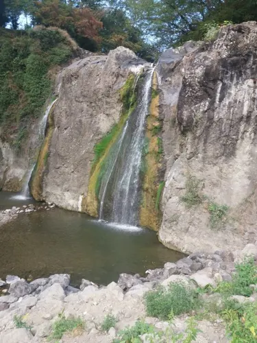
Highlights include Ohtamış Waterfall, Çal Tepesi and Ordu Ethnographical Museum.
Weather in Ulubey
Forecast from MET Norway (CC BY 4.0). Full forecast
About Ulubey
Ulubey is a municipality and district of Ordu Province, Turkey. Its area is 295 km2, and its population is 16,976 (2022). The town lies at an elevation of 602 m (1,975 ft).
From the Wikipedia article Ulubey, Ordu (this version), under CC BY-SA 4.0.
Things to do6




Museums and landmarks1

Parks, trails and playgrounds1

Restaurants and cafes2


Churches and places of worship5
Gas and EV charging1
Schools, colleges and libraries2
Healthcare7
Map of Ulubey
25 places. The map loads OpenStreetMap tiles when you open it.
Getting there and nearby towns
Ordu Giresun Havalimanı (OGU) is the nearest airport with scheduled flights listed in OpenStreetMap, 30 km away.
- Ordu 17 km northeast, about 17 min by car
- Perşembe 22 km north, about 22 min by car
- Fatsa 28 km northwest, about 28 min by car
- Bulancak 41 km east, about 41 min by car
- Ünye 49 km northwest, about 49 min by car
- Giresun 54 km east, about 54 min by car
- Niksar 74 km southwest, about 1 h 15 min by car
- Terme 76 km northwest, about 1 h 15 min by car
- Suşehri 84 km south, about 1 h 30 min by car
- Şebin Karahisar 86 km southeast, about 1 h 30 min by car
Drive times are estimates from straight-line distance, not routes.
Local news
Headlines from INDB.
Reviews, tips and questions
Loading what members have shared...
Sources and licences
- GeoNames (CC BY 4.0): population, coordinates, regions and time zone
- Mapillary (see each image): photos
- OpenStreetMap contributors (ODbL 1.0): places, airports, map data
- Wikidata (CC0 1.0): elevation, founding date, time zone, website, landmarks and historic places
- Wikimedia Commons (see each image): photos
- Wikipedia (CC BY-SA 4.0): overview and history text
Photo credits
- Abdan han yanı - panoramio, nami yildirim, CC BY 3.0
- Ulubey ordu, Denizgör, CC BY-SA 4.0
- 52850 Eymür-Ulubey-Ordu, Turkey - panoramio, nami yildirim, CC BY 3.0
- Ordu'nun güzelliği, Cemal satış, CC BY-SA 4.0
- Eymure dogru catalkaya - panoramio, nami yildirim, CC BY 3.0
- Yayladan gelen otlar karaağaç 52 k 1565 - panoramio, nami yildirim, CC BY 3.0
- Karaağaçtan çatalkaya pamukkaya - panoramio, nami yildirim, CC BY 3.0
- Ordu eymur - panoramio, nami yildirim, CC BY 3.0
- ISS065-E-417479 - View of Earth, Earth Science and Remote Sensing Unit , Lyndon B. Johnson Space Center, Public domain
- ISS061-E-140761 - View of Earth, Earth Science and Remote Sensing Unit, NASA Johnson Space Center, Public domain
- ISS061-E-140762 - View of Earth, Earth Science and Remote Sensing Unit, NASA Johnson Space Center, Public domain
- ISS023-E-6211 - View of Earth, Earth Science and Remote Sensing Unit , Lyndon B. Johnson Space Center, Public domain
- ISS023-E-6212 - View of Earth, Earth Science and Remote Sensing Unit , Lyndon B. Johnson Space Center, Public domain
- Abdan handaki eymür tabelası - panoramio, nami yildirim, CC BY 3.0
- Abdanhan handan katırcıoğluna giden yol - panoramio, nami yildirim, CC BY 3.0
- Melet kıyısında eymur - panoramio, nami yildirim, CC BY 3.0
- ISS061-E-140760 - View of Earth, Earth Science and Remote Sensing Unit, NASA Johnson Space Center, Public domain
- ISS065-E-417477 - View of Earth, Earth Science and Remote Sensing Unit , Lyndon B. Johnson Space Center, Public domain
- ISS061-E-140759 - View of Earth, Earth Science and Remote Sensing Unit, NASA Johnson Space Center, Public domain
- ISS034-E-12222 - View of Earth, Earth Science and Remote Sensing Unit , Lyndon B. Johnson Space Center, Public domain
- ISS065-E-417478 - View of Earth, Earth Science and Remote Sensing Unit , Lyndon B. Johnson Space Center, Public domain
- EYMUR den KARAAĞAÇ'a duman gelir - panoramio, nami yildirim, CC BY 3.0
- MELETE DUMAN ÇÖKTÜ - panoramio, nami yildirim, CC BY 3.0
- Ordu durak köyü, Denizgör, CC BY-SA 4.0
- Street-level photo, orducbs, CC BY-SA 4.0


Page built November 8, 2026. Spotted a mistake? Tell us or suggest a place.