
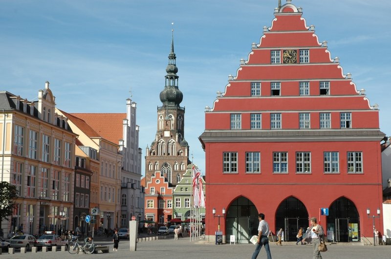


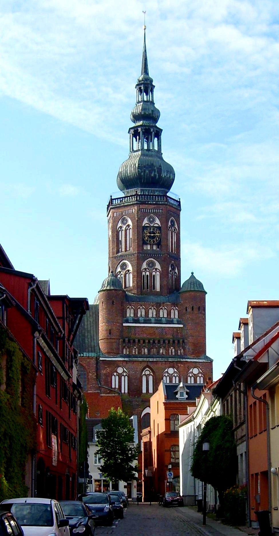


Universitäts- und Hansestadt Greifswald, Germany
Greifswald
Universitäts- und Hansestadt Greifswald is a town of 52,731 people in Mecklenburg-Vorpommern, Germany, founded in 1199.
Why visit Universitäts- und Hansestadt Greifswald
Townapedia lists 46 museums and landmarks, 29 parks and trails, 182 places to eat, 28 places to stay and 17 attractions in and around town.
Highlights include Wiecker Brücke, Dexter Hof Tammert, Pommersches Landesmuseum and Caspar-David-Friedrich-Zentrum.
Weather in Universitäts- und Hansestadt Greifswald
Forecast from MET Norway (CC BY 4.0). Full forecast
About Universitäts- und Hansestadt Greifswald
Greifswald (German pronunciation: [ˈɡʁaɪfsvalt] ; Low German: Griepswold), officially the University and Hanseatic City of Greifswald (German: Universitäts- und Hansestadt Greifswald) is the fourth-largest city in the German state of Mecklenburg-Western Pomerania after Rostock, Schwerin and Neubrandenburg. In 2021 it surpassed Stralsund for the first time, and became the largest city in the Pomeranian part of the state. It sits on the River Ryck, at its mouth into the Danish Wiek, a sub-bay of the Bay of Greifswald, which is itself a sub-bay of the Bay of Pomerania of the Baltic Sea.
From the Wikipedia article Greifswald (this version), under CC BY-SA 4.0.
Travel tips from other travellers: Universitäts- und Hansestadt Greifswald on Wikivoyage (CC BY-SA 4.0).
Photos of Universitäts- und Hansestadt Greifswald


Things to do17



Dexter Hof Tammert
Farm and orchard · 5.4 km
34 Feldstraße, Hinrichshagen
Tu,Th,Fr 15:00-20:00; Sa 09:00-12:00


5 more on the map.
Museums and landmarks46


Caspar-David-Friedrich-Zentrum
Museum · 1.8 km
57 Lange Straße, Greifswald
May-Sep Tu-Su 11:00-17:00; Oct-Apr Tu-Sa 11:00-17:00
Pomeranian State Museum
Museum · 1.4 km
Public museum primarily dedicated to Pomeranian history and arts


Fangenturm
Monument and historic site · 1.5 km
31 Hafenstraße, Greifswald


Museumshafen
Monument and historic site · 1.6 km
31 Hafenstraße, Greifswald


Studio Galerie Greifswald
Museum · 1.4 km
26a Kuhstraße, Greifswald
Tu-Fr 11:00-18:00; Sa 10:00-14:00
34 more on the map.
Parks, trails and playgrounds29



Freizeitbad Greifswald
Sports field and stadium · 1.0 km
3 Pappelallee, Greifswald
Mo 06:00-22:00; Tu-Sa 07:00-22:00; PH 08:00-21:00

Heimattierpark Greifswald
Park · 2.4 km
3 Anlagen, Greifswald
Nov-Mar: Mo-Su,PH 10:00-16:00; Apr-Oct: Mo-Su,PH 09:00-17:00;...
Botanischer Garten
Park · 2.4 km
2 Münterstraße
Mo-Fr 09:00-15:45; Dec-Feb PH,Sa,Su 13:00-15:00; Mar,Apr,Oct,Nov...

Volksstadion
Sports field and stadium · 0.8 km
2 Karl-Liebknecht-Ring

Marina am Ryck - Yachtzentrum Greifswald
Marina and boat launch · 1.4 km
17 more on the map.
Restaurants and cafes182
Fischer-Hütte
Restaurant · Fish, German · 3.1 km
12 An der Mühle, Greifswald
Mo-Fr 11:30-22:00; Sa-Su 11:00-22:00
Greifswalder Logenhaus
Restaurant · Regional · 1.3 km
3 Am Mühlentor, Greifswald
Mo-Th 08:00-22:30; Fr-Sa 08:00-00:00; PH,Su 09:00-22:30
Küche Am Gorzberg
Restaurant · Regional · 1.6 km
14 Am Gorzberg, Greifswald
Mo-Th 07:00-14:00; Fr 07:00-13:00; Sa,Su,PH off
L'Osteria
Restaurant · Italian · 1.1 km
108 Anklamer Straße, Greifswald
Mo-Sa 11:30-23:00; Su,PH 12:00-23:00

Café Küstenkind
Cafe · Cake, Breakfast, Coffee Shop · 1.8 km
69 Lange Straße, Greifswald
Th-Tu 10:00-18:00

O´Sole Mio
Restaurant · Pizza · 1.3 km
56a Ernst-Thälmann-Ring, Greifswald
Su-Fr 10:00-22:00; Sa,PH off
170 more on the map.
History
Greifswald was founded in 1199 when Cistercian monks founded the Eldena Abbey. In 1250, Wartislaw III, Duke of Pomerania, granted town privileges to Greifswald according to the Lübeck law.
In medieval times, the site of Greifswald was an unsettled woodland which marked the border between the Danish Principality of Rügen and the Pomeranian County of Gützkow, which at that time was also under Danish control. In 1199, the Rugian Prince Jaromar I allowed Danish Cistercian monks to build Hilda Abbey, now Eldena Abbey, at the mouth of the River Ryck. Among the lands granted the monks was a natural salt evaporation pond a short way up the river, a site also crossed by an important south–north via regia trade route. This site was named Gryp(he)swold(e), which is the Low German precursor of the city's modern name – which means "Griffin's Forest." Legend says the monks were shown the best site for settlement by a mighty griffin living in a tree that supposedly grew on what became Greifswald's oldest street, the Schuhagen. The town's construction followed a scheme of rectangular streets, with church and market sites reserved in central positions. It was settled primarily by Germans in the course of the Ostsiedlung, but settlers from other nations and Wends from nearby were attracted, too.
Read more of the history
The salt trade helped Eldena Abbey to become an influential religious center, and Greifswald became a widely known market. When the Danes had to surrender their Pomeranian lands south of the Ryck, after losing the Battle of Bornhöved in 1227, the town succeeded to the Pomeranian dukes. In 1241, the Rugian prince Wizlaw I and the Pomeranian duke Wartislaw III both granted Greifswald market rights. In 1250, the latter granted the town a charter under Lübeck law, after he had been permitted to acquire the town site as a fief from Eldena Abbey in 1248.
When Jazco of Salzwedel from Gützkow founded a Franciscan friary within the walls of Greifswald, the Cistercians at Eldena lost much of their influence on the city's further development. Just beyond Greifswald's western limits, a town-like suburb (Neustadt) arose, separated from Greifswald by a ditch. In 1264, Neustadt was incorporated and the ditch was filled in.
Eldena Abbey and the major buildings of Greifswald were erected in the North German Brick Gothic (Backsteingotik) style, found along the entire southern coast of the Baltic.
Due to a steady population increase, Greifswald became at the end of the 13th century one of the earliest members of the Hanseatic League, which further increased its trade and wealth. After 1296, Greifswald's citizens no longer needed to serve in the Pomeranian army, and Pomeranian dukes did not reside in the city.
In 1456, Greifswald's mayor Heinrich Rubenow laid the foundations of one of the oldest universities in the world, the University of Greifswald, which was one of the first in Germany, and was, successively, the single oldest in Sweden and Prussia.
In the course of Reformation, Eldena Abbey ceased to function as a monastery. Its possessions fell to the Pomeranian dukes; the bricks of its Gothic buildings were used by the locals for other construction. Eldena lost its separate status and was later absorbed into the town of Greifswald. The religious houses within the town walls, the priories of the Blackfriars (Dominicans) in the northwest and the Greyfriars (Franciscans) in the southeast, were secularized. The buildings of the Dominicans (the "black monastery") were turned over to the university; the site is still used as part of the medical campus. The Franciscan friary ("the "grey monastery") and its succeeding buildings are now the Pomeranian State Museum.
During the Thirty Years' War, Greifswald was occupied by (Catholic) Imperial forces from 1627 to 1631, and thereafter, under the Treaty of Stettin (1630), by (Protestant) Swedish forces.
During the Thirty Years' War, Swedish forces entered the Duchy of Pomerania in 1630. Greifswald was besieged by Swedish troops on 12 June 1631 and surrendered on 16 June. Gustavus Adolphus of Sweden had returned from Brandenburg to supervise the siege, and upon his arrival received the university's homage for the liberation from Catholic forces. After the Thirty Years' War (1618–1648), Greifswald and the region surrounding it became part of the Kingdom of Sweden. Swedish Pomerania, as it was then called, remained part of the Swedish kingdom until 1815, when it became part of the Kingdom of Prussia as the Province of Pomerania. In 1871, it devolved to Germany.
The Thirty Years' War had caused starvation throughout Germany, and by 1630 Greifswald's population had shrunk by two-thirds. Many buildings were left vacant and fell into decay. Soon, other wars followed: the Swedish-Polish War and the Swedish-Brandenburg War both involved the nominally Swedish town of Greifswald. In 1659 and 1678, Brandenburgian troops bombarded the town. The first bombardment hit mainly the northeast part of town, wrecking 16 houses. The second bombardment leveled 30 houses and damaged hundreds more all over the city. Cannonballs of this second bombardment can still be seen in the walls of St Mary's Church.
During the Great Northern War (1700–1721), Greifswald was compelled to house soldiers. While besieging neighboring Stralsund, Russian tsar Peter the Great allied with George I of Great Britain in the Treaty of Greifswald. Large fires in 1713 and 1736 destroyed houses and other buildings, including City Hall. The Swedish government had issued decrees in 1669 and 1689 absolving anyone of taxes who built or rebuilt a house. These decrees remained essentially in force, under Prussian administration, until 1824.
About 1900, the town – for the first time since the Middle Ages – expanded significantly beyond the old town walls. Also, a major railway connected Greifswald to Stralsund and Berlin; a local railway line further connected Greifswald to Wolgast.
From the History section of Greifswald on Wikipedia, under CC BY-SA 4.0.
More about Universitäts- und Hansestadt Greifswald
Geography
Greifswald is located in the northeast of Germany, approximately equidistant from Germany's two largest islands, Rügen and Usedom. The city is situated at the south end of the Bay of Greifswald, the historic centre being about five kilometres (three miles) up the river Ryck that crosses the city. The area around Greifswald is mainly flat, and hardly reaches more than 20 m above sea level. Two islands, Koos and Riems, are also part of Greifswald. Three of Germany's fourteen national parks can be reached by car in one hour or less from Greifswald.
Greifswald is also roughly equidistant from Germany's two largest cities, Berlin (240 km or 150 mi) and Hamburg (260 km or 160 mi). The nearest larger cities are Stralsund and Rostock.
The coastal part of Greifswald at the mouth of the Ryck, named Greifswald-Wieck, evolved from a fishing village. Today it provides a small beach, a marina and the main port for Greifswald.
Greifswald features an oceanic climate with some humid continental influence. Summers are pleasantly warm, although chilly at night. Due to its coastal location, heatwaves in Greifswald tend to be less extreme than other nearby locations inland. Winters are mild to cold, with occasional cold fronts coming in from Scandinavia or Siberia. Precipitation is spread throughout the year and comparatively low by German standards, while sunshine hours are above the German average.
Economy
Greifswald and Stralsund are the largest cities in the Vorpommern part of Mecklenburg-Vorpommern. Of great importance to the city's economy is the local university with its 12,000 students and nearly 5,000 employees in addition to many people employed at independent research facilities such as the Friedrich Loeffler Institute and spin-off firms.
Greifswald is also the seat of the diocese of the Pomeranian Evangelical Church as well as the seat of the state's chief constitutional court, and chief financial court.
Tourism plays a vital role as Greifswald is situated between the islands of Rügen and Usedom on the popular German Baltic coast, which brings in many tourists.
One of Europe's largest producers of photovoltaic modules, Berlin-based Solon SE, has a production site in Greifswald. The world's third-largest producer of yachts worldwide, HanseYachts, is based in Greifswald. In the energy sector, an offshore natural gas pipeline from Russia to Germany, Nord Stream 1, stops in Lubmin (near Greifswald). Riemser Arzneimittel is a pharmaceutical company based on the island of Riems, which is part of the city of Greifswald. Siemens Communications F & E produces goods here as well.
Arts and culture
Greifswald has a number of museums and exhibitions, most notably the Pomeranian State Museum (German: Pommersches Landesmuseum): history of Pomerania and arts, including works by Caspar David Friedrich, a native of Greifswald. The University of Greifswald also has a large number of collections, some of which are on display for the public.
Festspiele Mecklenburg-Vorpommern: Greifswald is one of several sites of the state's classical music festival
Nordischer Klang is the largest festival of Nordic culture outside of the Nordic countries themselves
Art house is shown regularly at the film club "Casablanca", which has existed since 1992. It puts its focus on the heritage of 35mm films. The Koeppenhaus shows art house cinema as part of its special programmes. The cinema initiative "KinoAufSegeln" screening art house open air on the site of the Greifswalder Museumswerft, Greifswald's shipyard museum. It exists since 2015. All three are active members of the Verband für Filmkommunikation (Association for Film Communication) of Mecklenburg-Vorpommern, the umbrella organisation of art house cinemas and film clubs.
Education
Founded in 1456, the University of Greifswald is one of the oldest universities in both Germany and Europe. Currently, about 12,300 students study at five faculties: theology, law/economics, medicine, humanities and social sciences, and mathematics/natural sciences.
The university co-operates with many research facilities, such as:
the Max-Planck-Institut für Plasmaphysik (plasma physics) has its second site (after Garching) in Greifswald and is experimenting with a stellarator, Wendelstein 7-X.
Friedrich Loeffler Institute on the Isle of Riems (National Research Institute for Animal Health)
Institut für Niedertemperatur-Plasmaphysik (Institute of Low Temperature Plasma Physics)
Friedrich-Ludwig-Jahn-Gymnasium (founded in 1561 as schola senatoria and one of the oldest schools still existing in Germany)
Johann-Gottfried-Herder-Gymnasium (fused with the Jahn-Gymnasium in 2006)
From the Wikipedia article Greifswald, under CC BY-SA 4.0.
Notable people from Universitäts- und Hansestadt Greifswald
 Caspar David FriedrichGerman Romantic landscape painter (1774–1840)Photo: Gerhard von Kügelgen, Public domain
 Toni KroosGerman former football playerPhoto: https://www.youtube.com/@realmadrid, CC BY 3.0
 Robin SzolkowyGerman pair skaterPhoto: Martin Rulsch , Wikimedia Commons, CC BY-SA 4.0
 Judith SchalanskyGerman book designer and author (born 1980)Photo: Suhrkampverlag, CC BY-SA 4.0
 Heinrich ZimmerGerman Indologist and linguist (1890–1943)Photo: Unknown author Unknown author, Public domain
 Doris GerckeGerman writer (1937–2025)Photo: Sven Teschke, CC BY-SA 3.0
 Magnus von BraunGerman engineer (1919–2003)Photo: US Army, Public domain
- Hans FalladaGerman writer (1893–1947)
- Gerhard GentzenGerman mathematician (1909-1945)
- Hans Hartwig von BeselerGerman military leader (1850-1921)
- Wolfgang KoeppenGerman writer (1906-1996)
- Josef SommerAmerican actor (b. 1934)
Born in Universitäts- und Hansestadt Greifswald, according to Wikidata (CC0). Each name links to its Wikipedia article.
Where to stay28
Churches and places of worship25
Propsteikirche St. Joseph
Church · Roman Catholic · 1.8 km
14 Bahnhofstraße, Greifswald
Freikirchlich Evangelische Gemeinde Greifswald
Church · Nondenominational · 1.2 km
22-24 Marienstraße, Greifswald
Katholische Studierendengemeinde St. Augustinus
Church · Catholic · 1.7 km
12-13 Bahnhofstraße, Greifswald
Shopping75
Gas and EV charging17
Tankstelle für Erdgas (CNG) der Stadtwerke Greifswald
Gas station · 2.1 km
An der Jungfernwiese, Greifswald
Schools, colleges and libraries39
Evangelisches Schulzentrum Martinschule - Grundschule
School · Protestant · 1.0 km
5 Loissiner Wende, Greifswald
Berufliche Schule an der Universitätsmedizin Greifswald
School · 1.2 km
85 Hans-Beimler-Straße, Greifswald
Healthcare30
Helios Klinik für Kinder- und Jugendpsychiatrie
Clinic and pharmacy · 1.2 km
2 Am Mühlentor, Greifswald
Map of Universitäts- und Hansestadt Greifswald
250 places. The map loads OpenStreetMap tiles when you open it.
Getting there and nearby towns
Peenemünde Airfield (PEF) is the nearest airport with scheduled flights listed in OpenStreetMap, 25 km away.
- Grimmen 24 km west, about 24 min by car
- Wolgast 24 km east, about 24 min by car
- Stralsund 32 km northwest, about 32 min by car
- Demmin 32 km southwest, about 32 min by car
- Anklam 32 km southeast, about 32 min by car
- Bergen auf Rügen 37 km north, about 37 min by car
- Sassnitz 50 km north, about 50 min by car
- Ueckermünde 57 km southeast, about 57 min by car
- Neubrandenburg 60 km south, about 1 h by car
- Ribnitz-Damgarten 64 km west, about 1 h by car
Drive times are estimates from straight-line distance, not routes.
Towns near Universitäts- und Hansestadt Greifswald


Keep exploring
Local news
Headlines from INDB.
Reviews, tips and questions
Loading what members have shared...
Sources and licences
- GeoNames (CC BY 4.0): population, coordinates, regions and time zone
- Mapillary (see each image): photos
- OpenStreetMap contributors (ODbL 1.0): places, airports, map data
- Wikidata (CC0 1.0): elevation, founding date, time zone, website, landmarks and historic places
- Wikimedia Commons (see each image): photos
- Wikipedia (CC BY-SA 4.0): overview and history text
Photo credits
- Greifswald - Town Hall, Harald909, CC BY-SA 3.0
- EMAU-Hauptgebäude 02, User:Axt, Public domain
- Pommersches Landesmuseum, UW at German Wikipedia, CC BY-SA 3.0
- Greifswald Turm-des-Doms-St.-Nikolai August-2009 Crop, Horst-schlaemma, CC BY 3.0 de
- EMAU - Unibibliothek, Dirk0r at German Wikipedia, Public domain
- Greifswald Klosterruine Eldena Kirche Ost 2014-11-30, Erell, CC BY-SA 3.0
- Greifswald Dorfkirche-Wieck May-2009 SL272548, C. Löser, CC BY 3.0 de
- Marienkirche Greifswald, Schiwago, CC BY 2.5
- Greifswald Stadthalle 2011-11-24, Erell, CC BY-SA 3.0
- Jahnschule Greifswald 01, Uwe Rohwedder, CC BY-SA 4.0
- Bierbach bei Greifswald, Sven Segler, CC BY-SA 3.0
- Neuenkirchen bei Greifswald, Kirche (2008-07-29), Klugschnacker, CC BY-SA 3.0
- Weitenhagen, Kirche (2009-10-04), Klugschnacker, CC BY-SA 3.0
- Hochmoorbereich nsg kieshofer moor, Patrice77, CC BY-SA 3.0
- Bruchwald im Ladebower Moor bei Greifswald, Sven Segler, CC BY-SA 3.0
- Greifswald Knopfstrasse 19 2012-05-28, Schiwago, CC BY-SA 3.0
- Greifswald - Wiecker Brücke, Axt, CC0
- Greifswalder Museumshafen 2, User:Axt, Public domain
- Greifswald Fangenturm Oktober-2008 SL271624, C.Löser, CC BY 3.0
- Greifswald Botanic Garden 02, Axt, Public domain
- Greifswald Christuskirche, Assenmacher, CC BY-SA 4.0
- Greifswald Eldena 003, Tilman2007, CC BY-SA 3.0
- Greifswald St.-Joseph Nordseite, Erell, CC BY-SA 3.0
- Wiecker Bruecke, Lapplaender, CC BY-SA 2.0 de
- Greifswald - Sankt Marien Kirche - Turm -Südseite, Eligius Gründelschilf, CC BY 3.0
- Dom St. Nikolai (Greifswald), Sven Segler, CC BY-SA 4.0
- Greifswald Stadtkern Juli-2012 DSCN4160, C. Löser, CC BY 3.0 de
- Fungi 2008 NSG Eldena SL271661, C.Löser, CC BY 3.0
- Rothirsch im Kieshofer Moor retuschiert, Philipp Blank , derivative work Lämpel, CC BY-SA 3.0
- Weitenhagen Dorfkirche Südansicht, Assenmacher, CC BY-SA 4.0
- C DAT Greifswald, FNDE, CC BY-SA 4.0
- Offizierskasino Greifswald, Jojoo64, CC BY-SA 4.0
- Arboretum Eingang, Jojoo64, CC BY-SA 4.0
- Park in Greifswald, Purringmonkeys, CC BY-SA 3.0
- Greifswald - Reichsbahndirektionsgebäude, Diethard Schmidt, CC BY-SA 3.0
- Pappelallee Boden, Jojoo64, CC BY-SA 4.0
- Skulptur Wohnsiedlung Wolgaster Strasse 91-102 Greifswald, Jojoo64, CC BY-SA 4.0
- Skulptur 2 Wohnsiedlung Wolgaster Strasse 91-102 Greifswald, Jojoo64, CC BY-SA 4.0
- Wohnsiedlung Wolgaster Strasse 91-102 Greifswald, Jojoo64, CC BY-SA 4.0
- Fleischerei Greifswald, Jojoo64, CC BY-SA 4.0
- Greifswald Bismarcksäule-auf-dem-Epistelberg April-2009 SL271049, C. Löser, CC BY 3.0 de
- Wackerow Flemmingpark-am-Flemmingberg September-2009 SL273376, C. Löser, CC BY 3.0 de
- Caspar David Friedrich Zentrum, Timilano, CC BY-SA 3.0
- Street-level photo, jacobbraeutigam, CC BY-SA 4.0
- Street-level photo, flashback84, CC BY-SA 4.0
- Street-level photo, flashback84, CC BY-SA 4.0
- Street-level photo, jacobbraeutigam, CC BY-SA 4.0
- Street-level photo, jacobbraeutigam, CC BY-SA 4.0
- Street-level photo, jacobbraeutigam, CC BY-SA 4.0
- Street-level photo, jacobbraeutigam, CC BY-SA 4.0
- Street-level photo, d3mol3k, CC BY-SA 4.0
- Street-level photo, jacobbraeutigam, CC BY-SA 4.0
- Street-level photo, jacobbraeutigam, CC BY-SA 4.0
- Street-level photo, jacobbraeutigam, CC BY-SA 4.0
- Street-level photo, jacobbraeutigam, CC BY-SA 4.0
- Street-level photo, jacobbraeutigam, CC BY-SA 4.0
- Street-level photo, jacobbraeutigam, CC BY-SA 4.0
- Street-level photo, jacobbraeutigam, CC BY-SA 4.0
- Street-level photo, jacobbraeutigam, CC BY-SA 4.0
- Street-level photo, jacobbraeutigam, CC BY-SA 4.0
- Street-level photo, jacobbraeutigam, CC BY-SA 4.0


Page built November 9, 2026. Spotted a mistake? Tell us or suggest a place.