


Why visit Cranwell
Townapedia lists 1 museum or landmark, 4 places to eat and 1 attraction in and around town.
Highlights include Playhouse, Sleaford.
Weather in Cranwell
Forecast from MET Norway (CC BY 4.0). Full forecast
About Cranwell
Cranwell is a village in the civil parish of Cranwell, Brauncewell and Byard's Leap, in the North Kesteven district of Lincolnshire, England. It is situated approximately 3 miles (5 km) north-west from Sleaford and 14 miles (23 km) south-east from Lincoln. The principal through road, the B1429 between the A15 to the east and the A17 to the west, joins the village to RAF Cranwell. The appropriate civil parish is called Cranwell, Brauncewell and Byard's Leap with a population of 2,827 at the 2011 census.
From the Wikipedia article Cranwell (this version), under CC BY-SA 4.0.
Photos of Cranwell


Things to do1

Playhouse, Sleaford
Cinema and theater · 3.3 mi
Theatre in Sleaford, England
Museums and landmarks1

Restaurants and cafes4


Churches and places of worship2

St Denys' Church, Sleaford
Church · 3.4 mi
Medieval parish church in Sleaford, Lincolnshire, England, UK

History
During the medieval period the parish was originally governed as part of the ancient Flaxwell Wapentake in the North Kesteven division of Lincolnshire. The name Cranwell is thought to mean the spring or stream frequented by cranes or herons.
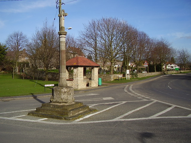
The village centres on the remains of the village cross. The cross is a 14th-century market cross (or buttercross) from which important matters of public moment were announced. The cross, which is listed as a scheduled monument, had restoration work carried out by a Mr CH Fowler between 1903 and 1904.
Cranwell manor was held by the Thorold family from the 16th century for over three hundred years. The manor house was demolished in 1816 and the Hall Farm's farmhouse was erected on the site. The Thorold family moved to a new mansion at Syston Park. In 1871 Sir John Thorold is recorded as owning all the land in Cranwell with the exception of the church glebelands and a single farmstead that was under the ownership of St John's College, Cambridge.
Read more of the history
In 1682, Sir William and his wife Lady Anne Thorold are recorded as establishing a charity that gave about £8 and 2 shillings (£8.10) per year for the poor, to be distributed on Lady Day (25 March and then considered to be New Year's Day). The parish also benefited from the will of Lady Margaret Thorold who granted £15 a year to apprentice four boys from the village. With the Poor Law Amendment Act reforms of 1834, the parish became part of the Sleaford Poor Law Union group of parishes.
Cranwell railway station, on a single track branch line from Sleaford, opened in 1917 and served the naval aviation training facility then known as RNAS Daedalus, later to become RAF Cranwell. The branch line was closed in 1956 and the track removed. However, the original station building still stands and is in use as the current RAF main guardroom. Engine sheds in a small goods yard area closer to the village were demolished and the land re-used for housing.
In 1921, the civil parish had a population of 2191. On 1 April 1931 the parish was abolished and merged with Byards Leap to form "Cranwell and Byards Leap".
From the History section of Cranwell on Wikipedia, under CC BY-SA 4.0.
More about Cranwell
Education
As early as 1682, Sir William and Lady Anne Thorold funded a charity that provided £3 each year for the education of poor children from within the parish. The first true school built in Cranwell opened in 1850 by public subscription and provided facilities for up to 35 children.
The current Cranwell Primary School is housed in a modern building and has approximately 300 children on the roll between the ages of 4–11. The school is a Foundation school and is non-denominational.
There are no secondary schools in the village and children instead travel to Lincoln, Grantham or Sleaford.
From the Wikipedia article Cranwell, under CC BY-SA 4.0.
Notable people from Cranwell
- Sheila CassidyEnglish medical doctor, writer and activist
Born in Cranwell, according to Wikidata (CC0). Each name links to its Wikipedia article.
Gas and EV charging1
Schools, colleges and libraries1
Map of Cranwell
10 places. The map loads OpenStreetMap tiles when you open it.
Getting there and nearby towns
RAF Waddington (WTN) is the nearest airport with scheduled flights listed in OpenStreetMap, 9 miles away.
- Leasingham 2 mi southeast, about 3 min by car
- Sleaford 3 mi southeast, about 6 min by car
- Grantham 11 mi southwest, about 18 min by car
- Lincoln 14 mi north, about 22 min by car
- Newark on Trent 15 mi west, about 24 min by car
- Corby Glen 16 mi south, about 25 min by car
- Sutton on Trent 18 mi northwest, about 29 min by car
- Boston 19 mi east, about 30 min by car
- Bourne 19 mi south, about 30 min by car
- Spalding 22 mi southeast, about 35 min by car
Drive times are estimates from straight-line distance, not routes.
Towns near Cranwell


Keep exploring
Local news
Headlines from INDB.
Reviews, tips and questions
Loading what members have shared...
Sources and licences
- GeoNames (CC BY 4.0): population, coordinates, regions and time zone
- Mapillary (see each image): photos
- OpenStreetMap contributors (ODbL 1.0): places, airports, map data
- Wikidata (CC0 1.0): elevation, founding date, time zone, website, landmarks and historic places
- Wikimedia Commons (see each image): photos
- Wikipedia (CC BY-SA 4.0): overview and history text
Photo credits
- Cranwell Village Centre, Ken Brockway, CC BY-SA 2.0
- Cranwell, St Andrew's church, window detail (26783636037), Jules & Jenny from Lincoln, UK, CC BY 2.0
- Cranwell, St Andrew's church, organ (27782829398), Jules & Jenny from Lincoln, UK, CC BY 2.0
- Cranwell, St Andrew's church interior (40940149824), Jules & Jenny from Lincoln, UK, CC BY 2.0
- Cranwell, St Andrew's church, window detail (40940548174), Jules & Jenny from Lincoln, UK, CC BY 2.0
- Cranwell, St Andrew's church window (39843617570), Jules & Jenny from Lincoln, UK, CC BY 2.0
- Cranwell, St Andrew's church window (39843616520), Jules & Jenny from Lincoln, UK, CC BY 2.0
- Cranwell, St Andrew's church window (39843611810), Jules & Jenny from Lincoln, UK, CC BY 2.0
- Cranwell, St Andrew's church, window detail (41611792372), Jules & Jenny from Lincoln, UK, CC BY 2.0
- Cranwell, St Andrew's church, window detail (40940549924), Jules & Jenny from Lincoln, UK, CC BY 2.0
- Cranwell, St Andrew's church window (39843605360), Jules & Jenny from Lincoln, UK, CC BY 2.0
- Cranwell, St Andrew's church window (39843610470), Jules & Jenny from Lincoln, UK, CC BY 2.0
- Cranwell, St Andrew's church, window detail (27782816208), Jules & Jenny from Lincoln, UK, CC BY 2.0
- Cranwell, St Andrew's church window (39843619480), Jules & Jenny from Lincoln, UK, CC BY 2.0
- Cranwell, St Andrew's church, window detail (41611739552), Jules & Jenny from Lincoln, UK, CC BY 2.0
- Cranwell, St Andrew's church (39843594270), Jules & Jenny from Lincoln, UK, CC BY 2.0
- Cranwell, St Andrew's church window (26783213447), Jules & Jenny from Lincoln, UK, CC BY 2.0
- Cranwell, St Andrew's church, window detail (26783540727), Jules & Jenny from Lincoln, UK, CC BY 2.0
- Cranwell, St Andrew's church, window detail (40760182855), Jules & Jenny from Lincoln, UK, CC BY 2.0
- Cranwell, St Andrew's church window (39843613210), Jules & Jenny from Lincoln, UK, CC BY 2.0
- Cranwell, St Andrew's church window (26783211557), Jules & Jenny from Lincoln, UK, CC BY 2.0
- Cranwell, St Andrew's church window (39843614190), Jules & Jenny from Lincoln, UK, CC BY 2.0
- Sleaford, St Denys, West fassade, -- Rensi 12:54, 28. Dez. 2009 (CET), Public domain
- Street-level photo, southglos, CC BY-SA 4.0
- Street-level photo, southglos, CC BY-SA 4.0
- Street-level photo, southglos, CC BY-SA 4.0


Page built November 10, 2026. Spotted a mistake? Tell us or suggest a place.