


Why visit Friston
Townapedia lists 10 museums and landmarks, 1 park or trail, 3 places to eat and 7 attractions in and around town.
Highlights include Beachy Head Lighthouse, Belle Tout lighthouse, Robertson War Memorial Bequest Obelisk and Neolithic causewayed enclosure on Combe Hill.
Weather in Friston
Forecast from MET Norway (CC BY 4.0). Full forecast
About Friston
East Dean and Friston is a civil parish in the Wealden District of East Sussex, England.The two villages in the parish are in a dry valley on the South Downs – between Eastbourne three miles (4.8 km) to the east and Seaford an equal distance to the west. The main A259 road goes through both village centres. The coast and much of the land between it and the A259 from the east edge of Seaford to the west edge of Eastbourne is owned by the National Trust, and this has prevented further development to the area. The civil parish was formed on 1 April 1999 from "East Dean" and "Friston" parishes.
From the Wikipedia article East Dean and Friston (this version), under CC BY-SA 4.0.
Things to do7

Beachy Head Lighthouse
Lighthouse · 2.8 mi
Lighthouse at Eastbourne, East Sussex, England, UK

Belle Tout lighthouse
Lighthouse · 1.9 mi
Decommissioned lighthouse at Beachy Head, East Sussex, England, UK

Lamb Theatre
Cinema and theater · 3.0 mi
Pub theatre above the Lamb Inn in Old Town, Eastbourne, England

Museums and landmarks10


Neolithic causewayed enclosure on Combe Hill
Monument and historic site · 2.8 mi
Causewayed enclosure in Eastbourne, East Sussex, England, UK
Parks, trails and playgrounds1
Restaurants and cafes3


More about Friston
Geography
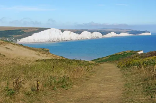
The main rock type at Birling Gap is chalk. Other rock types outcropping here include flint, loess and soil. The coastline is part of the Site of Special Scientific Interest Seaford to Beachy Head, which falls within the parish. The site is of biological and geological interest.
There is also extensive evidence and visible earthworks here of an Iron Age hillfort on the site – although nearly half of it has already been lost to the sea. Information boards at the site show how it would have originally looked; however, even more will be lost due to the geological nature of the chalk cliffs.
From the Wikipedia article East Dean and Friston, under CC BY-SA 4.0.
Churches and places of worship5
Shopping1
Map of Friston
27 places. The map loads OpenStreetMap tiles when you open it.
Getting there and nearby towns
Brighton City Airport (ESH) is the nearest airport with scheduled flights listed in OpenStreetMap, 22 miles away.
- Eastbourne 4 mi east, about 6 min by car
- Seaford 4 mi west, about 7 min by car
- Newhaven 7 mi west, about 11 min by car
- Hailsham 7 mi north, about 12 min by car
- Peacehaven 9 mi west, about 15 min by car
- Herstmonceux 10 mi northeast, about 16 min by car
- Lewes 11 mi northwest, about 18 min by car
- Rottingdean 12 mi west, about 19 min by car
- Bexhill-on-Sea 13 mi northeast, about 21 min by car
- Brighton 15 mi west, about 25 min by car
Drive times are estimates from straight-line distance, not routes.
Towns near Friston


Keep exploring
Local news
Headlines from INDB.
Reviews, tips and questions
Loading what members have shared...
Sources and licences
- GeoNames (CC BY 4.0): population, coordinates, regions and time zone
- Mapillary (see each image): photos
- OpenStreetMap contributors (ODbL 1.0): places, airports, map data
- Wikidata (CC0 1.0): elevation, founding date, time zone, website, landmarks and historic places
- Wikimedia Commons (see each image): photos
- Wikipedia (CC BY-SA 4.0): overview and history text
Photo credits
- Belle Tout Lighthouse 2013, Tom Rayner, CC BY-SA 4.0
- The Lamb Inn, High Street, Old Town, Eastbourne (NHLE Code 1043679) (October 2012), The Voice of Hassocks, CC0
- St Elisabeth's Church, Eastbourne (IoE Code 293633), The Voice of Hassocks, Public domain
- Church of St. Peter ad Vincula, Folkington 02, Simon Burchell, CC BY-SA 4.0
- St Simon and St Jude, East Dean, Poliphilo, CC0
- Robertson War Memorial on The South Downs Way, Enthusiastic sharer, CC BY-SA 4.0
- Beachy Head Lighthouse 3, Mocsarbalazs, CC BY-SA 4.0
- Street-level photo, coljay72, CC BY-SA 4.0
Page built November 10, 2026. Spotted a mistake? Tell us or suggest a place.