


Gamlingay, United Kingdom
Gamlingay is a town of 3,247 people in England, United Kingdom.
Why visit Gamlingay
Townapedia lists 1 museum or landmark, 7 parks and trails, 7 places to eat, 1 place to stay and 1 attraction in and around town.
Highlights include Buff Wood and Gamlingay Cinques Common.
Weather in Gamlingay
Forecast from MET Norway (CC BY 4.0). Full forecast
About Gamlingay
Gamlingay is a village and civil parish in the South Cambridgeshire district of Cambridgeshire, England, about 14 miles (23 km) west southwest of Cambridge.
From the Wikipedia article Gamlingay (this version), under CC BY-SA 4.0.
Things to do1

Museums and landmarks1

Parks, trails and playgrounds7


Gamlingay Cinques Common
Park · 0.8 mi
Nature reserve in the United Kingdom


Gransden and Waresley Woods
Park · 2.1 mi
Nature reserve in the United Kingdom



Restaurants and cafes7





History
An ancient village listed in the Domesday Book of 1086, the name comes from the Old English Gamelingei, meaning "the enclosure of Gamela's people".
There has been a settlement on the site since the middle Bronze Age and there are signs of occupation from the middle Stone Age. The village may have first been established around a central green south of the High Street (now known as Church Street); a complex of medieval buildings stood at the east end of the green, but only a house known as 'The Emplins' remains today. Another focal point was provided by the crossroads at the other end of Church Street and houses spread to the south and east of the junction. In the 16th and 17th centuries, Gamlingay grew to the east towards Dutter End and west to Green End. By 1871, Gamlingay had a population twice as large as that of the hundred's second-largest parish, Bourn.
Gamlingay is steeped in history, with many listed buildings in the village. The stone for building the church was from a quarry within the village. This quarry then offered the perfect location for an archery range. Being dug into the ground it was a safe area where archery could be practised, and thus was named 'The Butts'. In medieval times it was a requirement that all men over a certain age were capable of using a bow and arrow. The Butts is now a children's play area.
Read more of the history
Throughout history, Gamlingay has been a farming village. Most of the village was owned by the Oxford college Merton, and the Cambridge colleges Downing and Clare. Until a few years ago, the houses at Gamlingay Village College were named after Merton, Downing and Clare. Downing College acquired the land as a result of a bequest in the will of Sir George Downing, who lived in a mansion, Gamlingay Park, on his Gamlingay estate.
In 1600, 64 houses – comprising much of the village – were destroyed in the "Great Fire of Gamlingay", as described in an extract of a letter from the Privy Council to Sir Thomas Egerton:
"Whereas divers of the Justices of the Peace in the countie of Cambridge have certyfied us the lamentable accydent that hath fallen upon the inhabitantes of Gamlingay in the said countie, by casualltie of fire that happned on the 21St daie of Aprill last, whereby the moste parte of the said towne to the nomber of 76 houses with divers barnes and stackes of corne were suddainlie consumed."
By 1844, Gamlingay had five inns, including the Cock (dating from at least 1588), the Rose & Crown (1622) and the Blue Ball (1770s). The Sultan was built near the station in 1867.
Gamlingay railway station on the Bedford and Cambridge branch of the London and North Western Railway, was in operation from 1862 until 1968.
From the History section of Gamlingay on Wikipedia, under CC BY-SA 4.0.
More about Gamlingay
Geography
Gamlingay is 14 miles (22 km) west of the county town of Cambridge, five miles (9 km) south-east of St Neots and 45 miles (72 km) north of London. It is north of the small town of Potton and south-west of Waresley. The parish ranges from 39 metres (along the Millbridge Brook) to 73 metres (near Potton Wood) above sea level. The village is at around 50 metres. Most of the central parish is on the Lower Greensand; the soil in the eastern part of the parish is clay with gault subsoil. Two nature reserves, Gamlingay Wood and Gamlingay Cinques Common (registered Town and Village Green No. 39) can be found in the parish, the former and the latter being a Site of Special Scientific Interest and a County Wildlife Site respectively.
By the 12th century, heathland had developed on the Lower Greensand and the poor drainage of the soil there meant there were two quaking bogs, on Gamlingay Heath (drained in 1855) and Cinques Common. Treeplanting and pig rearing after inclosure in 1844 altered the landscape.
Woodbury used to be in the parish but was transferred to Bedfordshire in 1965 and a hamlet named Newton on the Heath had disappeared by 1279.
Economy
Gamlingay is now largely a commuter village: 44% of its employed residents work outside of Cambridgeshire, 30% more than 20 km away and 11% more than 40 km away.
Farming, mainly arable, was the primary employer in Gamlingay for many centuries. A third of the parish was cultivated in 1801, with wheat the main crop, then barley and peas. In 1937, there were 12 smallholders and 11 market gardeners. There was some gravel extraction south of the village in the late 19th century; in 1864 the village had three brickworks. In 1912, one occupied an area of 31 acres (12.5 hectares), with 12 kilns and a warehouse capable of holding 500,000 bricks. The closure of the brick and tile works probably caused the parish's population to fall in the aftermath of its sale in 1920.
Education
Until 2017, Gamlingay children were educated under the neighbouring Bedfordshire three-tier system but the village aligned with the nationally recognised two-tier system from September 2017. Gamlingay children aged 4–11 years are now educated at Gamlingay Village Primary, part of the Cam Academy Trust. (As Gamlingay Village College it was previously a Middle school and admitted pupils aged from 9–13). Secondary education follows at Comberton Village College (also a Cam Academy Trust school), Ofsted rated Outstanding, with free school bus provided for 11 - 16 year olds. The nearest secondary schools are Sandy Secondary School and Stratton Upper School, Biggleswade.
From the Wikipedia article Gamlingay, under CC BY-SA 4.0.
Notable people from Gamlingay

Born in Gamlingay, according to Wikidata (CC0). Each name links to its Wikipedia article.
Where to stay1
Churches and places of worship8
Shopping2
Gas and EV charging2
Schools, colleges and libraries1
Healthcare1
Map of Gamlingay
31 places. The map loads OpenStreetMap tiles when you open it.
Getting there and nearby towns
Cambridge City Airport (CBG) is the nearest airport with scheduled flights listed in OpenStreetMap, 16 miles away.
- Great Gransden 3 mi northeast, about 5 min by car
- Sandy 4 mi southwest, about 7 min by car
- Saint Neots 5 mi northwest, about 8 min by car
- Biggleswade 6 mi southwest, about 9 min by car
- Great Barford 7 mi west, about 11 min by car
- Little Paxton 7 mi northwest, about 11 min by car
- Papworth Everard 7 mi northeast, about 12 min by car
- Langford 8 mi southwest, about 12 min by car
- Bassingbourn 8 mi southeast, about 13 min by car
- Orwell 8 mi east, about 13 min by car
Drive times are estimates from straight-line distance, not routes.
Towns near Gamlingay


Keep exploring
Local news
Headlines from INDB.
Reviews, tips and questions
Loading what members have shared...
Sources and licences
- GeoNames (CC BY 4.0): population, coordinates, regions and time zone
- Mapillary (see each image): photos
- OpenStreetMap contributors (ODbL 1.0): places, airports, map data
- Wikidata (CC0 1.0): elevation, founding date, time zone, website, landmarks and historic places
- Wikimedia Commons (see each image): photos
- Wikipedia (CC BY-SA 4.0): overview and history text
Photo credits
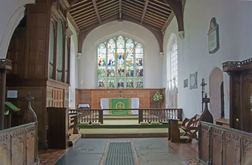
- Stmarys gamlingay 3173, Bogbumper, CC BY-SA 3.0
- Buffwood 4171, Bogbumper, CC BY-SA 3.0
- Gamlingay Cinques 4, Dudley Miles, CC BY-SA 4.0
- Gamlingay Wood 8, Dudley Miles, CC BY-SA 4.0
- Waresleywood 3996, Bogbumper, CC BY-SA 3.0
- Hayley Wood 7, Dudley Miles, CC BY-SA 4.0
- Churchstdenis 4216, Bogbumper, CC BY-SA 3.0
- St Margaret's church in Abbotsley, Cambs, Fivemack at English Wikipedia, Public domain
- Gamlingay, My another account ( talk ), CC0
- Church of All Saints, Sutton (Bedfordshire) 2019-02, Dbrooker, CC BY-SA 4.0
- Street-level photo, coljay72, CC BY-SA 4.0


Page built November 10, 2026. Spotted a mistake? Tell us or suggest a place.