
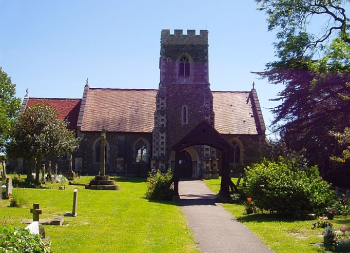


Papworth Everard, United Kingdom
Papworth Everard is a town of 2,880 people in England, United Kingdom.
Why visit Papworth Everard
Townapedia lists 1 museum or landmark, 2 parks and trails and 6 places to eat in and around town.
Highlights include Cambourne Nature Reserve and Overhall Grove.
Weather in Papworth Everard
Forecast from MET Norway (CC BY 4.0). Full forecast
About Papworth Everard
Papworth Everard is a village in Cambridgeshire, England. It lies ten miles west of Cambridge and six miles south of Huntingdon. Running through its centre is Ermine Street, the old North Road (now the A1198) and the Roman highway that for centuries served as a major artery from London to York. A bypass now means that most traffic can avoid Ermine Street, and it is traffic-calmed within the village itself.
From the Wikipedia article Papworth Everard (this version), under CC BY-SA 4.0.
Museums and landmarks1

Parks, trails and playgrounds2
Cambourne Nature Reserve
Park · 2.8 mi
Nature reserve in the United Kingdom

Overhall Grove
Park · 3.1 mi
Nature reserve in Cambridgeshire, England, UK
Restaurants and cafes6


Churches and places of worship6


St John the Baptist Church
Church · Anglican · 1.4 mi
The Church Lane, Papworth St Agnes
St John the Baptist's Church, Papworth St Agnes
Church · 1.4 mi
Church in South Cambridgeshire, England, UK
History
Recent archaeological work in the area of the Papworth Business Park has shown that there was some Bronze Age activity in the area. In the Roman period when Ermine Street was built, in the first century AD, it is unlikely that there was as yet anything which would now be recognised as a village there. However, the same archaeological work does show signs of Romano-British activity, as well as the road. Roman rule collapsed in Britain in 410 AD. It was at least another two or three centuries before a Saxon leader, probably called 'Papa', established a small settlement about a quarter of a mile to the west of Ermine Street around the site of the present parish church. Indeed, Papworth means "the enclosure of Papa's people"; they were also involved in establishing Papworth St Agnes and Papley Grove. Following the Norman Conquest of 1066, the village and land of Papworth were granted by the new king to a Norman knight, Everard De Beche, from whose name the second element of the village's name is derived. A moated area in the village is the remains of his castle.
From the History section of Papworth Everard on Wikipedia, under CC BY-SA 4.0.
Shopping1
Gas and EV charging1
Schools, colleges and libraries3
Healthcare1
Map of Papworth Everard
21 places. The map loads OpenStreetMap tiles when you open it.
Getting there and nearby towns
Cambridge City Airport (CBG) is the nearest airport with scheduled flights listed in OpenStreetMap, 13 miles away.
- Great Gransden 5 mi south, about 7 min by car
- Saint Ives 6 mi north, about 10 min by car
- Huntingdon 6 mi northwest, about 10 min by car
- Swavesey 6 mi northeast, about 10 min by car
- Houghton 6 mi north, about 9 min by car
- Saint Neots 7 mi west, about 11 min by car
- Needingworth 7 mi northeast, about 11 min by car
- Comberton 7 mi southeast, about 12 min by car
- Longstanton 7 mi east, about 12 min by car
- Oakington 8 mi east, about 13 min by car
Drive times are estimates from straight-line distance, not routes.
Towns near Papworth Everard


Keep exploring
Local news
Headlines from INDB.
Reviews, tips and questions
Loading what members have shared...
Sources and licences
- GeoNames (CC BY 4.0): population, coordinates, regions and time zone
- Mapillary (see each image): photos
- OpenStreetMap contributors (ODbL 1.0): places, airports, map data
- Wikidata (CC0 1.0): elevation, founding date, time zone, website, landmarks and historic places
- Wikimedia Commons (see each image): photos
- Wikipedia (CC BY-SA 4.0): overview and history text
Photo credits
- Papworth Everard St Peter, User:Faeden1, Public domain
- Overhall Grove 4, Dudley Miles, CC BY-SA 4.0
- Holy Cross church, Yelling, Cambs, User:Fivemack, Public domain
- Papworth hospital, Tom Womack, Public domain
- Street-level photo, adam2, CC BY-SA 4.0
- Street-level photo, adam2, CC BY-SA 4.0
- Street-level photo, adam2, CC BY-SA 4.0
- Street-level photo, adam2, CC BY-SA 4.0
- Street-level photo, adam2, CC BY-SA 4.0
- Street-level photo, adam2, CC BY-SA 4.0
- Street-level photo, adam2, CC BY-SA 4.0
- Street-level photo, adam2, CC BY-SA 4.0
Page built November 10, 2026. Spotted a mistake? Tell us or suggest a place.