
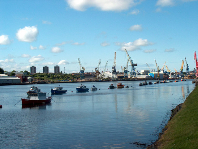


Why visit Hebburn
Townapedia lists 19 museums and landmarks, 10 parks and trails, 137 places to eat, 3 places to stay and 6 attractions in and around town.
Highlights include Customs House, South Shields, Gateshead Millennium Bridge, Segedunum and Baltic Centre for Contemporary Art.
Weather in Hebburn
Forecast from MET Norway (CC BY 4.0). Full forecast
About Hebburn
Hebburn is a town in the South Tyneside borough of Tyne and Wear, England. It was historically in County Durham and became part of Tyne and Wear in 1974. It is on the south bank of the River Tyne between Gateshead and Jarrow and opposite Wallsend and Walker. At the 2021 census the Hebburn built up area as defined by the Office for National Statistics had a population of 21,345.
From the Wikipedia article Hebburn (this version), under CC BY-SA 4.0.
Photos of Hebburn


Things to do6

Customs House, South Shields
Cinema and theater · 3.3 mi
Theatre, cinema and art gallery in South Shields, England

Gateshead Millennium Bridge
Bridge · 3.4 mi
Pedestrian and cyclist tilt bridge spanning the River Tyne in England between Gateshead and Newcastle upon Tyne


People's Theatre
Cinema and theater · 3.0 mi
Theatre and former cinema in Newcastle upon Tyne, England

Byker Bridge
Bridge · 3.1 mi
Road bridge in Newcastle upon Tyne, Tyne and Wear, England

Museums and landmarks19


Baltic Centre for Contemporary Art
Museum · 3.3 mi
Art gallery in Gateshead, Tyne and Wear.
Castrum Segedunum
Monument and historic site · 1.2 mi
Roman fort in Wallsend, North Tyneside, Tyne and Wear, England, UK

Jarrow Hall
Museum · 1.8 mi
Museum in Jarrow, England, United Kingdom

Stephenson Railway Museum
Museum · 3.1 mi
Railway museum in North Shields, United Kingdom

The Biscuit Factory
Museum · 3.3 mi
Art gallery in Newcastle upon Tyne, England, UK

Jobling Memorial
Monument and historic site · 1.5 mi
About Jobling: www.capitalpunishmentuk.org/William%20Jobling.html
Tyne Street

Seven Stories
Museum · 3.0 mi
Museum and visitor centre in Newcastle, United Kingdom

7 more on the map.
Parks, trails and playgrounds10


Rising Sun Country Park
Park · 2.6 mi
Country park in North Tyneside, England

Restaurants and cafes137

Kaycho
Restaurant · Indian · 1.4 mi
62-64 Station Road, Wallsend
Mo-Th 17:00-22:00; Fr 12:30-14:30, 17:00-23:00; Sa 12:30-23:00; Su...

The Anson
Bar and pub · 1.5 mi
Station Road, Wallsend
Mo-Th 10:00-23:00; Fr-Sa 10:00-00:00; Su 10:00-23:00
The Ritz
Bar and pub · 1.5 mi
87-93 High Street West, Wallsend
Mo-Th 08:00-00:00; Fr-Sa 08:00-01:00; Su 08:00-00:00

Browns Cafe
Cafe · Coffee Shop, Breakfast, Burger, Cake, Ice Cream, Regional, Sausage, Sandwich, Tea
9a Station Road, Hebburn
Mo-Sa 08:00-16:00; Su 11:00-18:00

Milligans
Bakery · 1.5 mi
4 The Forum, Wallsend
Mo-Sa 08:00-17:00; Su 10:00-16:00
125 more on the map.
History
In Saxon times Hebburn was a small fishing hamlet upon the river Tyne. It is thought that the name Hebburn may be derived from the Old English terms, heah meaning "high", and byrgen meaning a "burial mound", though it could also mean the high place beside the water. The first record of Hebburn mentions a settlement of fishermen's huts in the 8th century, which were burned by the Vikings.
In the 14th century, the landscape was dominated by a peel tower. A 4-foot-6-inch-tall (137-centimetre) wall, a portion of which still remains at St. John's Church, could also be seen. The Lordship of the Manor of Hebburn passed through the hands of a number of families during the Middle Ages, including the Hodgsons of Hebburn (James 1974, Hodgson).
In the early 1600s, the wealthy Newcastle family, the Ellisons, acquired the land of Hebburn. Coal was mined at Hebburn as early as the 17th century. In 1792 the Ellisons received royalties from coal mining expansion when Hebburn Colliery opened. The colliery eventually operated three pits. In 1786 the Ellisons’ Hebburn estate also made income from dumping ships ballast at Hebburn Quay. By the 1800s the Ellison family had expanded Hebburn Manor into their Hebburn Hall estate. Hebburn Colliery played an important role in the investigations into the development of mine safety, following the mining disaster at Felling Colliery in 1812.
Read more of the history
Humphry Davy stayed with Cuthbert Ellison at Hebburn Hall in 1815 and took samples of the explosive methane 'fire damp' gas from the Hebburn mine which were taken to London in wine bottles for experiments into the development of a miners' safety lamp. Davy's lamps were tested in the Hebburn mine and remarkably the gauze that protected the naked flames could actually absorb the fire damp so that the lamps could shine more effectively.
In 1853, Andrew Leslie arrived from Aberdeen, Scotland. He expanded the Ellison estate, further, with shipbuilding, and in 200 years of industrialisation, Hebburn grew into a modern town of 20,000 inhabitants. When the railways arrived in Hebburn in 1872, further growth took off in the Ellison estate, with the growth of the brick, metal and chemical industries.
Andrew Leslie's shipyard launched two hundred and fifty-five ships before 1885. In 1885 the shipyard merged with local locomotive builder W Hawthorne, and then changed its name to Hawthorn Leslie and Company, and grew even more.
Hebburn also hosted its own Highland Games, with the first one being held in 1883, which were usually held annually in July or August, spanning over three decades and with professional sportsmen coming from Scotland and as far as Oban to compete.
In 1901, Alphonse Reyrolle's, Reyrolle Electrical Switchgear Company opened. In 1932 Hebburn colliery closed. 200 miners were killed during the life of the colliery. The youngest were 10 years old. In 1936 Monkton Coke Works was built by the Government, in response to the Jarrow Hunger March in 1932.
In the Second World War, the Battle of Britain occurred in 1940, and Hitler had planned an amphibious attack that was predicated on defeating the RAF in the battle. Hitler's planned first wave of attack, in his Operation Sea Lion plan, was to try to capture Aberdeen and Newcastle. Hitler's Operation Sea Lion documents had detailed plans to capture the Reyrolle Electrical Switchgear Company.
Hawthorn Leslie built everything from liners to tankers. Many Royal Navy battleships were built at Hawthorn Leslie shipyard. In WWII the yard built 41 naval vessels and repaired another 120. In 1944, the yard also built D-day landing craft, including the Landing Craft Tank (LCT) 7074. In April 2020, the craft was housed in the D-Day Story museum. In 2020, the boat was only one of ten craft of its kind to survive postwar.
One ship built at the shipyard was HMS Kelly, launched in 1938 and commanded by Lord Louis Mountbatten. The ship, a K-Class destroyer, was commissioned just eleven days before WWII. The ship was hit three times. In December 1939, she was damaged by a German mine not far from the river Tyne. On 9 May 1940, she was torpedoed off Norway with the loss of 27 lives. Badly damaged, she crawled back to Hawthorn Leslie on a 92-hour journey to be repaired. In 1941, HMS Kelly was sunk off Crete. One hundred and thirty men were killed in the disaster and they are remembered in memorials at Hebburn Cemetery, which were erected by surviving members of the crew and workers from Hawthorn Leslie. The ship's story forms the basis of the 1942 film In Which We Serve. The shipyard is now owned by Hebburn Riverside Development Limited and construction has commenced for a landmark residential development called Kelly's Wharf.
The Monkton Coke Works plant closed in 1990, and was demolished in 1992. The former British Short-Circuit Testing Station in Victoria Road West within the town, owned by A. Reyrolle & Company provided the backdrop for the Gary Numan video "Metal". The facility was demolished in 2011.
In 2012, the BBC commissioned a television series Hebburn to be set in the town. It was created and co-written by Jason Cook, who was raised in Hebburn. The first episode was broadcast on 18 October 2012.
4th Battalion the Parachute Regiment and 23 SAS Reserves have bases in Hebburn. The Air Cadets have a unit located at Hebburn TA Centre.
Hebburn has an ecology centre powered by wind turbines. It is the location of a shipyard, operated by A&P Group.
From the History section of Hebburn on Wikipedia, under CC BY-SA 4.0.
More about Hebburn
Education
Hebburn has two secondary schools: St Joseph's Catholic Academy (formerly St Joseph's Comprehensive School) and Hebburn Comprehensive School.
From the Wikipedia article Hebburn, under CC BY-SA 4.0.
Notable people from Hebburn
 Chris RiggEnglish footballerPhoto: Timmy96, CC0
- Brendan FosterAthletics competitor, long distance runner
- Chris BashamEnglish association football player (born 1988)
- Ray WoodEnglish footballer (1931-2002)
- David WilsonEnglish footballer (1908-1992)
- Pat BurkeEnglish professional association footballer (1892-?)
- Gerry CoyneEnglish footballer (born 1948)
- Alfred Douglasfootballer (1899-?)
- Bob BarnshawEnglish professional footballer (1889-1974)
- Dominic BruceRAF officer
- Jack EnglishEnglish footballer and manager (1886-1953)
- Baden PowellEnglish footballer (1931-2014)
Born in Hebburn, according to Wikidata (CC0). Each name links to its Wikipedia article.
Where to stay3
Churches and places of worship29
St Oswalds Parish C Of E Church
Church · Anglican · 0.7 mi
St Oswald's Road, Hebburn
Shopping22
Gas and EV charging3
Schools, colleges and libraries30
St Alban's Catholic Primary School
School · Roman Catholic · 1.4 mi
Westbourne Avenue, Newcastle upon Tyne
Healthcare23
Map of Hebburn
250 places. The map loads OpenStreetMap tiles when you open it.
Getting there and nearby towns
Newcastle International Airport (NCL) is the nearest airport with scheduled flights listed in OpenStreetMap, 8 miles away.
- Jarrow 1 mi east, about 2 min by car
- Newcastle upon Tyne 4 mi west, about 6 min by car
- Sunderland 7 mi southeast, about 11 min by car
- Whickham 7 mi west, about 11 min by car
- Ryhope 9 mi southeast, about 15 min by car
- Ponteland 11 mi northwest, about 17 min by car
- Hetton-Le-Hole 11 mi south, about 18 min by car
- Seaham 11 mi southeast, about 18 min by car
- Prudhoe 13 mi west, about 21 min by car
- Morpeth 15 mi northwest, about 24 min by car
Drive times are estimates from straight-line distance, not routes.
Towns near Hebburn


Keep exploring
Local news
Headlines from INDB.
Reviews, tips and questions
Loading what members have shared...
Sources and licences
- GeoNames (CC BY 4.0): population, coordinates, regions and time zone
- Mapillary (see each image): photos
- OpenStreetMap contributors (ODbL 1.0): places, airports, map data
- Wikidata (CC0 1.0): elevation, founding date, time zone, website, landmarks and historic places
- Wikimedia Commons (see each image): photos
- Wikipedia (CC BY-SA 4.0): overview and history text
Photo credits
- Hebburn - Riverside, Mike Ellison, CC BY-SA 2.0
- Hebburn central (39571238722), JuliaC2006 from Rochester, UK, CC BY-SA 2.0
- Children's section in Hebburn library (39571242092), JuliaC2006 from Rochester, UK, CC BY-SA 2.0
- Hebburn library (25729922918), JuliaC2006 from Rochester, UK, CC BY-SA 2.0
- Gateshead millennium bridge open, Mike1024, Public domain
- Jarrow Bridge3, MSGJ, CC BY-SA 4.0
- Peoples Theatre, Heaton, Newcastle, John-Paul Stephenson, CC BY-SA 3.0
- Jarrow Hall, Jarrow, Tyne and Wear (4535471011), Orangeaurochs from Sandy, Bedfordshire, United Kingdom, CC BY 2.0
- E4 in the Stephenson Railway Museum, Robby George, CC0
- The Biscuit Factory, Frombowen, CC BY-SA 4.0
- P&GCobalt, Andy Connolly, Public domain
- St Dominic's Church, Newcastle, Andrew Curtis, CC BY-SA 2.0
- St Peter's Church, Wallsend, CramptonHodnet, CC BY-SA 4.0
- Jarrow, Xaphire at Dutch Wikipedia, CC BY-SA 3.0
- St Luke's Church Wallsend, CramptonHodnet, CC BY-SA 4.0
- William Jobling memorial, Juroreight, CC0
- TWAM Ref- TWCMS-M4408 (21597342776), Tyne & Wear Archives & Museums, No restrictions
- TWAM Ref- TWCMS-M4445 (21438187170), Tyne & Wear Archives & Museums, No restrictions
- TWAM Ref- TWCMS-M4402 (21434799320), Tyne & Wear Archives & Museums, No restrictions
- 7 February 1919 (21434799360), Tyne & Wear Archives & Museums, No restrictions
- TWAM Ref- TWCMS-M4419 (21624377165), Tyne & Wear Archives & Museums, No restrictions
- 30 November 1919 (21613295492), Tyne & Wear Archives & Museums, No restrictions
- TWAM Ref- TWCMS-M4411 (21624377085), Tyne & Wear Archives & Museums, No restrictions
- TWAM Ref- TWCMS-M4418 (21434799280), Tyne & Wear Archives & Museums, No restrictions
- 7 February 1919 (21597342666), Tyne & Wear Archives & Museums, No restrictions
- TWAM Ref- TWCMS-M4414 (21624377145), Tyne & Wear Archives & Museums, No restrictions
- TWAM Ref- TWCMS-M4442 (21004482263), Tyne & Wear Archives & Museums, No restrictions
- The Customs House, South Shields - blue plaque, South Tyneside Council, CC BY-SA 4.0
- Roman statue at Segedunum Fort, Wallsend, RandomPsychic, CC BY-SA 4.0
- Baltic Centre for Contemporary Art, 5 January 2012 (1), Neil Turner from Sowerby Bridge, United Kingdom, CC BY-SA 2.0
- Street-level photo, livingwithdragons, CC BY-SA 4.0
- Street-level photo, floatingboater, CC BY-SA 4.0
- Street-level photo, floatingboater, CC BY-SA 4.0
- Street-level photo, floatingboater, CC BY-SA 4.0
- Street-level photo, floatingboater, CC BY-SA 4.0
- Street-level photo, floatingboater, CC BY-SA 4.0


Page built November 10, 2026. Spotted a mistake? Tell us or suggest a place.