



Hillside, United Kingdom
Hillside is a town of 1,170 people in Scotland, United Kingdom.
Why visit Hillside
Townapedia lists 13 museums and landmarks, 7 parks and trails, 7 places to eat and 3 attractions in and around town.
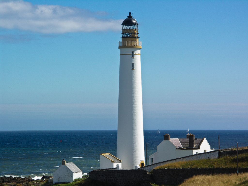
Highlights include Lower North Water Bridge, Scurdie Ness Lighthouse, Montrose Air Station Heritage Centre and Montrose Museum.
Weather in Hillside
Forecast from MET Norway (CC BY 4.0). Full forecast
About Hillside
Hillside is a small private village in Angus, Scotland, situated 5 miles to the north of Montrose. The village is the location for the now disused psychiatric hospital, Sunnyside Royal Hospital. The hospital which was founded by Susan Carnegie in 1781 as the Montrose Lunatic Asylum, Infirmary and Dispensary had originally been situated on Montrose links. It moved out of the town to new premises at Hillside on lands that were part of Sunnyside farm in 1858.
From the Wikipedia article Hillside, Angus (this version), under CC BY-SA 4.0.
Photos of Hillside

Things to do3

Lower North Water Bridge
Bridge · 0.9 mi
Bridge in Aberdeenshire, Scotland

Scurdie Ness Lighthouse
Lighthouse · 3.3 mi
Lighthouse in Angus, Scotland, UK

Museums and landmarks13

Montrose Air Station Heritage Centre
Museum · 1.4 mi
Aviation museum in Montrose, Angus, Scotland, UK

Montrose Museum
Museum · 2.4 mi
Museum in Montrose, Angus, Scotland, United Kingdom

Stone of Morphie
Monument and historic site · 0.8 mi
Standing stone in Aberdeenshire, Scotland, UK
Rosemount House
Monument and historic site · 0.7 mi
Site of now-demolished country house
1 more on the map.
Parks, trails and playgrounds7

Montrose Basin
Park · 2.8 mi
River estuary and nature reserve in Angus, Scotland, UK

St Cyrus National Nature Reserve
Park · 2.5 mi
Scottish nature reserve

Restaurants and cafes7




Churches and places of worship4
Dun and Hillside Parish Church
Church · Church Of Scotland · 0.4 mi
Old School Way, Hillside
The Church of Jesus Christ of Latter-day Saints
Church · Latter Day Saints · 1.1 mi
50 Coronation Way, Montrose
Shopping1
Gas and EV charging1
Schools, colleges and libraries2
Map of Hillside
38 places. The map loads OpenStreetMap tiles when you open it.
Getting there and nearby towns
Dundee Airport (DND) is the nearest airport with scheduled flights listed in OpenStreetMap, 29 miles away.
- Montrose 2 mi south, about 3 min by car
- Saint Cyrus 3 mi northeast, about 5 min by car
- Arbroath 13 mi south, about 21 min by car
- Forfar 17 mi southwest, about 28 min by car
- Stonehaven 18 mi northeast, about 29 min by car
- Carnoustie 19 mi southwest, about 30 min by car
- Dundee 27 mi southwest, about 43 min by car
- Westhill 29 mi north, about 47 min by car
- Aberdeen 31 mi northeast, about 50 min by car
- Saint Andrews 31 mi southwest, about 49 min by car
Drive times are estimates from straight-line distance, not routes.
Towns near Hillside


Keep exploring
Local news
Headlines from INDB.
Reviews, tips and questions
Loading what members have shared...
Sources and licences
- GeoNames (CC BY 4.0): population, coordinates, regions and time zone
- Mapillary (see each image): photos
- OpenStreetMap contributors (ODbL 1.0): places, airports, map data
- Wikidata (CC0 1.0): elevation, founding date, time zone, website, landmarks and historic places
- Wikimedia Commons (see each image): photos
- Wikipedia (CC BY-SA 4.0): overview and history text
Photo credits
- Maltings and Distillery near Hillside, Stanley Howe, CC BY-SA 2.0
- Scurdie Ness Lighthouse, Kevan Dickin, CC BY-SA 3.0
- Montrose Museum, Russ Hamer, CC BY-SA 3.0
- Montrose Basin, friedfish, Public domain
- Auldkirk, Dona Robbins, CC BY-SA 2.0
- MASHC, Kevan Dickin, CC BY-SA 3.0
- Montrose Air Station, Kevan Dickin, CC BY-SA 4.0
- The North Water Viaduct and Lower North Water Bridge, Thomas Fuhrmann, CC BY-SA 4.0
- Street-level photo, drnoble, CC BY-SA 4.0
- Street-level photo, drnoble, CC BY-SA 4.0
- Street-level photo, drnoble, CC BY-SA 4.0
Page built November 10, 2026. Spotted a mistake? Tell us or suggest a place.