


Inkberrow, United Kingdom
Inkberrow is a town of 1,552 people in England, United Kingdom.
Why visit Inkberrow
Townapedia lists 4 museums and landmarks, 3 parks and trails and 10 places to eat in and around town.
Highlights include Ragley Hall, Jerwood Foundation's sculpture collection, Grafton Wood and River Arrow Nature Reserve.
Weather in Inkberrow
Forecast from MET Norway (CC BY 4.0). Full forecast
About Inkberrow
Inkberrow is a village in Worcestershire, England. In 2001, it had a population of 5,308, and 2,170 households.
From the Wikipedia article Inkberrow (this version), under CC BY-SA 4.0.
Museums and landmarks4

Ragley Hall
Museum · 3.7 mi
Grade I listed historic house museum in Stratford-on-Avon, United Kingdom


Inkberrow Castle
Monument and historic site
Castle in Inkberrow, Worcestershire, England, UK
Derelict Royal Observer Corps Monitoring Post - Inkberrow
Monument and historic site
Parks, trails and playgrounds3

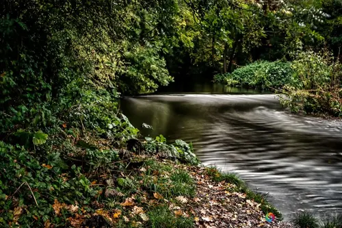
River Arrow Nature Reserve
Park · 4.5 mi
In Alcester, Warwickshire, England

Restaurants and cafes10

Churches and places of worship13

1 more on the map.
History
The earliest recorded version of the village is Intanbeorgas, "Inta's mounds or barrows", from 789. By the 15th century, the spelling may have become Ingtebarwe; nearby villages also mentioned include Church Lench, Abbots Morton and Arrow. By the 16th century, it was known as Inkebarrow.
The area was within Feckenham Forest, a royal forest with harsh forest law punishments.
Cookhill Priory stood 3 mi (4.8 km) to the east, at the edge of the county.
In 2006 Inkberrow was awarded the title of Worcestershire Village of the Year and won the Building Community Life section of the competition.
Inkberrow was identified as a potential site for a new town in the 1960s, but this plan was not carried out. 275 properties were built in the village between 1969 and 1972. More houses were built in the village in 2013. In 2016, 100 new houses were built by Bovis Homes.
Inkberrow Millennium Green is an eight-acre public open space to the east of the village, opened in 2000, which includes a medieval moat and fishpond, a variety of wildflowers and fruit trees, and a millennium seat with extensive views.
Read more of the history
In 2024, The Daily Telegraph reported that a "class war" was taking place in the village. There was disagreement over plans to increase seating at the local football ground. The reporter said that "There are also fears that more developments will follow, and that Inkberrow may one day lose its village status and become a small town".
From the History section of Inkberrow on Wikipedia, under CC BY-SA 4.0.
Notable people from Inkberrow
- Ruth EnglandBritish actress
Born in Inkberrow, according to Wikidata (CC0). Each name links to its Wikipedia article.
Gas and EV charging1
Schools, colleges and libraries2
Map of Inkberrow
33 places. The map loads OpenStreetMap tiles when you open it.
Getting there and nearby towns
Birmingham Airport (BHX) is the nearest airport with scheduled flights listed in OpenStreetMap, 19 miles away.
- Redditch 7 mi north, about 11 min by car
- Stoke Prior 7 mi northwest, about 12 min by car
- Droitwich 8 mi northwest, about 13 min by car
- Evesham 8 mi south, about 14 min by car
- South Littleton 8 mi southeast, about 13 min by car
- Bromsgrove 9 mi north, about 15 min by car
- Wilmcote 9 mi east, about 15 min by car
- Worcester 10 mi west, about 17 min by car
- Stratford-upon-Avon 12 mi east, about 19 min by car
- Solihull 16 mi northeast, about 26 min by car
Drive times are estimates from straight-line distance, not routes.
Towns near Inkberrow


Keep exploring
Local news
Headlines from INDB.
Reviews, tips and questions
Loading what members have shared...
Sources and licences
- GeoNames (CC BY 4.0): population, coordinates, regions and time zone
- Mapillary (see each image): photos
- OpenStreetMap contributors (ODbL 1.0): places, airports, map data
- Wikidata (CC0 1.0): elevation, founding date, time zone, website, landmarks and historic places
- Wikimedia Commons (see each image): photos
- Wikipedia (CC BY-SA 4.0): overview and history text
Photo credits
- Ragley Hall Chadwick 01, Amanda Slater from Coventry, England, CC BY-SA 2.0
- Thecla betulae . topside - Flickr - gailhampshire, gailhampshire from Cradley, Malvern, U.K, CC BY 2.0
- Ragley Hall from the south-west 2006, DeFacto, CC BY-SA 4.0
- Street-level photo, southglos, CC BY-SA 4.0
- Street-level photo, southglos, CC BY-SA 4.0
- Street-level photo, willtudor, CC BY-SA 4.0
- Street-level photo, southglos, CC BY-SA 4.0
- Street-level photo, southglos, CC BY-SA 4.0
- Street-level photo, southglos, CC BY-SA 4.0
- Street-level photo, southglos, CC BY-SA 4.0
- Street-level photo, southglos, CC BY-SA 4.0
- Street-level photo, southglos, CC BY-SA 4.0
- Street-level photo, richardc, CC BY-SA 4.0
Page built November 10, 2026. Spotted a mistake? Tell us or suggest a place.