


Kidderminster, United Kingdom
Kidderminster is a town of 57,400 people in England, United Kingdom.
Why visit Kidderminster
Townapedia lists 21 museums and landmarks, 27 parks and trails, 112 places to eat, 3 places to stay and 3 attractions in and around town.
Highlights include Bewdley Bridge, Lume Cinema, Museum of Carpet and Bewdley Museum.
Weather in Kidderminster
Forecast from MET Norway (CC BY 4.0). Full forecast
About Kidderminster
Kidderminster is a market town and civil parish in Worcestershire, England, 18 miles (29 km) south-west of Birmingham and 15 miles (24 km) north of Worcester. Located north of the River Stour and east of the River Severn, in the 2021 census, it had a population of 57,400. The town is twinned with Husum, Germany.
From the Wikipedia article Kidderminster (this version), under CC BY-SA 4.0.
Travel tips from other travellers: Kidderminster on Wikivoyage (CC BY-SA 4.0).
Photos of Kidderminster

Things to do3

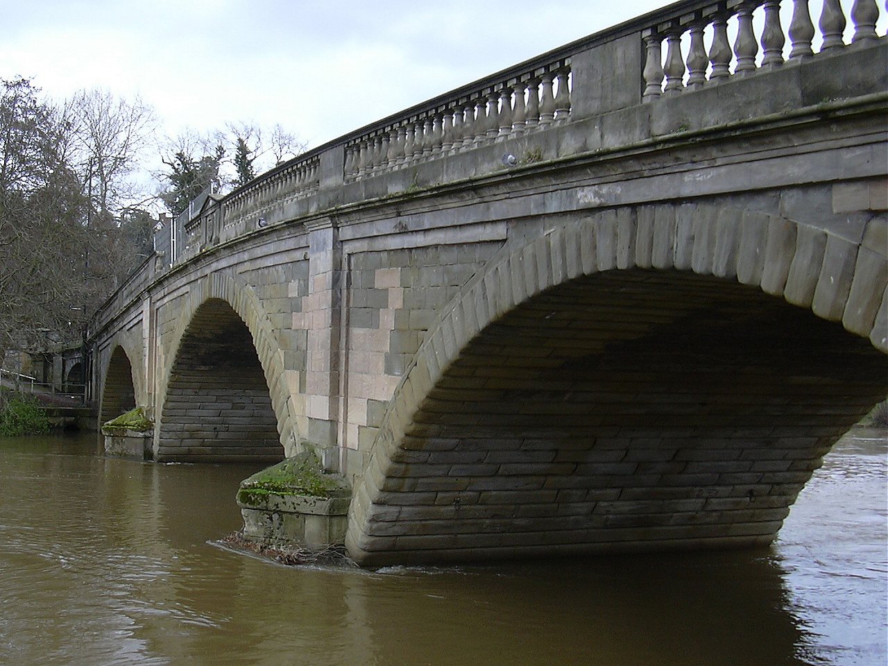
Bewdley Bridge
Bridge · 2.8 mi
Grade I listed bridge in Bewdley, Worcestershire, England

Museums and landmarks21
Bewdley Museum
Museum · 2.9 mi
Museum in Bewdley, England, United Kingdom

Hartlebury Castle
Museum · 3.4 mi
Grade I listed house in Hartlebury, Wychavon, Worcestershire, England, UK

Harvington Hall
Museum · 3.2 mi
Grade I listed historic house museum in Wyre Forest, United Kingdom


Military Wireless Museum in the Midlands
Museum
Museum in Kidderminster,Worcestershire, England, UK
Worcestershire County Museum
Museum · 3.4 mi
Museum in Hartlebury Castle, near KIdderminster, England, United Kingdom

9 more on the map.
Parks, trails and playgrounds27

West Midland Safari Park
Park · 1.8 mi
Safari park in Worcestershire, England

Kingsford Country Park
Park · 3.3 mi
Forest Park in the United Kingdom


Aggborough Stadium
Sports field and stadium · 0.6 mi
Hoo Road, Kidderminster


15 more on the map.
Restaurants and cafes112
Starbucks
Cafe · Coffee Shop · 1.3 mi
123A Stourport Road, Kidderminster
Mo-Sa 07:00-19:00; Su 08:30-17:30


The Post House
Bar and pub
92 Blackwell Street, Kidderminster
Mo-Th 11:00-23:00; Fr-Sa 11:00-25:00; Su 12:00-23:00

Wall 2 Wall
Restaurant · Indian
Exchange Street, Kidderminster
Su-Th 12:00-22:00; Fr-Sa 12:00-01:00
Larch Wood Farm
Restaurant · Steak House, Burger, Barbecue, Fish And Chips, Tex-Mex · 1.3 mi
100 more on the map.
History
The land around Kidderminster may have been first populated by the Husmerae, an Anglo-Saxon tribe first mentioned in the Ismere Diploma, a document in which Ethelbald of Mercia granted a "parcel of land of ten hides" to Cyneberht. This developed as the settlement of Stour-in-Usmere, which was later the subject of a territorial dispute settled by Offa of Mercia in 781, when he restored certain rights to Bishop Heathored. This allowed for the founding of a monastery or minstre in the area.
The earliest written form of the name Kidderminster was first documented in the Domesday Book of 1086, where it appears as Chideminstre, meaning 'Cydda or Cydela's minster or monastery'. It was a large manor held by William the Conqueror, with 16 outlying settlements (Bristitune, Fastochesfeld, Franche, Habberley, Hurcott, Mitton, Oldington, Ribbesford, Sudwale, Sutton, Teulesberge, Trimpley, Wannerton and Wribbenhall). Various spellings were in use – Kedeleministre or Kideministre (in the 12th and 13th centuries), Kyderemunstre (13th–15th centuries) – until the name of the town was settled as Kidderminster by the 16th century. Between 1156 and 1162 Henry II granted the manor to his steward, Manasser Biset. By six decades later, the settlement grew and a fair (1228) and later a market (1240) were established there.
Read more of the history
To the south by the River Stour, dating from the 15th century, is a single surviving tower of Caldwall (or Caldwell) Castle, a fortified manor house.
Kidderminster owes its growth to the early development of the cloth industry, which was aided by its position upon the River Stour, and its location at the confluence of four main roads to Birmingham, Dudley, Worcester, Bewdley and Bridgnorth. In a visit to the town sometime around 1540, King's Antiquary John Leland noted that Kidderminster "standeth most by clothing". Over the following centuries the town specialised in textile trades such as weaving, fulling, cloth working and milling, and was also home to numerous other trades including shoemaking, haberdashery, saddle making, dyers, tailors, tanners and glovers.
King Charles I granted the Borough of Kidderminster a Charter in 1636. The original charter can be viewed at Kidderminster Town Hall.
Kidderminster's location at the junction of several major roads made it strategically important during the English Civil War, with several skirmishes occurring in and around the town.
In 1670–1671, Kidderminster's cloth industry obtained a guild by act of parliament and, by 1677, the town had as many as 459 weavers and perhaps 3,000 spinners. Following King Louis XIV's revocation of the Edict of Nantes in October 1685 and the subsequent renewed persecution of French Protestants in France, many Huguenots emigrated to Britain. The immigration and settlement of waves of industrious Huguenots brought the benefits of skilled artisans, merchants and manufacturers to Britain. They contributed to a preexisting but basic cloth weaving industry in towns and cities throughout England, in some cases establishing new businesses. In Worcestershire, the Huguenots established themselves at Worcester, Evesham, Droitwich and Kidderminster.
In the early 18th century, carpet weaving was introduced to Kidderminster, and this rapidly became the staple trade of the town. Its growth was aided by the opening of the Staffordshire and Worcestershire Canal in 1771, and later the arrival of the railway to the town in 1852. The carpet industry went into decline in the 1970s, but still continues on a reduced scale.
Poor trade conditions in 1828, when 2,000 looms were not working for an 18-week period, led to riots, in which £3,000 of damage was done during one night.
The town's local government was reformed by the Municipal Reform Act 1835, which incorporated Kidderminster as a municipal borough. This superseded the charter of 1636, and divided the borough into three wards represented by six aldermen and eighteen councillors; the number of wards was doubled in the 1880s. The current Town Hall on Vicar Street was built in 1877.
Kidderminster has two Commissioners' churches. The first is St George's, on Radford Avenue; this was designed by Francis Goodwin and built in 1821–1824, finally being consecrated in April 1824. Its grant of just over £17,000.00, was the third-largest given by the commission to any church outside London. The second church is St John's, on the Bewdley Road. This was built in 1843 and the architect was Matthew Steele; its grant was just over £4,000.
The Shrubbery was converted into a military headquarters towards the end of the 19th century.
In 1974, the old borough of Kidderminster was abolished and merged into the new Wyre Forest District. In December 2015, Kidderminster was established as a civil parish with a new town council, following a public referendum.
From the History section of Kidderminster on Wikipedia, under CC BY-SA 4.0.
More about Kidderminster
Economy
The modern carpet industry was founded in the area in 1785 by Brintons. The carpet industry became extremely important to the local economy, so much so that the local newspaper is still named The Shuttle after the shuttles used on the carpet looms. A type of carpet was known as Kidderminster carpet or, in the United States, Ingrain carpet: this was a reversible carpet with no pile, with the pattern showing in opposite colours on the two faces, and was popular from the 18th to early 20th centuries. By 1951, there were more than thirty carpet manufacturers in the town, including, for example, Quayle & Tranter (now defunct). They commissioned such notable artists as George Bain to create their traditional Celtic designs.
Aided by a 2004 grant from the Heritage Lottery Fund, a museum dedicated to the Kidderminster carpet industry was officially opened by Lord Cobham in 2012.
Education
As part of educational restructuring in the Wyre Forest District, Kidderminster's schools were reorganised from a three-tier system of first, middle and high schools to the two-tier system more common in the UK as a whole, featuring primary schools and secondary schools. In this process, several first and middle schools were closed or merged into new primaries. The three high schools of King Charles I School, Wolverley C E Secondary School, and Baxter College (formerly Harry Cheshire High School) became secondary schools that included sixth forms.
Independent schools include Heathfield Knoll School in Wolverley. Formerly independent, Holy Trinity School became a state-funded free school in 2014. Kidderminster College is located in Market Street in the town centre, having moved from older premises on Hoo Road in 2003. Other local secondary schools include The Stourport High School and Sixth Form Centre and The Bewdley School.
From the Wikipedia article Kidderminster, under CC BY-SA 4.0.
Notable people from Kidderminster
 Rowland HillEnglish educational, social and postal reformer (1795-1879)Photo: The photographer is not credited in..., Public domain
 Walter NashNew Zealand politician (1882-1968)Photo: Unknown author Unknown author, Public domain
 Alex PalmerEnglish association football player (born 1996)Photo: James Cracknell, CC BY-SA 4.0
 Paul FramptonEnglish physicistPhoto: GrayhamWebb, CC BY-SA 4.0
 Ted TylerEnglish cricketer (1864-1917)Photo: No direct attribution is given for..., Public domain
 John WyerBritish racing engineer and team manager (1909-1989)Photo: paPisc from Bologna, CC BY-SA 2.0
- Peter CollinsBritish racing driver (1931-1958)
- Robert HamerBritish film director and screenwriter (1911–1963)
- Sammi DavisBritish actress
- Melissa LawleyEnglish footballer
- Alun EvansEnglish footballer (born 1949)
- Alun FrancisWelsh conductor
Born in Kidderminster, according to Wikidata (CC0). Each name links to its Wikipedia article.
Where to stay3
Churches and places of worship29
Shopping23
Gas and EV charging6
Schools, colleges and libraries22
St. Mary's Church of England (VA) Primary School
School · Anglican · 0.6 mi
Stoney Lane, Kidderminster
Healthcare15
Worcestershire Liaison and Diversion Service
Clinic and pharmacy
26 Church Street, Kidderminster
Map of Kidderminster
250 places. The map loads OpenStreetMap tiles when you open it.
Getting there and nearby towns
Birmingham Airport (BHX) is the nearest airport with scheduled flights listed in OpenStreetMap, 22 miles away.
- Stourport-on-Severn 4 mi south, about 6 min by car
- Stourbridge 7 mi northeast, about 10 min by car
- Brierley Hill 8 mi northeast, about 14 min by car
- Kingswinford 8 mi northeast, about 13 min by car
- Droitwich 9 mi southeast, about 15 min by car
- Dudley 10 mi northeast, about 17 min by car
- Wombourne 10 mi north, about 17 min by car
- Bartley Green 11 mi east, about 18 min by car
- Tipton 12 mi northeast, about 20 min by car
- Worcester 14 mi south, about 22 min by car
Drive times are estimates from straight-line distance, not routes.
Towns near Kidderminster


Keep exploring
Local news
Headlines from INDB.
Reviews, tips and questions
Loading what members have shared...
Sources and licences
- GeoNames (CC BY 4.0): population, coordinates, regions and time zone
- Mapillary (see each image): photos
- OpenStreetMap contributors (ODbL 1.0): places, airports, map data
- Wikidata (CC0 1.0): elevation, founding date, time zone, website, landmarks and historic places
- Wikimedia Commons (see each image): photos
- Wikipedia (CC BY-SA 4.0): overview and history text
Photo credits
- Bewdley Bridge from Severnside North, Loganberry, Public domain
- Exterior of Harvington Hall, Dave606 at English Wikipedia, CC BY 3.0
- Giraffes at west midlands safari park, Robek, CC BY 2.5
- Church of Saint George Kidderminster by Architect Francis Goodwin, Aspdin, CC BY-SA 3.0
- Kidderminster Hospital - DSCF0981, Rept0n1x, CC BY-SA 3.0
- Kidderminster Railway Museum - DSCF0838, Rept0n1x, CC BY-SA 3.0
- Kiddenminster - panoramio (3), Tanya Dedyukhina, CC BY 3.0
- Dowles Church, Unknown author Unknown author, CC0
- The crown. - panoramio, Steven Faulkner, CC BY 3.0
- Hartlebury Castle by ICW, IanChristopherWeston, CC BY-SA 4.0
- Street-level photo, paullancaster, CC BY-SA 4.0
- Street-level photo, trigpoint, CC BY-SA 4.0
- Street-level photo, trigpoint, CC BY-SA 4.0
- Street-level photo, endszbrxns, CC BY-SA 4.0
- Street-level photo, daniturn3, CC BY-SA 4.0
- Street-level photo, paullancaster, CC BY-SA 4.0
- Street-level photo, richardc, CC BY-SA 4.0
- Street-level photo, trigpoint, CC BY-SA 4.0
- Street-level photo, uk360, CC BY-SA 4.0
- Street-level photo, paullancaster, CC BY-SA 4.0
- Street-level photo, endszbrxns, CC BY-SA 4.0
- Street-level photo, daniturn3, CC BY-SA 4.0
- Street-level photo, daniturn3, CC BY-SA 4.0
- Street-level photo, southglos, CC BY-SA 4.0
- Street-level photo, trigpoint, CC BY-SA 4.0


Page built November 10, 2026. Spotted a mistake? Tell us or suggest a place.