


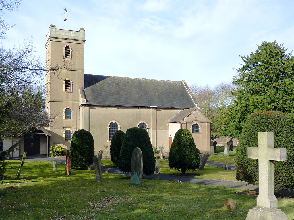

Wombourne, United Kingdom
Wombourne is a town of 13,511 people in England, United Kingdom.
Why visit Wombourne
Townapedia lists 5 museums and landmarks, 10 parks and trails, 27 places to eat, 1 place to stay and 2 attractions in and around town.
Highlights include Himley Hall, Holbeche House, Baggeridge Country Park and Himley Park.
Weather in Wombourne
Forecast from MET Norway (CC BY 4.0). Full forecast
About Wombourne
Wombourne is a large village and civil parish located in the district of South Staffordshire, in the county of Staffordshire, England. It is 4 miles (6 km) south-west of Wolverhampton and on the border with the West Midlands county.
From the Wikipedia article Wombourne (this version), under CC BY-SA 4.0.
Photos of Wombourne


Things to do2

Museums and landmarks5



Broadfield House Glass Museum
Museum · 2.9 mi
Art, craft and social history museum in Kingswinford, West Midlands

Parks, trails and playgrounds10

Baggeridge Country Park
Park · 1.3 mi
Country park in Staffordshire, England
Barrow Hill Local Nature Reserve
Park · 3.1 mi
Park in Pensnett, Dudley, West Midlands, England

Himley Hall Golf Centre/Club
Golf course · 1.2 mi
9 hole Par 35 & 9 hole Pitch & Putt
Himley Road, Dudley

South Staffordshire Railway Walk Local Nature Reserve
Hiking and trails · 0.8 mi

Restaurants and cafes27




15 more on the map.
History
The village has Anglo-Saxon origins, and was part of the large central kingdom of Mercia, which was settled by Angles. The whole region was wooded when the Germanic settlers arrived, and hamlet names like Bratch ("newly-cleared-land") and Blakeley ("dark clearing") attest to the need to clear land for settlement. The settlers reared large herds of pigs, which were easily fed in the beech, oak and birch woods, which are the naturally-predominant vegetation in the region. Local toponyms like Kingswinford ("royal pig crossing") and Swindon ("pig hill") confirm the importance of pig rearing in Anglo-Saxon times.
Read more of the history
Wombourne is mentioned in the Domesday Book of 1086, and was clearly a medium-sized village by the standards of the time. Before the Norman Conquest, it was owned by an Anglo-Saxon nobleman called Thorsten. By the time of the Domesday survey, William Fitz Ansculf held seven hides of land, some of them let from him by one Ralph of Wombourne. William was an important landowner throughout the West Midlands, the son of Ansculf of Picquigny, a Picard baron who came to England with William the Conqueror and built a castle at Dudley. William's total holding at Wombourne supported 8 ploughs and was worth £3. There were 13 villagers (probably not including dependents, so perhaps thirty to forty people in total); a priest, and so perhaps some sort of church; as well as two mills, the first evidence for the importance of water power in the area. Wombourne was part of the Seisdon Hundred.
The Priors of Dudley built or rebuilt the Parish Church of St Benedict Biscop around 1170, the only parish church dedicated to this Anglo-Saxon cleric. The building as it is seen today, however, is the result of numerous reconstructions and refurbishments, with a near-complete rebuilding undertaken 1866–1867 to the designs of George Edmund Street. However, the 14th-century west tower survives. The parish of Wombourne extended far from the village, taking in Orton and Swindon.
For most of its history Wombourne was mainly an agricultural village. However, its involvement with industry began unusually early. From the Middle Ages, the Smestow Brook and the Stour were lined with small iron bloomeries and forges, using local reserves of charcoal and water. The Industrial Revolution brought coke-fired furnaces. In 1772, the Staffordshire and Worcestershire Canal was opened, with major canal locks at the Bratch and Bumble Hole, integrating the area more closely into industrial Britain. Iron production concentrated in a smaller number of centres – at Swindon, in the southern part of the Wombourn parish, at Gothersley, at the Hyde near Kinver, and increasingly in the nearby Black Country – using the canal to bring ore, coal and limestone to the works. Other villages, however, remained centres for smithing, with cheaper and more available iron greatly increasing the number of workers. Increasingly, Wombourne became a centre for nail-making. The Wom and the Smestow continued to provide both power and cooling water, with several large mills along each stream by the late 18th century.
Perhaps the largest water-driven forge was to the west of the village, where, an 1817 history remarks, "has been erected an iron-work called the Heath-forge, with genteel mansion". This works had a large mill pool, supplied by the Merryhill Brook and by a contour canal from the River Smestow. Water fell thence in several stages to the Wom, which then joined the Smestow a short distance to the west. The forge mill was later converted into a corn mill, which functioned until the 1930s. The Heath Mill industrial estate on the main Bridgnorth road preserves the name of the complex. The mansion building, now converted into flats, is still to be seen in the Poolhouse estate, itself named after the poolhouse that stood at the dam. The water mill is clearly marked on the 1775 Yates map of Staffordshire, along with one at the Wodehouse, and another just south of the village centre, the remains of which are now the Pool Dam.
It was around the same time that the Hellier family reached the peak of their influence in the area. The Helliers lived at the Wodehouse, on the Wom Brook, to the east of the village. It was the fourth Samuel Hellier, knighted in 1762, who turned the Jacobean house into a centre of culture. He had the grounds laid out in fashionable style, with a hermitage, a temple to the memory of Handel, and a music room. He spent a fortune on musical instruments and books of music, building up a private collection and endowing both the church at Wombourne and St. John's, Wolverhampton. The family collection included the Stradivarius named after them. Dying without issue in 1784, he left his property to a family friend, the Reverend Thomas Shaw, on condition he change his name to Hellier. One of his descendants spent years as commandant of the Royal Military School of Music at Kneller Hall. It is claimed that the Wodehouse has not been sold for over 900 years.
In 1851, Wombourne was described by William White as a large village, "occupied chiefly by nailors, who work for the neighbouring manufacturers". Nail-making remained important into the 20th century. As White implies, it was mainly the preserve of outworkers, who operated small-scale machinery in, or attached to, their own homes, fetching iron sheet or rod from the foundries and returning the finished product.
White tells us that the main landowners in the area in the mid-19th century were John Wrottesley, 2nd Baron Wrottesley, a notable astronomer, and Lord Ward – at this time the Reverend William Humble Ward, the tenth Baron, a relative of the Earl of Dudley. The Wards made their wealth not merely from land, but what lay under it: the coal and limestone of the West Midlands. Another important landowner, the Reverend William Dalton, was an Evangelical clergyman from Ulster, but he owed his wealth to marriage to the widow of a Bilston iron master.
From the History section of Wombourne on Wikipedia, under CC BY-SA 4.0.
Notable people from Wombourne
 Pip HarrisBritish motorcycle racer (1927-2013)Photo: This photo was taken by Przemysław..., Public domain
- Johnny BrittainBritish motorcycle racer (1931-2019)
- Ian PainterEnglish footballer and manager (born 1964)
- William ReadingEnglish priest and librarian
Born in Wombourne, according to Wikidata (CC0). Each name links to its Wikipedia article.
Where to stay1
Churches and places of worship9
Shopping5
Gas and EV charging1
Schools, colleges and libraries8
St Bernadette's Catholic Primary School
School · Roman Catholic · 0.7 mi
Lindale Drive, Wolverhampton
St John's CE (C) Primary School
School · Anglican · 1.5 mi
Wombourne Road, Dudley
Healthcare2
Map of Wombourne
70 places. The map loads OpenStreetMap tiles when you open it.
Getting there and nearby towns
Birmingham Airport (BHX) is the nearest airport with scheduled flights listed in OpenStreetMap, 19 miles away.
- Wolverhampton 4 mi northeast, about 7 min by car
- Dudley 5 mi southeast, about 8 min by car
- West Bromwich 8 mi east, about 13 min by car
- Walsall 9 mi northeast, about 15 min by car
- Birmingham 12 mi east, about 20 min by car
- Telford 15 mi northwest, about 24 min by car
- Sutton Coldfield 16 mi east, about 25 min by car
- Solihull 19 mi southeast, about 30 min by car
- Worcester 24 mi south, about 38 min by car
- Coventry 30 mi east, about 48 min by car
Drive times are estimates from straight-line distance, not routes.
Towns near Wombourne


Keep exploring
Local news
Headlines from INDB.
Reviews, tips and questions
Loading what members have shared...
Sources and licences
- GeoNames (CC BY 4.0): population, coordinates, regions and time zone
- Mapillary (see each image): photos
- OpenStreetMap contributors (ODbL 1.0): places, airports, map data
- Wikidata (CC0 1.0): elevation, founding date, time zone, website, landmarks and historic places
- Wikimedia Commons (see each image): photos
- Wikipedia (CC BY-SA 4.0): overview and history text
Photo credits
- 6 Gavel Hill, Wombourne, Roger Kidd, CC BY-SA 2.0
- St James the Great's Church, Church Street, Lower Gornal (NHLE Code 1270306) (August 2025) (4), User:Hassocks5489, CC0
- St Bartholomew's Church, Penn, Row17, CC BY-SA 2.0
- Holbeche House 357708 37f6fbc8, Gordon Griffiths, CC BY-SA 2.0
- St Michael's Church, Himley, Roger Kidd, CC BY-SA 2.0
- The Dudley Arms, Himley, Bill Boaden, CC BY-SA 2.0
- Crooked House (8061973923), Peter Broster, CC BY 2.0
- Wombrook Lower End Bridge, Sjwells53, CC BY-SA 3.0
- Wom Brook at Pool Dam, Sjwells53, CC BY-SA 3.0
- Watch the King’s Coronation live at Himley Hall (52863756117), Dudley Council from England, CC BY 2.0
- Street-level photo, southglos, CC BY-SA 4.0
Page built November 10, 2026. Spotted a mistake? Tell us or suggest a place.