


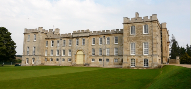

Kimbolton, United Kingdom
Kimbolton is a town of 1,103 people in England, United Kingdom.
Why visit Kimbolton
Townapedia lists 3 museums and landmarks, 4 parks and trails, 5 places to eat and 1 attraction in and around town.
Highlights include Kimbolton Castle, Shepherd's Close and Grafham Water.
Weather in Kimbolton
Forecast from MET Norway (CC BY 4.0). Full forecast
About Kimbolton
Kimbolton (; kim-BOWL-tən) is a town and civil parish in the Huntingdonshire district of Cambridgeshire, England. Kimbolton is about 9 miles (14 km) west of Huntingdon and 14 miles (23 km) north of Bedford.
From the Wikipedia article Kimbolton, Cambridgeshire (this version), under CC BY-SA 4.0.
Travel tips from other travellers: Kimbolton on Wikivoyage (CC BY-SA 4.0).
Things to do1

Museums and landmarks3


Parks, trails and playgrounds4


Restaurants and cafes5




History
Archaeological discoveries near to the airfield indicate the possible presence of a Roman settlement. The name Kimbolton, however, is Anglo-Saxon, translating as “Cenebald’s ton” (an enclosure or homestead).
Kimbolton, and the lands of its soke, comprised the only estate of King Harold in Huntingdonshire. It is believed that Harold had a hunting lodge nearby. The town was listed as Chenebaltone and Kenebaltone in the Domesday Book of 1086 in the Hundred of Leightonstone in Huntingdonshire. The survey records that there were 20 ploughlands at Kimbolton in 1086 and, in addition to the arable land, there were 70 acres (28 hectares) of meadows, 3,784 acres (1,531 hectares) of woodland and a water mill. There was already a church and a priest at Kimbolton.
The parish church of St Andrew is Grade I listed. Many members of the Montagu family (Earls and Dukes of Manchester of Kimbolton) are buried at St Andrew's. Several Montagu monuments still exist in the South Chapel, while the Montagu vault (extended in 1853) is located beneath the North Chapel.
The main road through Kimbolton bends through four tight right angles in quick succession. Originally, the road travelled directly through the outskirts of the town, nearer to the River Kym to the north.
The parish also includes the hamlet of Stonely, site of the former Augustinian Stoneley Priory.
Read more of the history
In the centre of the town is Kimbolton Castle which now forms the main building of Kimbolton School (an independent day and boarding secondary school), but its predecessor on the same site was once home and prison to Catherine of Aragon after her divorce from Henry VIII. Catherine died at Kimbolton Castle in 1536 and was transported from there to Peterborough Cathedral to be buried.
From the History section of Kimbolton, Cambridgeshire on Wikipedia, under CC BY-SA 4.0.
Churches and places of worship6
Shopping2
Schools, colleges and libraries3
Healthcare1
Map of Kimbolton
25 places. The map loads OpenStreetMap tiles when you open it.
Getting there and nearby towns
Sywell Aerodrome (ORM) is the nearest airport with scheduled flights listed in OpenStreetMap, 17 miles away.
- Riseley 5 mi southwest, about 8 min by car
- Saint Neots 8 mi southeast, about 12 min by car
- Sharnbrook 8 mi southwest, about 13 min by car
- Ringstead 8 mi northwest, about 14 min by car
- Rushden 9 mi west, about 14 min by car
- Huntingdon 9 mi east, about 14 min by car
- Bedford 12 mi south, about 19 min by car
- Sandy 12 mi south, about 20 min by car
- Wellingborough 13 mi west, about 21 min by car
- Kempston 13 mi south, about 22 min by car
Drive times are estimates from straight-line distance, not routes.
Towns near Kimbolton


Keep exploring
Local news
Headlines from INDB.
Reviews, tips and questions
Loading what members have shared...
Sources and licences
- GeoNames (CC BY 4.0): population, coordinates, regions and time zone
- OpenStreetMap contributors (ODbL 1.0): places, airports, map data
- Wikidata (CC0 1.0): elevation, founding date, time zone, website, landmarks and historic places
- Wikimedia Commons (see each image): photos
- Wikipedia (CC BY-SA 4.0): overview and history text
Photo credits
- Kimbolton Castle 02, Graham Taylor, CC BY-SA 2.0
- Shepherd's Close 8, Dudley Miles, CC BY-SA 4.0
- Little Staughton All Saints Church, Flutophilus, CC BY-SA 3.0
- Pertenhall Church of St Peter, Flutophilus, CC BY-SA 3.0
- Kimbolton Castle 01, Graham Taylor, CC BY-SA 2.0
- Racing Citroën 2CV, Freggs, CC BY-SA 2.0
Page built November 10, 2026. Spotted a mistake? Tell us or suggest a place.