
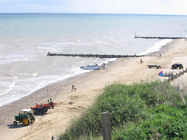


Mundesley, United Kingdom
Mundesley is a town of 2,755 people in England, United Kingdom.
Why visit Mundesley
Townapedia lists 2 museums and landmarks, 3 parks and trails, 11 places to eat and 6 places to stay in and around town.
Highlights include Bromholm Priory, Knapton Cutting and Pigneys Wood.
Weather in Mundesley
Forecast from MET Norway (CC BY 4.0). Full forecast
About Mundesley
Mundesley /ˈmʌn.zli/ is a coastal village and a civil parish in the English county of Norfolk. The village is 20 miles (32 km) north-northeast of Norwich, 7 miles (11 km) southeast of Cromer and 6 miles (9.7 km) north-northeast of the town of North Walsham.
From the Wikipedia article Mundesley (this version), under CC BY-SA 4.0.
Photos of Mundesley


Museums and landmarks2

Bromholm Priory
Monument and historic site · 3.2 mi
Monastery in Bacton, Norfolk, England, UK

Parks, trails and playgrounds3


Restaurants and cafes11


The Catch
Fast food · Fish And Chips · 0.4 mi
21 Beach Road, Norwich





Where to stay6



History
Mundesley has an entry in the Domesday Book of 1086, with the town's name recorded as Muleslai. The main landholder was William de Warenne, and the survey also lists a church.
The Mundesley Memorial Bomb is dedicated to Army teams who removed mines after the Second World War. There is a War memorial inside the Church and on the seafront at the Coastwatch station and museum. Near to the church is a World War II gun emplacement, which now stands near the edge of the cliff, due to coastal erosion.
From the History section of Mundesley on Wikipedia, under CC BY-SA 4.0.
More about Mundesley
Arts and culture
Mundesley is a popular seaside holiday destination due to its sandy beaches and has a number of holiday chalet and caravan parks and hotels. Just to the south of Mundesley on the road to Paston is a popular windmill, Stow Mill. The village was a popular seaside resort in Victorian times, benefiting from its own railway station which closed in 1964.
The village has an historic golf course in the Mun Valley, established in 1901 and designed with the help of six-times Open Champion Harry Vardon. Vardon convalesced at the nearby sanitorium while recovering from tuberculosis and his association with the course spanned many years. It is said that he scored his only hole-in-one on what is now the sixth. The course was altered when land was required for wartime farming and was redesigned when the conflicts ended.
From the Wikipedia article Mundesley, under CC BY-SA 4.0.
Churches and places of worship5
Shopping4
Schools, colleges and libraries3
Healthcare1
Map of Mundesley
35 places. The map loads OpenStreetMap tiles when you open it.
Getting there and nearby towns
Norwich Airport (NWI) is the nearest airport with scheduled flights listed in OpenStreetMap, 16 miles away.
- North Walsham 4 mi southwest, about 7 min by car
- Overstrand 5 mi northwest, about 7 min by car
- Buxton 10 mi southwest, about 16 min by car
- Coltishall 11 mi south, about 17 min by car
- Horning 12 mi south, about 19 min by car
- Cawston 13 mi southwest, about 22 min by car
- Spixworth 14 mi south, about 23 min by car
- Rackheath 15 mi south, about 24 min by car
- Reepham 16 mi southwest, about 25 min by car
- Norwich 18 mi south, about 29 min by car
Drive times are estimates from straight-line distance, not routes.
Towns near Mundesley


Keep exploring
Local news
Headlines from INDB.
Reviews, tips and questions
Loading what members have shared...
Sources and licences
- GeoNames (CC BY 4.0): population, coordinates, regions and time zone
- OpenStreetMap contributors (ODbL 1.0): places, airports, map data
- Wikidata (CC0 1.0): elevation, founding date, time zone, website, landmarks and historic places
- Wikimedia Commons (see each image): photos
- Wikipedia (CC BY-SA 4.0): overview and history text
Photo credits
- MundesleyBeachInSummer(StephenCraven)Aug2006, Stephen Craven, CC BY-SA 2.0
- -1905 Mundesley-on-Sea railway station, Norfolk (2), Herbert Watkins, Public domain
- -1905 Mundesley Railway Station, Norfolk, Herbert Watkins, Public domain
- -2019-06-07 Back lane next to Links chalet park, Mundesley (1), Kolforn ( Kolforn ) I'd appreciate if you could mail me ([email protected]) if you want to use this picture out of the Wikimedia project scope. This file is licensed under the Creative Commons..., CC BY-SA 4.0
- -2019-06-07 Links chalet park, Mundesley (3), Kolforn ( Kolforn ) I'd appreciate if you could mail me ([email protected]) if you want to use this picture out of the Wikimedia project scope. This file is licensed under the Creative Commons..., CC BY-SA 4.0
- -2018-10-20 Alpacas (Vicugna pacos), Mundesley (2), Kolforn ( Kolforn ) I'd appreciate if you could mail me ([email protected]) if you want to use this picture out of the Wikimedia project scope. This file is licensed under the Creative Commons..., CC BY-SA 4.0
- -2018-10-20 Alpacas (Vicugna pacos), Mundesley (1), Kolforn ( Kolforn ) I'd appreciate if you could mail me ([email protected]) if you want to use this picture out of the Wikimedia project scope. This file is licensed under the Creative Commons..., CC BY-SA 4.0
- -2018-10-20 Alpacas (Vicugna pacos), Mundesley (3), Kolforn ( Kolforn ) I'd appreciate if you could mail me ([email protected]) if you want to use this picture out of the Wikimedia project scope. This file is licensed under the Creative Commons..., CC BY-SA 4.0
- -2019-11-06 Mundesley telephone exchange, Church Lane, Mundesley, Kolforn ( Kolforn ) I'd appreciate if you could mail me ([email protected]) if you want to use this picture out of the Wikimedia project scope. This file is licensed under the Creative Commons..., CC BY-SA 4.0
- -2019-06-07 Back lane next to Links chalet park, Mundesley (3), Kolforn ( Kolforn ) I'd appreciate if you could mail me ([email protected]) if you want to use this picture out of the Wikimedia project scope. This file is licensed under the Creative Commons..., CC BY-SA 4.0
- -2019-06-07 Back lane next to Links chalet park, Mundesley (2), Kolforn ( Kolforn ) I'd appreciate if you could mail me ([email protected]) if you want to use this picture out of the Wikimedia project scope. This file is licensed under the Creative Commons..., CC BY-SA 4.0
- -2019-06-07 Links chalet park, Mundesley (2), Kolforn ( Kolforn ) I'd appreciate if you could mail me ([email protected]) if you want to use this picture out of the Wikimedia project scope. This file is licensed under the Creative Commons..., CC BY-SA 4.0
- -2019-06-07 Links chalet park, Mundesley (1), Kolforn ( Kolforn ) I'd appreciate if you could mail me ([email protected]) if you want to use this picture out of the Wikimedia project scope. This file is licensed under the Creative Commons..., CC BY-SA 4.0
- -2020-01-15 Warren Drive, Mundesley, Kolforn ( Kolforn ) I'd appreciate if you could mail me ([email protected]) if you want to use this picture out of the Wikimedia project scope. This file is licensed under the Creative Commons..., CC BY-SA 4.0
- -1905 Mundesley-on-Sea railway station, Norfolk (1), Herbert Watkins, Public domain
- -2020-02-04 Warren Drive, Mundesley, Kolforn ( Kolforn ) I'd appreciate if you could mail me ([email protected]) if you want to use this picture out of the Wikimedia project scope. This file is licensed under the Creative Commons..., CC BY-SA 4.0
- -2018-12-04 Station road, Mundesley, Kolforn ( Kolforn ) I'd appreciate if you could mail me ([email protected]) if you want to use this picture out of the Wikimedia project scope. This file is licensed under the Creative Commons..., CC BY-SA 4.0
- -2020-01-15 Links chalet park, Links Road, Mundesley, Kolforn ( Kolforn ) I'd appreciate if you could mail me ([email protected]) if you want to use this picture out of the Wikimedia project scope. This file is licensed under the Creative Commons..., CC BY-SA 4.0
- -2019-10-28 Looking north along Hilda Road, Mundesley, Kolforn ( Kolforn ) I'd appreciate if you could mail me ([email protected]) if you want to use this picture out of the Wikimedia project scope. This file is licensed under the Creative Commons..., CC BY-SA 4.0
- -2020-12-30 Discarded COVID-19 facemask, Cromer Road, Mundesley, Kolforn ( Kolforn ) I'd appreciate if you could mail me ([email protected]) if you want to use this picture out of the Wikimedia project scope. This file is licensed under the Creative Commons..., CC BY-SA 4.0
- Knapton Cutting (4), Dudley Miles, CC BY-SA 4.0
- 2018-05-07 Parish church of Saint-John the-Baptist's head, Trimingham, Kolforn ( Kolforn ) I'd appreciate if you could mail me ([email protected]) if you want to use this picture out of the Wikimedia project scope. This file is licensed under the Creative Commons..., CC BY-SA 4.0
- Gimingham Church, Norfolk, Adrian S Pye, CC BY-SA 2.0
- -2020-12-30 South elevation, All Saints, Mundesley, Kolforn ( Kolforn ) I'd appreciate if you could mail me ([email protected]) if you want to use this picture out of the Wikimedia project scope. This file is licensed under the Creative Commons..., CC BY-SA 4.0
- -2019-12-29 Mundesley Libiray, Cromer Road, Mundesley (1), Kolforn ( Kolforn ) I'd appreciate if you could mail me ([email protected]) if you want to use this picture out of the Wikimedia project scope. This file is licensed under the Creative Commons..., CC BY-SA 4.0
- -2021-01-01 Sexton Lodge, Felbrigg, Norfolk, Kolforn ( Kolforn ) I'd appreciate if you could mail me ([email protected]) if you want to use this picture out of the Wikimedia project scope. This file is licensed under the Creative Commons..., CC BY-SA 4.0
- -2019-12-30 North Transept, Bromholm Priory, Bacton (2), Kolforn ( Kolforn ) I'd appreciate if you could mail me ([email protected]) if you want to use this picture out of the Wikimedia project scope. This file is licensed under the Creative Commons..., CC BY-SA 4.0
- -2022-05-22 Footpath, Pigneys Wood, Norfolk, England, David Pashley, CC BY-SA 2.0
- 2018-07-18 Mundesley golf course (4), Kolforn ( Kolforn ) I'd appreciate if you could mail me ([email protected]) if you want to use this picture out of the Wikimedia project scope. This file is licensed under the Creative Commons..., CC BY-SA 4.0
- -2018-09-30 Anchor outside 'The Ship Inn', Beach Road, Mundesley, Kolforn ( Kolforn ) I'd appreciate if you could mail me ([email protected]) if you want to use this picture out of the Wikimedia project scope. This file is licensed under the Creative Commons..., CC BY-SA 4.0
- 2018-06-20 New Sage chinese restaurant and take-away, Cromer Road, Mundesley, Kolforn ( Kolforn ) I'd appreciate if you could mail me ([email protected]) if you want to use this picture out of the Wikimedia project scope. This file is licensed under the Creative Commons..., CC BY-SA 4.0
- -2021-09-01 The Catch fish and chip shop, Mundesley, Norfolk (1), Kolforn ( Kolforn ) I'd appreciate if you could mail me ([email protected]) if you want to use this picture out of the Wikimedia project scope. This file is licensed under the Creative Commons..., CC BY-SA 4.0
- 2018-06-20 The Village Chippy, Beach Road, Mundesley, Kolforn ( Kolforn ) I'd appreciate if you could mail me ([email protected]) if you want to use this picture out of the Wikimedia project scope. This file is licensed under the Creative Commons..., CC BY-SA 4.0
- -2019-01-09 The old Brick Kiln, Kiln Cliffs caravan park, Mundesley, Kolforn ( Kolforn ) I'd appreciate if you could mail me ([email protected]) if you want to use this picture out of the Wikimedia project scope. This file is licensed under the Creative Commons..., CC BY-SA 4.0


Page built November 10, 2026. Spotted a mistake? Tell us or suggest a place.